Wald am Schoberpass
Wald am Schoberpass is a municipality in the district of Leoben in the Austrian state of Styria.
Wald am Schoberpaß | |
|---|---|
 Coat of arms | |
 Wald am Schoberpaß Location within Austria | |
| Coordinates: 47°26′N 14°40′E | |
| Country | Austria |
| State | Styria |
| District | Leoben |
| Government | |
| • Mayor | Hans Schrabacher (SPÖ) |
| Area | |
| • Total | 90.43 km2 (34.92 sq mi) |
| Elevation | 841 m (2,759 ft) |
| Population (2018-01-01)[2] | |
| • Total | 586 |
| • Density | 6.5/km2 (17/sq mi) |
| Time zone | UTC+1 (CET) |
| • Summer (DST) | UTC+2 (CEST) |
| Postal code | 8781 |
| Area code | 03834 |
| Vehicle registration | LN |
| Website | www.schoberpass.at |
Geography
The Schober Pass (elevation 849 metres or 2,785 feet) is a high mountain pass within the municipality. Wald am Schoberpaß lies on the Schober Pass between the Niederen Tauern and the Eisenerz Alps. The pass separates the watershed of the Palten, which flows into the Enns, and the Liesing, which flows into the Mur.
References
- "Dauersiedlungsraum der Gemeinden Politischen Bezirke und Bundesländer - Gebietsstand 1.1.2018". Statistics Austria. Retrieved 10 March 2019.
- "Einwohnerzahl 1.1.2018 nach Gemeinden mit Status, Gebietsstand 1.1.2018". Statistics Austria. Retrieved 9 March 2019.
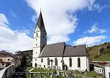
Parish church St. Cunigunde
| Authority control |
|
|---|
This article is issued from Wikipedia. The text is licensed under Creative Commons - Attribution - Sharealike. Additional terms may apply for the media files.