El Castillo, Texas
El Castillo (in Spanish: Castle) is a Census-designated place located in Starr County, Texas. It is a new CDP formed from part of the old La Victoria CDP for the 2010 census with a population of 188.[2]
El Castillo, Texas | |
|---|---|
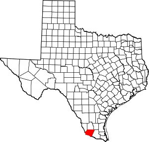
 Location of El Castillo, Texas | |
| Coordinates: 26°20′6″N 98°38′19″W | |
| Country | United States |
| State | Texas |
| Area | |
| • Total | 0.03 sq mi (0.07 km2) |
| • Land | 0.03 sq mi (0.07 km2) |
| • Water | 0.0 sq mi (0.0 km2) |
| Elevation | 0.23 ft (0.07 m) |
| Population (2010) | |
| • Total | 188 |
| • Density | 7,000/sq mi (2,700/km2) |
| Time zone | UTC-6 (Central (CST): UTC-6) |
| • Summer (DST) | UTC-5 (CDT) |
| ZIP code | 78582 |
| GNIS feature ID | 2584627[1] |
Geography
El Castillo is located at 26°20′6″N 98°38′19″W (26.334926, -98.638659).[3] According to the United States Census Bureau, El Castillo has a total area of 0.07 km2, of which 0.07 km2 is land and (0%) 0r km2 is water.[4]
Demographics
According to the 2010 US Census, there were 188 people residing in El Castillo.[5] The density was 2.592,4 inhabitants / km2. Populated for 188 inhabitants, El Castillo was composed of the 76.06% white, the 22.87% of other races and the 1.06% belonged to two or more races. Of the total population, 100% were Hispanic and Latino of any race.[6]
References
- U.S. Geological Survey Geographic Names Information System: El Castillo, Texas
- "Population and Housing Unit Counts, 2010 Census of Population and Housing" (PDF). Texas: 2010.
- "El Castillo, Texas :: Boundary Map of El Castillo, Texas". Archived from the original on 2016-12-22. Retrieved 2016-12-21.
- Find A County Archived 2012-07-12 at WebCite. National Association of county. Retrieved in May 2, 2013
- American FactFinder. United States Census Bureau. Retrieved in May 2, 2013.
- US Board on Geographic Names. United States Geological Service. Posted in October 25, 2007. Retrieved in May 2, 2013.