El Pinar, Uruguay
El Pinar is a seaside resort of the Canelones Department, Uruguay. In 1994, when Ciudad de la Costa took on the status of a city, El Pinar was incorporated in it.
El Pinar | |
|---|---|
Resort of Ciudad de la Costa | |
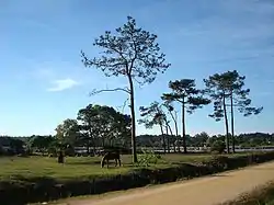 East end of El Pinar at Arroyo Pando. | |
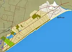 Location of El Pinar in Ciudad de la Costa | |
| Coordinates: 34°47′50″S 55°54′35″W | |
| Country | |
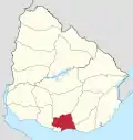
| Department | Canelones Department |
| Population (2011) | |
| • Total | 21,091 |
| Time zone | UTC -3 |
| Postal code | 15008 |
| Dial plan | +598 2 (+7 digits) |
Location
El Pinar is the easternmost locality of Ciudad de la Costa, after which starts the group of resorts known as Costa de Oro. Its south limit is the coastline of the Río de la Plata and it shares borders with Lomas de Solymar to the west, with Neptunia to the east, with the stream Arroyo Pando separating the two, and with Country Villa Juana to the north.
Places of worship
- St. Rose of Lima Parish Church (Roman Catholic, Dehonians)
Population
In 2011 El Pinar had a population of 21,091.[1][2]
| Year | Population |
|---|---|
| 1963 | 394 |
| 1975 | 1,874 |
| 1985 | 3,479 |
| 1996 | 10,383 |
| 2004 | 17,221 |
| 2011 | 21,091 |
Source: Instituto Nacional de Estadística de Uruguay[3]
Street map
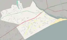
Street map of El Pinar
References
- "Censos 2011 Cuadros Canelones". INE. 2012. Archived from the original (XLS) on 10 October 2012. Retrieved 25 August 2012.
- "Censos 2011 Canelones (flash plugin needed)". INE. 2012. Archived from the original on 7 September 2012. Retrieved 25 August 2012.
- "1963–1996 Statistics / E" (DOC). Instituto Nacional de Estadística de Uruguay. 2004. Retrieved 29 June 2011.
External links
| Wikimedia Commons has media related to El Pinar, Canelones. |
Capital: Canelones | ||
| Towns and villages |
|  |
| Resorts of the Ciudad de la Costa | ||
| Sights |
| |
This article is issued from Wikipedia. The text is licensed under Creative Commons - Attribution - Sharealike. Additional terms may apply for the media files.
