Elizabeth Street, Brisbane
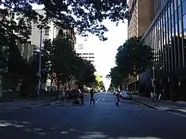
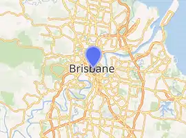
Elizabeth Street in Brisbane, Australia is a major street in the centre of the city. The street was established at the beginning of settlement in Brisbane as a penal colony.[1] Most of the street is fronted by low-level retail outlets, with an increase in mixed use skyscrapers being recently constructed.
Elizabeth Street | |
|---|---|
 | |
Elizabeth Street from Creek Street intersection. | |

| |
 Elizabeth Street | |
| Coordinates | |
| General information | |
| Type | Street |
| Location | Brisbane |
Geography
Major shopping arcades on Elizabeth Street include The Myer Centre, Marcarthur Central and the Elizabeth Arcade. The Brisbane Hilton hotel has it main entrance on Elizabeth Street. The offices at Central Plaza Two have their entrance at the easterly end or downtown part of the street.
There is good pedestrian access around the street, such as pathways near the General Post Office and access to the Queen Street bus station via the Myer Centre. The street runs parallel to and south of the city's central mall in Queen Street. To ease congestion in the Brisbane central business district traffic direction is one-way from west to east.
At the top of the street nearest the Brisbane River is William Street and exit ramps from the Riverside Expressway. Between this intersection and George Street is the Queens Gardens, a small open park. Adjacent to this is the Treasury Building and the Conrad Treasury Casino, which is open 24 hours a day.
Elizabeth Street was one of various Brisbane locations used in the filming of the 2015 motion picture San Andreas. The street was used to represent downtown San Francisco after a major earthquake struck the city, with over 300 extras participating in the shooting of the scene.
History
Brisbane's first theatre, the Theatre Royal was at 80 Elizabeth Street. It was first built in 1865, was remodelled on a number of occasions and was demolished in 1987 to make way for the Myer Centre.[2]
Heritage listings
Elizabeth Street has a number of heritage-listed sites, including:
- 171 Elizabeth Street: Heckelmanns Building[3]
- 179 Elizabeth Street: Tara House (Irish Club)[4]
- 249 Elizabeth Street: Old St Stephens Church[5]
- 259-269 Elizabeth Street: St Stephens Catholic Cathedral[6]
- 283 Elizabeth Street: Telecommunications House[7]
- Sections of Albert St, George St, William St, North Quay, Queen's Wharf Rd: Early Streets of Brisbane (includes land now on Elizabeth Street) [8]
- 144 George Street: Queens Gardens (on the corner of Elizabeth Street)[9]
- 167 Albert Street: Perry House (on the corner of Elizabeth Street)[10]
- 171 George Street: Family Services Building (on the corner of Elizabeth Street)[11]
- 179 - 191 George Street: Hunters Buildings (Treasury Chambers, St Francis House & Symons Building), a L-shaped building which fronts both George and Elizabeth Streets[12]
Major intersections
References
- "Early Streets of Brisbane (entry 645611)". Queensland Heritage Register. Queensland Heritage Council.
- "Theatre Royal". resource.acu.edu.au. Archived from the original on 27 February 2020. Retrieved 1 November 2019.
- "Heckelmanns Building (entry 600104)". Queensland Heritage Register. Queensland Heritage Council. Retrieved 19 June 2013.
- "Tara House (Irish Club) (entry 600105)". Queensland Heritage Register. Queensland Heritage Council. Retrieved 19 June 2013.
- "Old St Stephens Church (entry 600108)". Queensland Heritage Register. Queensland Heritage Council. Retrieved 19 June 2013.
- "St Stephens Cathedral (entry 600107)". Queensland Heritage Register. Queensland Heritage Council. Retrieved 19 June 2013.
- "Telecommunications House (former) (entry 600110)". Queensland Heritage Register. Queensland Heritage Council. Retrieved 19 June 2013.
- "Early Streets of Brisbane (entry 700011)". Queensland Heritage Register. Queensland Heritage Council. Retrieved 19 June 2013.
- "Queens Gardens (entry 600112)". Queensland Heritage Register. Queensland Heritage Council. Retrieved 19 June 2013.
- "Perry House (entry 600103)". Queensland Heritage Register. Queensland Heritage Council. Retrieved 19 June 2013.
- "Family Services Building (entry 600111)". Queensland Heritage Register. Queensland Heritage Council. Retrieved 19 June 2013.
- "Treasury Chambers & St Francis House & Symons Building (entry 600116)". Queensland Heritage Register. Queensland Heritage Council. Retrieved 19 June 2013.
External links
![]() Media related to Elizabeth Street, Brisbane at Wikimedia Commons
Media related to Elizabeth Street, Brisbane at Wikimedia Commons