Encrucijada
Encrucijada (Spanish pronunciation: [eŋkɾusiˈxaða]) is a municipality and town in the Villa Clara Province of Cuba. It was founded in 1850[1] and established as a municipality in 1910.
Encrucijada | |
|---|---|
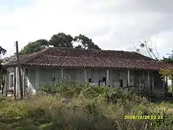 House of Marta Abreu | |
.png.webp) Encrucijada municipality (red) within Villa Clara Province (yellow) and Cuba | |
| Coordinates: 22°37′1″N 79°51′58″W | |
| Country | Cuba |
| Province | Villa Clara |
| Founded | 1850[1] |
| Established | 1910 (Municipality) |
| Area | |
| • Total | 345 km2 (133 sq mi) |
| Elevation | 55 m (180 ft) |
| Population (2004)[3] | |
| • Total | 33,641 |
| • Density | 97.5/km2 (253/sq mi) |
| Time zone | UTC-5 (EST) |
| Area code(s) | +53-422 |
History
The municipality was divided into the barrios of Centro, Paso Real, El Santo and Vega Redonda.[1] After the 1977 administrative reform, Calabazar de Sagua, part of Sagua la Grande, became part of it.
Geography
The municipality borders with Sagua la Grande, Cifuentes, Santa Clara and Camajuaní. It includes the villages of Arroyo Naranjo, Calabazar de Sagua, Constancia (Abel Santamaría), El Chivo, El Perico, El Purio (Perucho Figueredo), El Santo, Emilio Córdova, La Sierra, Piñón, Playa Nazabal, Playa Piñón and San Francisco.[4]
Demographics
In 2004, the municipality of Encrucijada had a population of 33,641.[3] With a total area of 345 km2 (133 sq mi),[2] it has a population density of 97.5/km2 (253/sq mi).
Notable people
- Onelio Jorge Cardoso (1914-1986), writer, born in Calabazar
- Jesús Menéndez Larrondo (1911-1948), trade unionist and politician
- Abel Santamaría Cuadrado (1927-1953), revolutionary
- Haydée Santamaría Cuadrado (1922-1980), revolutionary
References
- Guije.com. "Encrucijada" (in Spanish). Retrieved 2007-10-09.
- Statoids (July 2003). "Municipios of Cuba". Retrieved 2007-10-09.
- Atenas.cu (2004). "2004 Population trends, by Province and Municipality" (in Spanish). Archived from the original on 2006-07-14. Retrieved 2007-10-09.
- 5884794 Encrucijada on OpenStreetMap
External links
![]() Media related to Encrucijada at Wikimedia Commons
Media related to Encrucijada at Wikimedia Commons
Places adjacent to Encrucijada | ||||||||||
|---|---|---|---|---|---|---|---|---|---|---|
| ||||||||||
