Est, Netherlands
Est is a town in the Dutch province of Gelderland. It is a part of the municipality of West Betuwe, and lies about 8 km west of Tiel.
Est | |
|---|---|
Town | |
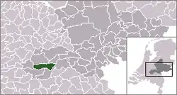 | |
 The town centre (red) and the statistical district (light green) of Est in the former municipality of Neerijnen. | |
| Coordinates: 51°51′9″N 5°18′49″E | |
| Country | Netherlands |
| Province | Gelderland |
| Municipality | West Betuwe |
| Area | |
| • Total | 0.065 km2 (0.025 sq mi) |
| Population (2018) | |
| • Total | 578 |
| • Density | 8,900/km2 (23,000/sq mi) |
| Time zone | UTC+1 (CET) |
| • Summer (DST) | UTC+2 (CEST) |
| Postal code | 4185 |
| Dialing code | 0345 |
In 2018, the town of Est had 578+ inhabitants. The built-up area of the town was 0.065 km², and contained 108 residences.[1] The statistical area "Est", which also can include the peripheral parts of the village, as well as the surrounding countryside, has a population of around 610.[2]
References
- Statistics Netherlands (CBS), Bevolkingskernen in Nederland 2001. (Statistics are for the continuous built-up area).
- Statistics Netherlands (CBS), Statline: Kerncijfers wijken en buurten 2003-2005 Archived 2006-07-24 at WebCite. As of 1 January 2005.
This article is issued from Wikipedia. The text is licensed under Creative Commons - Attribution - Sharealike. Additional terms may apply for the media files.