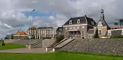
Tiel
Tiel (Dutch pronunciation: [til] (![]() listen)) is a municipality and a town in the middle of the Netherlands.
The town is enclosed by the Waal river and the Linge river on the south and the north side, and the Amsterdam-Rhine Canal on the east side. The city was founded in the 5th century AD.
listen)) is a municipality and a town in the middle of the Netherlands.
The town is enclosed by the Waal river and the Linge river on the south and the north side, and the Amsterdam-Rhine Canal on the east side. The city was founded in the 5th century AD.
Tiel | |
|---|---|
 Fortified dyke in Tiel | |
 Flag  Coat of arms | |
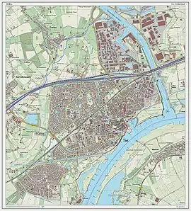
.svg.png.webp) Location in Gelderland | |
| Coordinates: 51°53′N 5°26′E | |
| Country | Netherlands |
| Province | Gelderland |
| Government | |
| • Body | Municipal council |
| • Mayor | Hans Beenakker (VVD) |
| Area | |
| • Total | 35.51 km2 (13.71 sq mi) |
| • Land | 32.88 km2 (12.70 sq mi) |
| • Water | 2.63 km2 (1.02 sq mi) |
| Elevation | 7 m (23 ft) |
| Population (January 2019)[4] | |
| • Total | 41,978 |
| • Density | 1,277/km2 (3,310/sq mi) |
| Demonym(s) | Tielenaar |
| Time zone | UTC+1 (CET) |
| • Summer (DST) | UTC+2 (CEST) |
| Postcode | 4000–4007, 4013–4014, 4017, 4062 |
| Area code | 0344 |
| Website | www |
Population centres
- Kapel-Avezaath
- Tiel
- Wadenoijen
The town of Tiel
Tiel is the largest town in the Betuwe area, which is famous for being one of the centres of Dutch fruit production. Orchards in the area produce apples, pears, plums and cherries. Tiel once housed the famous jam factory De Betuwe. After production was moved to Breda in 1993, the entire complex was demolished, although a part was reconstructed later. Reminding of this industry is a jam manufacturing museum and a statue of Flipje, the raspberry-based comic figure who starred in De Betuwe's, jam factory advertisements since the 1930s.
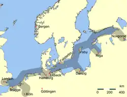
Tiel is one of the oldest towns in the Netherlands. Originally located on the Linge river it became an important centre of trade in the early Middle Ages, especially after the demise of Dorestad in the 9th century. Later in the Middle Ages Tiel was associated with the Hanseatic League. At the height of its glory Tiel had two big churches, one of which, the St. Walburg, was a collegiate church that belonged to the Teutonic Knights and vanished after the Reformation while the other church, the St. Maarten, became Protestant. Much of the historic centre was destroyed during the Second World War.
Every year, on the third Saturday in September, a festival known as 'Fruitcorso' is held to celebrate the fruit harvest from the Betuwe area. On this day, a parade of wagons, decorated with fruit, travels through the city, competing for the top three ranking. This top three is split in a 'normal' and a 'youth' category, with the wagons in the youth category featuring smaller wagons. Along the canal fruit mosaics are made by various organisations, also competing for a place in the top three. In the past, this event was accompanied by 'Appelpop', a free, two-day music event on the Waalkade. Due to Appelpop's popularity, Fruitcorso and Appelpop were split up, with Appelpop taking the second Friday and Saturday of September.
Tiel has also been known for its pewter industry. The last pewter factory cum museum, which mainly produced collectibles for tourists, went bankrupt in early 2004, but has since been revived. Tiel can be a good starting point to explore the rest of the scenic Betuwe area, particularly in May when all the fruit trees in the surrounding areas are in bloom.
Demographics
Residents as of 2010:[5]
- 78.4% both parents born in the Netherlands.
- 8.2% other European
- 13.4% non-European, including:
- 5.2% Turkish
- 4.3% Moroccan
- 0.6% Surinamese
- 0.5% Netherlands Antilles and Aruba
- 2.7% Others.
Notable residents
Public thinking & Public Service
- Joan van der Capellen tot den Pol (1741–1784) statesman, active in the Batavian Republic
- David Hendrik Chassé (1765–1849) a Dutch soldier who fought both for and against Napoleon
- Theodoor Gerard van Lidth de Jeude (1788–1863) a Dutch physician, veterinarian and zoologist
- Antonie Frederik Jan Floris Jacob van Omphal (1788–1863) a Dutch lieutenant-general and extraordinary aide-de-camp to William III of the Netherlands
- Cornelis Pijnacker Hordijk (1847–1908) a Dutch jurist and politician, Governor-General of the Dutch East Indies 1888/1893
- William Hendriksen (1900–1982) a New Testament scholar and writer of Bible commentaries
- Ria Beckers (1938–2006) a Dutch politician, promoted organic farming and peace
- Marinus van IJzendoorn (born 1952) human development professor, co-leader of Generation R
The Arts
- Annie Foore (1847–1890) a Dutch-born writer who lived in Dutch East Indies
- Menno ter Braak (1902–1940) was a Dutch modernist author and polemicist, grew up in Tiel
- Mary Dresselhuys (1907–2004) a Dutch stage actress [6]
- Eylem Aladogan, Dutch Wiki (born 1975) a Dutch installation artist and sculptor
- Frans Duijts (born 1979) a Dutch singer
- Abdellah Dami (born 1982) a Moroccan-Dutch journalist, presenter and writer
Sport
- Herman Claudius van Riemsdijk (born 1948) a Brazilian chess player
- Jan van Deinsen (born 1953) a retired Dutch football player with 276 club caps
- Nico Rienks (born 1962) a former rower, two-time gold medallist at the 1988 and 1996 Summer Olympics
- Anton Janssen (born 1963) a retired Dutch football player with 510 club caps
- Wilma van Velsen (born 1964) swimmer and team bronze and silver medallist in the 1980 and 1984 Summer Olympics
- Dirk Jan Derksen (born 1972) a retired Dutch football player with 464 club caps
- Bobbie Traksel (born 1981) a Dutch former professional racing cyclist
- Erik Pieters (born 1988) football player with 350 club caps
- Barry Maguire (born 1989) an Irish/Dutch football player with 250 club caps,
Gallery
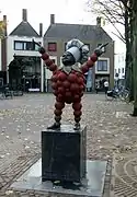 Statue of Flipje in Tiel
 Tiel, church: Sint Maartenskerk
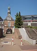 Town gate: Waterpoort
 Tiel, Appelpop on the Waalkade, Tiel
 Jewish Monument, Tiel
References
- "Burgemeester en wethouders" [Mayor and aldermen] (in Dutch). Gemeente Tiel. Retrieved 16 June 2014.
- "Kerncijfers wijken en buurten 2020" [Key figures for neighbourhoods 2020]. StatLine (in Dutch). CBS. 24 July 2020. Retrieved 19 September 2020.
- "Postcodetool for 4001MV". Actueel Hoogtebestand Nederland (in Dutch). Het Waterschapshuis. Retrieved 16 June 2014.
- "Bevolkingsontwikkeling; regio per maand" [Population growth; regions per month]. CBS Statline (in Dutch). CBS. 1 January 2019. Retrieved 1 January 2019.
- "Niet-westerse allochtonen per gemeente 2010-2040 - Nationale Atlas Volksgezondheid". Zorgatlas.nl. 2010-12-03. Retrieved 2012-03-28.
- IMDb Database retrieved 23 December 2019
External links
 Media related to Tiel at Wikimedia Commons
 Tiel travel guide from Wikivoyage
- Official website
Places adjacent to Tiel | |
|---|---|
Members of the Hanseatic League by quarter | |||||
|---|---|---|---|---|---|
| |||||
| Wendish |
|   | |||
| Saxon | |||||
| Baltic | |||||
| Westphalian | |||||
| Kontore |
| ||||
| Other cities | |||||

| Authority control |
|---|