Eureka Roadhouse, Alaska
Eureka Roadhouse is a census-designated place (CDP) in the Matanuska-Susitna Borough in the U.S. state of Alaska. It is part of the Anchorage, Alaska Metropolitan Statistical Area. The population was 29 at the 2010 census.
Eureka Roadhouse, Alaska | |
|---|---|
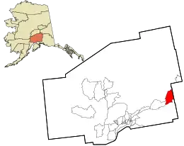 Location in Matanuska-Susitna Borough and the state of Alaska. | |
 Eureka Roadhouse, Alaska Location within the state of Alaska | |
| Coordinates: 61°57′53″N 147°9′6″W | |
| Country | United States |
| State | Alaska |
| Borough | Matanuska-Susitna |
| Government | |
| • Borough mayor | Vern Halter |
| • State senator | Mike Dunleavy (R) |
| • State rep. | George Rauscher (R) [1] |
| Area | |
| • Total | 187.9 sq mi (486.7 km2) |
| • Land | 186.4 sq mi (482.8 km2) |
| • Water | 1.5 sq mi (3.9 km2) |
| Elevation | 3,287 ft (1,002 m) |
| Population (2010) | |
| • Total | 29 |
| • Density | 0.15/sq mi (0.06/km2) |
| Time zone | UTC-9 (Alaska (AKST)) |
| • Summer (DST) | UTC-8 (AKDT) |
| ZIP Code | 99588, 99674 |
| Area code(s) | 907 |
Geography
Eureka roadhouse is located between the CPDs of Glacier View and Mendeltna on Alaska Route 1, North of the Chugach Mountains and southeast of the Talkeetna Mountains. The northern part of the CDP is occupied by the Nelchina Public Use Area.
It is 122 miles (196 km) from Anchorage by road.
According to the United States Census Bureau, the CDP has a total area of 187.9 sq. miles (486.7 km2), of which, 186.4 sq. miles (99.2%) of it is land and 1.5 sq. miles (0.8%) is water.[2]
Demographics
As of the census of 2010, there were 29 people, 16 households, and 6 families residing in the CDP. The population density was 0.15 people per square mile (0.06/km2). The racial makeup of the CDP was 22 (75.86%) White, 0 (0.0%) Black or African American, 2 (6.9%) Native American, 1 (3.4%) Asian, 0 (0.0%) from other races, and 4 (13.8%) from two or more races. 2 (6.9%) of the population were Hispanic or Latino of any race.
There were 101 housing units, of which 16 were occupied. Of the 16 households, 3 (18.8%) had children under the age of 18 living with them, 5 (31.3%) were married couples living together, 1 (6.3%) had a female householder with no husband present, and 10 (62.5%) were non-families. 9 (56.3%) of all households were made up of individuals, and 6 (35.5%) had someone living alone who was 65 years of age or older. The average household size was 1.81 and the average family size was 2.83.
In the CDP, the population was spread out, with 5 (17.1%) under the age of 18, 2 (6.9%) from 18 to 24, 3 (10.2%) from 25 to 44, 11 (37.8%) from 45 to 64, and 8 (27.5%) who were 65 years of age or older. The median age was 53.3 years. For every 100 females, there were 222.2 males (20 males, 9 females). For every 100 females age 18 and over, there were 200 males (16 adult males, 8 adult females).[3][4]
Income data was not present for Eureka Roadhouse.
References
- "Archived copy" (PDF). Archived from the original (PDF) on 2016-11-18. Retrieved 2016-10-01.CS1 maint: archived copy as title (link)
- "Eureka Roadhouse, Alaska :: Boundary Map of Eureka Roadhouse, Alaska". www.maptechnica.com. Archived from the original on 2016-10-03. Retrieved 2016-10-01.
- "U.S. Census website". United States Census Bureau. Retrieved 2016-10-01.
- http://censusviewer.com/city/AK/Eureka%20Roadhouse
Municipalities and communities of Matanuska-Susitna Borough, Alaska, United States | ||
|---|---|---|
| Cities | 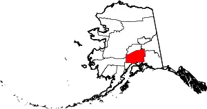 Matanuska-Susitna Borough map | |
| CDPs | ||
| Unincorporated communities |
| |
| ||