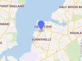
Farm Cove, New Zealand
The suburb of Farm Cove is located in eastern Auckland, New Zealand. The suburb is in the Howick ward, one of the thirteen administrative divisions of Auckland city.
Farm Cove | |
|---|---|
Suburb | |

| |
| Country | New Zealand |
| Local authority | Auckland City |
| Electoral ward | Howick Ward |
| Local board | Howick Local Board |
| Population (2018) | |
| • Total | 2,583 |
| Point England | Tamaki River | Half Moon Bay |
| Tamaki |
|
Pakuranga |
| Tamaki River | Sunnyhills | Highland Park |
The Rotary Walkway Reserve runs through Farm Cove.
Demographics
| Year | Pop. | ±% p.a. |
|---|---|---|
| 2006 | 2,472 | — |
| 2013 | 2,508 | +0.21% |
| 2018 | 2,583 | +0.59% |
| Source: [1] | ||
Farm Cove had a population of 2,583 at the 2018 New Zealand census, an increase of 75 people (3.0%) since the 2013 census, and an increase of 111 people (4.5%) since the 2006 census. There were 846 households. There were 1,233 males and 1,350 females, giving a sex ratio of 0.91 males per female. The median age was 43.1 years, with 492 people (19.0%) aged under 15 years, 453 (17.5%) aged 15 to 29, 1,182 (45.8%) aged 30 to 64, and 456 (17.7%) aged 65 or older.
Ethnicities were 67.6% European/Pākehā, 5.0% Māori, 2.7% Pacific peoples, 30.2% Asian, and 2.9% other ethnicities (totals add to more than 100% since people could identify with multiple ethnicities).
The proportion of people born overseas was 37.4%, compared with 27.1% nationally.
Although some people objected to giving their religion, 49.8% had no religion, 38.0% were Christian, and 7.2% had other religions.
Of those at least 15 years old, 699 (33.4%) people had a bachelor or higher degree, and 204 (9.8%) people had no formal qualifications. The median income was $39,400. The employment status of those at least 15 was that 984 (47.1%) people were employed full-time, 330 (15.8%) were part-time, and 57 (2.7%) were unemployed.[1]
Education
Farm Cove Intermediate is an intermediate school (years 7-8) with a roll of 618.[2] Wakaaranga School is a contributing primary school (years 1-6) with a roll of 704.[3] The name means "The resting place of the canoe".[4] The schools are both coeducational and are on adjacent sites. Rolls are as of March 2020.[5] There is also a small public kindergarten, located behind Wakaaranga Primary school.
Shops
There is a small shopping centre, Farm Cove Shopping Centre, which includes a dairy, hairdresser, bakery, and language school.
References
- "Statistical area 1 dataset for 2018 Census". Statistics New Zealand. March 2020. Farm Cove (148400). 2018 Census place summary: Farm Cove
- Education Counts: Farm Cove Intermediate
- Education Counts: Wakaaranga School
- "Our History". Wakaaranga School. Retrieved 22 August 2020.
- "New Zealand Schools Directory". New Zealand Ministry of Education. Retrieved 26 April 2020.
External links
- Photographs of Farm Cove held in Auckland Libraries' heritage collections.