Pakuranga
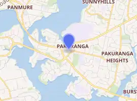
Pakuranga is a south-eastern suburb of Auckland, in northern New Zealand. Pakuranga covers a series of low ridges and previously swampy flats, now drained, that lie between the Pakuranga Creek and Tamaki River, two estuarial arms of the Hauraki Gulf. It is located to the north of Manukau and 15 kilometres southeast of the Auckland CBD.
Pakuranga | |
|---|---|
Suburb | |
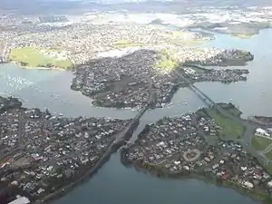 Pakuranga, looking east (the suburb is the "peninsula"-shape on the far side of the Tamaki River) | |
| |
| Country | New Zealand |
| Local authority | Auckland Council |
| Electoral ward | Howick Ward |
| Local board | Howick Local Board |
| Population (2018) | |
| • Total | 7,689 |
| (Tamaki River), Panmure | (Tamaki River), Glen Innes | Sunnyhills |
| (Tamaki River), Mount Wellington |
|
Pakuranga Heights |
| (Tamaki River), Ōtāhuhu | (Tamaki River) | East Tāmaki |
History
The suburb's name is Te Pakūranga-rā-hihi, Māori for battle of the sunlight or battle of the sun's rays. A fierce battle over forbidden love raged between two patupaiarehe - fairy people of the forest - until a priest caused the sun to rise and the earth to explode. Caught by the rays of the sun and volcanic eruptions, many patupaiarehe perished.[1]
Pakuranga is traditionally home to the Ngāi Tai Iwi also known as Ngāi Tai ki Tāmaki. The prominent pā were at Ohuiarangi / Pigeon Mountain and Mokoia Pā of Ngāti Paoa at Panmure on a cliff, at the intersection of the Te Wai Ō Taiki / Tamaki River and the inlet to the Panmure Basin. During the attacks by Ngapuhi in the Musket wars in late September 1820, most of the population were killed, taken prisoner or fled south to the Waikato.
In early European times, it was a sparsely settled dairy farming area between the townships of Panmure and Howick.[2] In the 1920s and 30s it was served by a bus that ran from Bucklands Beach known as the "shiek". In the 1930s a concrete road was built between these townships that improved transport times for people and milk. Although there had been a hinged steel bridge over the Tamaki River to Panmure from as early as 1866, it was not until the construction of a sturdier structure across the Tamaki River in the 1950s, coinciding with a demand for more settlement land[2] and the increasing levels of car ownership, that Pakuranga became suburban. In the 70s it was considered the typical New Zealand middle class suburb, 'Vim Valley', after 'a typical Pakuranga housewife' was featured in a famous cleaning product ad.[2]
Many of the American style houses of the 1950s and 1960s are still noticeable but much of the appeal of the early suburb lay in the proximity of untouched countryside. Since the 1970s Pakuranga has been surrounded and engulfed by suburban developments on a much larger scale but of less architectural merit. Traffic travelling to and from these suburbs and the centre of Auckland is largely funnelled through the roadways of Pakuranga which has degraded the area somewhat as well.
Despite this today Pakuranga remains an attractive suburb, with some light industry, centred on the Pakuranga Town Centre 1965, the second built in New Zealand, now known as "The Plaza". The mall is the second mall of the modern age in New Zealand, incorporating Farmers and George Court department stores.[3] The mall itself has been transformed several times since it first went up and retains little of the 1960s style it once had. The Te Tuhi Centre for the Arts is located nearby.[4]
Demographics
| Year | Pop. | ±% p.a. |
|---|---|---|
| 2006 | 6,576 | — |
| 2013 | 7,245 | +1.39% |
| 2018 | 7,689 | +1.20% |
| Source: [5] | ||
Pakuranga, comprising the statistical areas of Pakuranga West and Pakuranga Central, had a population of 7,689 at the 2018 New Zealand census, an increase of 444 people (6.1%) since the 2013 census, and an increase of 1,113 people (16.9%) since the 2006 census. There were 2,418 households. There were 3,798 males and 3,888 females, giving a sex ratio of 0.98 males per female, with 1,521 people (19.8%) aged under 15 years, 1,719 (22.4%) aged 15 to 29, 3,411 (44.4%) aged 30 to 64, and 1,035 (13.5%) aged 65 or older.
Ethnicities were 44.4% European/Pākehā, 11.7% Māori, 13.2% Pacific peoples, 41.4% Asian, and 3.6% other ethnicities (totals add to more than 100% since people could identify with multiple ethnicities).
The proportion of people born overseas was 48.0%, compared with 27.1% nationally.
Although some people objected to giving their religion, 40.9% had no religion, 37.2% were Christian, and 16.4% had other religions.
Of those at least 15 years old, 1,494 (24.2%) people had a bachelor or higher degree, and 993 (16.1%) people had no formal qualifications. The employment status of those at least 15 was that 3,225 (52.3%) people were employed full-time, 774 (12.5%) were part-time, and 213 (3.5%) were unemployed.[5]
Economy
Pakuranga Plaza
Pakuranga Plaza was established in 1965.[6] It covers 28,000 m² with 1400 carparks.[7] The plaza has 70 retailers, including Farmers, Countdown and The Warehouse.[8]
Schools
There was no school in the area before the 1960s so children had to walk or ride horses to the old Howick school which was located across from the Highland Park shops. The old school was moved to the old village display in Bells Rd, Pakuranga.
Edgewater College is a secondary school (years 9-13) with a roll of 618 students.[9]
Pakuranga Intermediate is an intermediate school (years 7–8) with a roll of 272 students.[10]
Anchorage Park School and Riverina School are contributing primary schools (years 1–6) with rolls of 145 and 116 students, respectively.[11][12]
Saint Kentigern College is a private Presbyterian secondary school (years 7-13) with a roll of 2154 students.[13]
All these schools are coeducational. Rolls are as of March 2020.[14]
See also
References
- "Auckland - Pakuranga". The Band Of Her Majesty's Royal Marines. Retrieved 7 January 2011.
- "Pakuranga". Te Ara: The Encyclopedia of New Zealand. Ministry for Culture and Heritage / Te Manatū Taonga. Retrieved 7 January 2011.
- "New Zealand's main malls". Te Ara: The Encyclopedia of New Zealand. Ministry for Culture and Heritage / Te Manatū Taonga. Retrieved 7 January 2011.
- "New lease for Te Tuhi arts centre - Centre's future guaranteed". Our Auckland. Auckland Council. 2 October 2019.
- "Statistical area 1 dataset for 2018 Census". Statistics New Zealand. March 2020. Pakuranga West (149000) and Pakuranga Central (149800). 2018 Census place summary: Pakuranga West 2018 Census place summary: Pakuranga Central
- "Auckland places - East Auckland". Te Ara: The Encyclopedia of New Zealand. Ministry for Culture and Heritage.
- "Pakuranga Plaza". gypproperties.com. GYP Properties.
- "Pakuranga Plaza Directory". pakurangaplaza.co.nz. GYP Properties.
- Education Counts: Edgewater College
- Education Counts: Pakuranga Intermediate
- Education Counts: Anchorage Park School
- Education Counts: Riverina School
- Education Counts: Saint Kentigern College
- "New Zealand Schools Directory". New Zealand Ministry of Education. Retrieved 26 April 2020.
External links
- History of Howick and Pakuranga
- Google Map of Pakuranga
- Te Tuhi Centre for the Arts
- Photographs of Pakuranga held in Auckland Libraries' heritage collections.