Farm to Market Road 122
Farm to Market Road 122 (FM 122) is a short farm-to-market road in Ralls, Texas.[1]
| ||||
|---|---|---|---|---|
| ||||
| Route information | ||||
| Length | 0.130 mi[1] (0.209 km) | |||
| Existed | 1967–present | |||
| Major junctions | ||||
| West end | ||||
| East end | Avenue G in Ralls | |||
| Location | ||||
| Counties | Crosby | |||
| Highway system | ||||
| ||||

Route description
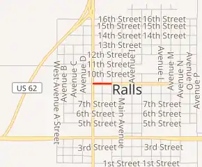
The western terminus of FM 122 is at an intersection with SH 207. The route travels east along Tilford Avenue.[1] The FM 122 designation and state maintenance end at an intersection with Avenue G; at this point, the roadway turns from pavement to brick. FM 122 is the shortest Farm to Market Road, as TxDOT's mileage length at 0.13 miles is shorter than that of FM 742 (which is 0.175 miles).[2][3]
History
FM 122 was designated on February 28, 1945 from US 82 at Ralls south to Caprock as a replacement of a section of State Highway 207. On June 11, 1945 a section from Post north 8 miles was added, creating a gap. This gap was closed on February 25, 1949 when the road was extended into Garza County. On July 31, 1956 the road was extended north to the new location of US 62. On October 31, 1958 a spur was added in Ralls. This spur is all that remains of FM 122 as FM 122 from US 62 to Post was reassigned back to SH 207 on September 1, 1965, though signage did not change until November 1, 1968.
Major intersections
The entire route is in Ralls, Crosby County.
| mi[3] | km | Destinations | Notes | ||
|---|---|---|---|---|---|
| 0.0 | 0.0 | Western terminus | |||
| 0.1 | 0.16 | Avenue G | Eastern terminus; state maintenance ends | ||
| 1.000 mi = 1.609 km; 1.000 km = 0.621 mi | |||||
References
- Transportation Planning and Programming Division (n.d.). "Farm to Market Road No. 122". Highway Designation Files. Texas Department of Transportation. Retrieved January 3, 2011.
- Transportation Planning and Programming Division (2014). Texas County Mapbook (PDF) (Map) (2014 ed.). 1:120,000. Texas Department of Transportation. p. 151. Retrieved December 6, 2014.
- Google (January 5, 2011). "Overview map of Farm to Market Road 122 Distances Between Interchanges" (Map). Google Maps. Google. Retrieved January 5, 2011.