Farringdon, Sunderland
Farringdon is a suburb of Sunderland, Tyne and Wear, England. Originally a Monastic grange and manor estate for hundreds of years, Farringdon was rebuilt as a post-war council housing estate in the 1950s. It is approximately 3 miles south of the city centre along the A690, close to Thorney Close, Silksworth, East Herrington, Gilley Law and Doxford Park. Electorally, the area comes under the St. Chad's ward of the City.
| Farringdon | |
|---|---|
 Farringdon in 2020 looking towards the sea | |
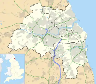 Farringdon Location within Tyne and Wear | |
| Population | 5,100 |
| Metropolitan borough | |
| Metropolitan county | |
| Region | |
| Country | England |
| Sovereign state | United Kingdom |
| Post town | SUNDERLAND |
| Postcode district | SR3 |
| Police | Northumbria |
| Fire | Tyne and Wear |
| Ambulance | North East |
| UK Parliament | |
History
Recorded human activity on Farringdon has been dated back to the Neolithic era, with a stone axe being uncovered during construction work in the 1950s.[1]
The current settlement has its origin as a block Demesne in the Middle Ages, being a hamlet and estate within the parish of Bishopwearmouth and the township of Silksworth during the late Middle Ages.[2]
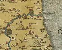
In the 14th century the area was associated with the Blakiston family.[3] The etymology of the name appears to derive from: "Farm or hill of Faer or his sons"[4] although it nevertheless had a variety of spellings throughout this period including Farnton Hall, Farrington Hall, Ffaernton and Ferenton Hall. By the 15th century, it served as a Monastic Grange of the priory of Hexham.[5][6][7]
In the 1420s, the land was represented by Robert Jackson who served as baliff of Sunderland and collected taxes on behalf of the Bishop of Durham.[8][9][10] By 1479 the Black Book of Hexham detailed the area as possessing cottage lands, a Windmill, an oven and brewery[11][12] A New Manor was built on the land in 1597, which had disappeared by the mid 20th century.[13]
The estate passed through various landowners throughout the ages, including John Forster (soldier), George Blakiston and the Pepper family of North Yorkshire.[14][15]
The manor estate and farm would exist upon the land up until the mid 20th century, whereby the land was purchased by Sunderland County Borough Council and transformed into a post-war housing state, complete with two schools and shopping arcades. By the end of the 20th century, many of the homes on the estate had been privately purchased through the right to buy scheme.
In the mid 19th century, the Hetton Colliery Railway, one of the first operational railways in History and the first of its kind to transport coal, passed through Farringdon and Gilley Law en route to the River Wear. Maps show that a former station existed on what is now the site of the school, a subsequent walking path remains.
Facilities and schools in Farringdon

Farringdon contains a large secondary school (Farringdon Community Academy), and a primary school (Farringdon Primary School). The area was originally host to a police station which closed in 2015, the site remains empty. A fire station remains present. The area possesses three shopping arcades and a single pub known as The Dolphin, which has been voted Sunderland's "pub of the year" for five years running.[16] The former Farringdon Social Club closed in 2017 and is now being redeveloped into a business park.[17]
Also in Farringdon is the Jubilee Centre, a community centre offering activities and learning opportunities for people in the area a McDonald's, and two residential homes for the elderly.
Politics
Farringdon is a component of the St. Chad's Ward in the city alongside parts of Herrington. Presently, the area is represented by two councillors from the Conservative Party (UK) and one from the Labour Party (UK).
Street naming convention
All street names in Farringdon begin with the letter A. The main street running through the centre of the estate is Allendale Road. Other streets include Archer Road, Avonmouth Road, Aldwych Road, Aldwych Square, Abercorn Road, Arbroath Road, Antwerp Road, Arkle Road, Aboyne Square, Archer Square, Andrew Road.
References
- Morrison, Jennifer. "Tyne and Wear HER(222): Farringdon, polished axe - Details". Sitelines. Tyne and Wear Archaeology Office. Retrieved 11 December 2020.
- Blair, Hunter (2014). The Open Fields of England. Oxford: Oxford University Press. p. 102. ISBN 9780198702955.
- Blair, Hunter (1939). Archaeologia Aeliana, Or, Miscellaneous Tracts Relating to Antiquity. Newcastle Upon Tyne: Society of Antiquaries of Newcastle-upon-Tyne. p. 190.
- Summers, Jeremiah William (1858). "The History and Antiquities of Sunderland, Bishopwearmouth, Bishopwearmouth Panns, Burdon ...: From the Earliest Authentic Records Down to the Present Time".
- Morrison, Jennifer. "Tyne and Wear HER(222): Farringdon monastic grange - Details". Sitelines. Tyne and Wear Archaeology Office. Retrieved 9 December 2020.
- Echo, Sunderland (6 January 1950). British Newspaper Archive. Sunderland Echo https://www.britishnewspaperarchive.co.uk/viewer/bl/0000640/19500106/101/0007. Retrieved 14 December 2020. Missing or empty
|title=(help) - Clarkson, Christopher (1821). "The History of Richmond, in the County of York".
- Gillan, Tony (3 December 2019). "See inside the Sunderland Echo Pub of the Year 2019 winner". Sunderland Echo. Sunderland Echo. Retrieved 14 December 2020.
- Binding, Chris (3 December 2019). "Former Sunderland social club set to become business park with cafes, takeaways and shops after housing plans fall through". Sunderland Echo. Sunderland Echo. Retrieved 16 January 2020.