Fehring
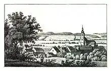
Fehring is a municipality in the district of Südoststeiermark in Styria, Austria. The landscape is rolling hills cut by the valley of the Raab. Fehring is on a socket some metres above the valley floor. The town is bordered to the east by Burgenland.
Fehring | |
|---|---|
 | |
 Coat of arms | |
 Fehring Location within Austria | |
| Coordinates: 46°56′00″N 16°01′00″E | |
| Country | Austria |
| State | Styria |
| District | Südoststeiermark |
| Government | |
| • Mayor | Johann Winkelmaier (ÖVP) |
| Area | |
| • Total | 87.08 km2 (33.62 sq mi) |
| Elevation | 272 m (892 ft) |
| Population (2018-01-01)[2] | |
| • Total | 7,284 |
| • Density | 84/km2 (220/sq mi) |
| Time zone | UTC+1 (CET) |
| • Summer (DST) | UTC+2 (CEST) |
| Postal code | 8350 |
| Area code | +43 3155 |
| Vehicle registration | FB |
| Website | www.fehring.at |


Neighbouring municipalities
- In the north: Johnsdorf-Brunn and Hohenbrugg-Weinberg
- In the east: Sankt Martin an der Raab and Mühldorf
- In the south: Kapfenstein
- In the west: Pertlstein
Community structure
The municipality Fehring consists of the villages Hirtzenrigel, Höflach, Petzelsdorf, Petersdorf and Schiefer.
History
The first mention of Fehring is with 40 homesteads in a document from Ottokar of 1265th. The district Petzelsdorf is already mentioned in the Babenberger Urbar 1220th. Fehring was founded as a marketplace and Rudolf IV, Duke of Austria awarded the market law. A parish has been documented in Fehring since 1305.
There have been a lot of wars and fights around Fehring, therefore a tabor was built in the 15th century.
Transportation
Fehring railway station is the terminus for S3 services from Graz on the Steirische Ostbahn.
Coat of arms
King Ferdinand granted arms in Augsburg at 8 July 1550.
Twin towns
References
- "Dauersiedlungsraum der Gemeinden Politischen Bezirke und Bundesländer - Gebietsstand 1.1.2018". Statistics Austria. Retrieved 10 March 2019.
- "Einwohnerzahl 1.1.2018 nach Gemeinden mit Status, Gebietsstand 1.1.2018". Statistics Austria. Retrieved 9 March 2019.