Flattnitz Pass
Flattnitz Pass (el. 1400 m.) is a high mountain pass in the Austrian Alps.
| Flattnitz Pass | |
|---|---|
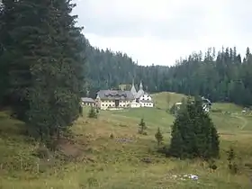 Panoramic view, with St John's Church | |
| Elevation | 1,400 m (4,593 ft) |
| Traversed by | L63 |
| Location | Carinthia, Austria |
| Range | Gurktal Alps |
| Coordinates | 46°56′31″N 14°2′7″E |
 Flattnitz Pass Location of Flattnitz Pass | |
The pass is located in the state of Carinthia, connecting Glödnitz in the Gurk valley with Stadl on the Mur river, beyond the border with Styria. The pass height comprises a dispersed settlement with a high-altitude sanatorium (Luftkurort) and an Alpine lake (Flattnitzer See). It is a popular destination for hikers and for cross-country skiers in winter.
_18.jpg.webp)
The pass was possibly known in Roman times, it was first mentioned in an 898 deed issued by the Carolingian emperor Arnulf. In 1173 the Gurk bishops had a Romanesque chapel erected, dedicated to St John the Baptist, which was rebuilt as a parish church with an adjacent hospice building about 1330. The bishops used Flattnitz (from Slovene: blato, "moss") as a summer residence. The pass height was devastated by invading Ottoman forces in 1478. In the 17th century, Flattnitz was a mining area for silver, iron ore, and lead.
External links
| ||
