Gurktal Alps
The Gurktal Alps (German: Gurktaler Alpen, Slovene: Krške Alpe) are a mountain range of the Central Eastern Alps in Austria, named after the valley of the Gurk River.
| Gurktal Alps | |
|---|---|
 Wöllaner Nock, 2,145 m (7,037 ft) | |
| Highest point | |
| Peak | Eisenhut |
| Elevation | 2,441 m (8,009 ft) |
| Coordinates | 46°57′11″N 13°55′45″E |
| Geography | |
| Country | Austria |
| States | Carinthia, Styria and Salzburg |
| Range coordinates | 46°57′N 13°56′E |
| Parent range | Central Eastern Alps Carinthian-Styrian Alps (Noric Alps) |
Geography
Location
The range is located between the Mur Valley in the north, separating it from the Niedere Tauern, and the Drava in the south, where it borders on the Gailtal Alps and Karavanke ranges of the Southern Limestone Alps. In the west, the Gurktal Alps reach up to the Katschberg Pass and the Ankogel Group of the Hohe Tauern range. In the east, the Neumarkt Pass in Upper Styria separates it from the adjacent Lavanttal Alps.
Subdivisions
The Gurktal Alps may be divided into five subgroups:
- The Nock Mountains lie between the Liesertal and Flattnitzer Höhe. Their highest peak is the Eisenhut (2,441 m).
- The Metnitz Mountains lie between the Mur and Metnitz valleys. Their highest point is the Goldachnock (2,171 m).
- The Mödring Chain lies between the Metnitz and Gurktal valleys. Its highest point is the Dorferecken (1,726 m)
- The Wimitz Mountains lie between the Gurk and Glan valleys through which flows the Wimitz river. Their highest peaks are the Schneebauerberg and the Hocheck (both 1,338 m)
At the southern end of the Gurktal Alps is the Klagenfurt Basin. Here there are seven more smaller mountain chains:
- Magdalensberg (Lippekogel, 1,079 m)
- Ossiach Tauern (Taubenbühel 1,069 m)
- Glantal Highlands (Ulrichsberg, 1,022 m)
- Sattnitz (Tanzboden, 929 m)
- Feldkirchen-Moosburg Upland (Freudenberg, 817 m)
- St. Veit Upland (Buchberg, 808 m)
- Maria Saal Upland (Maria Saaler Berg, 746 m)
Occasionally the Gurktal Alps, along with the Lavanttal Alps to the east, are classified as part of the Noric Alps, but that is not geologically justified.[1]
Peaks
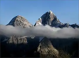
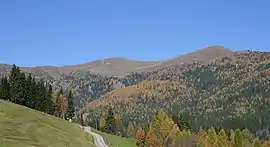
The highest peaks are located within the Nock Mountains (Nockberge, from Nock meaning "rounded hilltop", cf. Nockerl) subgroup west of Flattnitz Pass, including Mt. Eisenhut, 2,441 m (8,009 ft), in Styria. The Nationalpark Nockberge along the scenic Nockalm Road in Carinthia since 1987 is a protected landscape area (IUCN V). The Nock Mountains also stretch down to major Carinthian lakes like Millstätter See and Ossiacher See.
Other peaks include:
- Großer Rosennock, 2,440 m (8,010 ft)
- Hohe Pressing, 2,370 m (7,780 ft)
- Rinsennock, 2,334 m (7,657 ft)
Economy and tourism

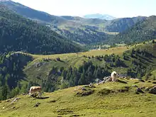
The gentle landscape with its numerous mountain pastures had been the site of transhumance agriculture since ancient times. The Gurktal Alps were also a mining area for iron and silver, still magnesite deposits are exploited near Radenthein.
Today tourism is the most important economic sector. The valleys of the Gurktal Alps cater for tourists in summer and for the busy winter season. The leading tourist area is Bad Kleinkirchheim, then Turracher Höhe (Predlitz-Turrach and Reichenau), Falkert (Reichenau) and Innerkrems (Krems in Kärnten), Flattnitz, Afritz and Katschberg (Rennweg am Katschberg). The largest ski areas are Katschberg-Aineck, Innerkrems-Schönfeld-Karneralm, Turracher Höhe and Gerlitzen in the Nock Mountains and Kreischberg in the Metnitz Mountains.
The region of the Nock Mountains is also well known for its healing spas. The Karlbad along the Nockalmstraße is the oldest farmers healing spring in Austria. The way in which the baths are made (with spring water and hot rocks), has remained unchanged since the 17th century. Their remote location means there is also no electricity. The name of the spa is derived from the little cirque (Karl from Kar, cirque).
References
- Norische Alpen in Austria-Forum (in German) (at AEIOU)