Flushing Avenue station (IND Crosstown Line)
Flushing Avenue is a station on the IND Crosstown Line of the New York City Subway. Located at the intersection of Flushing and Union/Marcy Avenues in the boundary of Bedford-Stuyvesant and Williamsburg, Brooklyn, it is served at all times by the G train.
Flushing Avenue | ||||||||||||||||||||||||||||||||||||||||||||||||||||||||||||||||||||
|---|---|---|---|---|---|---|---|---|---|---|---|---|---|---|---|---|---|---|---|---|---|---|---|---|---|---|---|---|---|---|---|---|---|---|---|---|---|---|---|---|---|---|---|---|---|---|---|---|---|---|---|---|---|---|---|---|---|---|---|---|---|---|---|---|---|---|---|---|
 Queens bound platform | ||||||||||||||||||||||||||||||||||||||||||||||||||||||||||||||||||||
| Station statistics | ||||||||||||||||||||||||||||||||||||||||||||||||||||||||||||||||||||
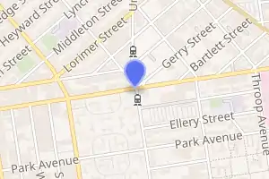
| Address | Flushing Avenue & Union Avenue Brooklyn, NY 11206 | |||||||||||||||||||||||||||||||||||||||||||||||||||||||||||||||||||
| Borough | Brooklyn | |||||||||||||||||||||||||||||||||||||||||||||||||||||||||||||||||||
| Locale | Bedford-Stuyvesant, Williamsburg | |||||||||||||||||||||||||||||||||||||||||||||||||||||||||||||||||||
| Coordinates | 40.699739°N 73.950176°W | |||||||||||||||||||||||||||||||||||||||||||||||||||||||||||||||||||
| Division | B (IND) | |||||||||||||||||||||||||||||||||||||||||||||||||||||||||||||||||||
| Line | IND Crosstown Line | |||||||||||||||||||||||||||||||||||||||||||||||||||||||||||||||||||
| Services | G | |||||||||||||||||||||||||||||||||||||||||||||||||||||||||||||||||||
| Transit | ||||||||||||||||||||||||||||||||||||||||||||||||||||||||||||||||||||
| Structure | Underground | |||||||||||||||||||||||||||||||||||||||||||||||||||||||||||||||||||
| Platforms | 2 side platforms | |||||||||||||||||||||||||||||||||||||||||||||||||||||||||||||||||||
| Tracks | 2 | |||||||||||||||||||||||||||||||||||||||||||||||||||||||||||||||||||
| Other information | ||||||||||||||||||||||||||||||||||||||||||||||||||||||||||||||||||||
| Opened | July 1, 1937[1] | |||||||||||||||||||||||||||||||||||||||||||||||||||||||||||||||||||
| Station code | 287[2] | |||||||||||||||||||||||||||||||||||||||||||||||||||||||||||||||||||
| Opposite- direction transfer | No | |||||||||||||||||||||||||||||||||||||||||||||||||||||||||||||||||||
| Traffic | ||||||||||||||||||||||||||||||||||||||||||||||||||||||||||||||||||||
| 2019 | 732,897[3] | |||||||||||||||||||||||||||||||||||||||||||||||||||||||||||||||||||
| Rank | 390 out of 424[3] | |||||||||||||||||||||||||||||||||||||||||||||||||||||||||||||||||||
| Station succession | ||||||||||||||||||||||||||||||||||||||||||||||||||||||||||||||||||||
| Next north | Broadway: G | |||||||||||||||||||||||||||||||||||||||||||||||||||||||||||||||||||
| Next south | Myrtle–Willoughby Avenues: G | |||||||||||||||||||||||||||||||||||||||||||||||||||||||||||||||||||
| ||||||||||||||||||||||||||||||||||||||||||||||||||||||||||||||||||||
| ||||||||||||||||||||||||||||||||||||||||||||||||||||||||||||||||||||
| ||||||||||||||||||||||||||||||||||||||||||||||||||||||||||||||||||||
| ||||||||||||||||||||||||||||||||||||||||||||||||||||||||||||||||||||

History
This station opened on July 1, 1937, when the entire Crosstown Line was completed between Nassau Avenue and its connection to the IND Culver Line. On this date, the GG was extended in both directions to Smith–Ninth Streets and Forest Hills–71st Avenue.[1]
In 1984, after a series of robberies in the station, Pfizer, which has a plant located one block away from the station, installed four closed circuit TVs and talk-back boxes on the platforms, monitoring them from the Pfizer plant security area, reporting crimes to the local precinct and TA police. The installation was completed as part of the TA's Adopt-A-Station Program and cost $50,000. The TA added additional lighting in a stairwell and added an additional Off-Hours-Waiting Area. Shortly after the installation, several crimes were prevented.[4] As of 1990, the emergency system resulted in 14 arrests and 5 convictions. Pfizer also helped the MTA refurbish the Brooklyn-bound platform with high-entry turnstiles, security gates and new railings. New artwork was also added to the station.[5]
Under the 2015–2019 Metropolitan Transportation Authority Capital Program, this station, along with 32 others, would have undergone a complete overhaul as part of the Enhanced Station Initiative. Updates would have included cellular service, Wi-Fi, USB charging stations, interactive service advisories and maps, and improved signage and station lighting.[6][7] However, most of these renovations are being deferred until the 2020–2024 Capital Program due to a lack of funding.[8]
Station layout
| G | Street level | Entrances/exits |
| B1 | Mezzanine | Station agent, fare control, MetroCard machines |
| B2 Platform level |
Side platform | |
| Northbound | ← | |
| Southbound | | |
| Side platform | ||
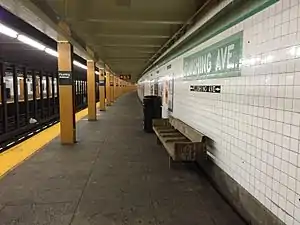
This underground station has two tracks and two side platforms.[9] Both platforms have a light green trim line on a dark green border and mosaic name tablets reading "FLUSHING AVE." in white sans serif lettering on a dark green background and light green border. Underneath the trim line and name tablets are tile captions and direction signs in white lettering on a black background. Yellow I-beams run along both platforms are regular intervals, alternating ones having the standard black station name plate with white lettering.
Exits
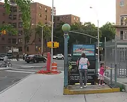
The platforms each have one same-level fare control area at their south ends and there are no crossovers or crossunders to allow a free transfer between directions. Each area has a turnstile bank, two full height turnstiles (one exit-only and the other high entry/exit), token booth, and one staircase to the street.[10] The one on the southbound side goes up to the southwest corner of Flushing and Marcy Avenues while the one on the Queens-bound side goes up to the northeast corner of Union Avenue (which becomes Marcy Avenue at the intersection of Flushing Avenue) and Gerry Street (which begins diagonally at the aforementioned intersection).[10][11] The turnstile bank and token booth on the southbound platform is only open on weekdays and the two full height turnstiles provide entrance to and exit from the station at other times.
The station formerly had another exit at the north end as proven by one gated staircase on each platform going up. Directional signs indicate that this mezzanine and crossover, which are now used for storage and employee space, led to both southern corners of Walton Street and Union Avenue. Both staircases were eventually sealed, and the one to the southwestern corner was partly demolished during the construction of new buildings.
References
- "New Crosstown Subway Line Is Opened". Brooklyn Daily Eagle. July 1, 1937. Retrieved December 24, 2015.
- "Station Developers' Information". Metropolitan Transportation Authority. Retrieved June 13, 2017.
- "Facts and Figures: Annual Subway Ridership 2014–2019". Metropolitan Transportation Authority. 2020. Retrieved May 26, 2020.
- Lalli, Alexia (September 21, 1984). "Memorandum Re: Briefing Memo - Flushing Avenue Adopt-A-Station Ceremony" (PDF). www.laguardiawagnerarchive.lagcc.cuny.edu. Metropolitan Transportation Authority. Retrieved March 4, 2019.
- Farrell, Bill (February 16, 1990). "G, doesn't the station look great!". New York Daily News. Retrieved March 8, 2019.
- "MTA Will Completely Close 30 Subway Stations For Months-Long "Revamp"". Gothamist. Archived from the original on August 1, 2016. Retrieved July 18, 2016.
- "MTAStations" (PDF). governor.ny.gov. Government of the State of New York. Retrieved July 18, 2016.
- Berger, Paul (April 3, 2018). "New York Subway Cuts Back Plans to Renovate Stations". Wall Street Journal. ISSN 0099-9660. Retrieved April 3, 2018.
- Dougherty, Peter (2020). Tracks of the New York City Subway 2020 (16th ed.). Dougherty. OCLC 1056711733.
- "Review of the G Line: Appendices" (PDF). Metropolitan Transportation Authority. July 10, 2013. Retrieved October 28, 2015.
- "MTA Neighborhood Maps: Williamsburg & Bedford-Stuyvesant" (PDF). Metropolitan Transportation Authority. 2015. Retrieved July 3, 2015.
External links
| Wikimedia Commons has media related to Flushing Avenue (IND Crosstown Line). |
- nycsubway.org – IND Crosstown: Flushing Avenue
- Station Reporter — G Train
- The Subway Nut — Flushing Avenue Pictures
- Flushing Avenue entrance from Google Maps Street View
- Platform from Google Maps Street View
Crosstown |
|
|---|---|
| |
| Crosstown Line |
|
|---|---|
| |