Fort Campbell (Malta)
Fort Campbell (Maltese: Forti Campbell or Fortizza ta' Campbell), also known locally as Il-Fortizza ta' Selmun,[1] is a former fort in Mellieħa, Malta. It was built by the British between 1937 and 1938. It is notable as the most important fortification north of the Victoria Lines, and the last major fortification to be built in Malta. Today, it lies in ruins.
| Fort Campbell | |
|---|---|
Forti Campbell | |
| Mellieħa, Malta | |
_04_ies.jpg.webp) Fort Campbell as viewed from the sea | |
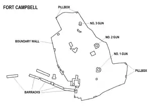
 Map of Fort Campbell | |
| Coordinates | 35°57′49.5″N 14°23′25.7″E |
| Type | Fort |
| Site information | |
| Owner | Government of Malta |
| Condition | Ruins |
| Site history | |
| Built | 1937–1938 |
| Built by | British Empire |
| In use | 1938–1970s |
| Materials | Limestone and concrete |
| Battles/wars | World War II |
History
Fort Campbell is located on the Selmun peninsula, roughly halfway between Mistra Battery and the ruins of Għajn Ħadid Tower, and facing St Paul's Islands. It was built to protect the approach to both Mellieħa Bay and St. Paul's Bay. It also protected British seaplanes which landed in Mistra Bay.[2] The fort took over the role of Wardija Battery, which had been built in 1915.[3]
Before construction of the fort began, Governor Charles Bonham-Carter visited the site. Work on the fort probably began in December 1937, and work was hurried after the Munich Agreement of September 1938.[4] The fort was modified throughout the course of World War II, when barracks were built and a radar was installed.
It is not known exactly when the fort was decommissioned. After the war, its strategic importance diminished and it was on the verge of being closed by 1949. However, the fort remained in military hands and a watchman remained stationed there until the 1970s.[5]
Layout

Fort Campbell is very different from earlier fortifications in Malta, such as the bastioned forts built by the Knights Hospitaller and the polygonal forts built by the British in the 19th century. Due to the new threat of aerial warfare, the fort was surrounded by a thin wall, and the buildings were placed at a distance from each other. Due to this, the fort was camouflaged as from the air it resembled the field walls of the surrounding countryside. Unlike many of the earlier fortifications, Fort Campbell was unadorned. For example, the fort's gateway is just a breach in the perimeter wall defended by a guard room, in contrast with the usually ornate gates of many Hospitaller or Victorian forts.[2]
Fort Campbell's design is similar to other fortifications built before and during World War II throughout the British Empire, such as Fort Stanley in Hong Kong, Good Head Battery in New Zealand, Brownstone Battery in Devon, and Fort South Sutor in Scotland.[2]

The fort had two gun emplacements which were armed with 6-inch BL guns. A third gun emplacement may have housed another 6-inch gun or a heavy anti-aircraft gun. In addition, a number of concrete machine gun posts (similar to pillboxes) and rifle loopholes were placed at irregular intervals around the perimeter wall. The buildings in the fort included Battery Observation Post, which served as the command post of the fort and had a gun control room and an underground plotting room. The fort also had direction posts, a water tank, underground magazines, a generator room and rock-hewn bomb shelters. Defence Electric Lights and searchlight emplacements were also built outside the perimeter wall on the shoreline.[2]
In 1942, barracks were built outside the fort to house the force of infantry that was stationed in Selmun. Various Nissen and Romney huts were also built inside and outside the fort.[2]
Present day

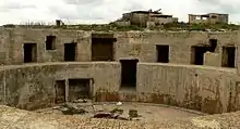
Since Fort Campbell was decommissioned, it has fallen into a state of neglect and disrepair. It still retains most of its original features, although many rooms are in ruins. The fort was vandalized repeatedly, and in 2004 the fire control position was completely destroyed by vandals.[6] At some point, the iron beams that supported the roof of the barracks were stolen, and due to this some of the blocks have collapsed or are in danger of collapsing. Since the fort is abandoned, it is possible to enter, but parts of it are dangerous to visitors.[7]
The mayor of the Mellieħa Local Council, Robert Cutajar, is attempting to restore the fort.[5] Until now, the site was never restored since it would be very expensive given the large area of the fort. It has been proposed that the site be rehabilitated as a picnic or camping site. In 2014, Prime Minister Joseph Muscat stated that the government intends to rehabilitate the fort and the surrounding area.[8]
Further reading
- Sammut, Jeffrey (6 January 2019). "Bren Gun Carriers, bridges and ditches" (PDF). The Sunday Times of Malta. pp. 56–57.
References
| Wikimedia Commons has media related to Fort Campbell (Malta). |
- Camilleri, Alex (2011). "It-Toponomastika ta' Malta: Il-Mellieħa u Madwarha" (PDF). L-Imnara (in Maltese). Għaqda tal-Folklor. 9 (4): 196. Archived from the original (PDF) on 17 April 2016.
- Mifsud, Simon (14 September 2012). "Fort Campbell". MilitaryArchitecture.com. Archived from the original on 15 November 2015. Retrieved 15 March 2015.
- Spiteri, Stephen C. (2004–2007). "A general overview of the fortifications in the locality of Mellieha" (PDF). Arx – Online Journal of Military Architecture and Fortification (1–4): 44. Archived from the original (PDF) on 15 November 2015. Retrieved 14 November 2015.
- Debono, Charles. "Fortifications – Fort Campbell (Selmun)". Mellieha.com. Retrieved 15 March 2015.
- "Fort Campbell Facing its biggest threat ever". The Malta Independent. 22 September 2012. Retrieved 15 March 2015.
- "Historic fort attacked again". Times of Malta. 31 March 2004. Retrieved 15 March 2015.
- "Selmun Peninsula". iluvmalta.com. Retrieved 15 March 2015.
- "Government intends to rehabilitate Fort Campbell". Times of Malta. 1 December 2014. Retrieved 15 March 2015.