Fort Green, Florida
Fort Green is an unincorporated community and census-designated place (CDP) in Hardee County, Florida, United States. Its population was 101 as of the 2010 census.[1]
Fort Green, Florida | |
|---|---|
 Fort Green  Fort Green | |
| Coordinates: 27°36′45″N 81°56′36″W | |
| Country | United States |
| State | Florida |
| County | Hardee |
| Area | |
| • Total | 4.042 sq mi (10.47 km2) |
| • Land | 4.042 sq mi (10.47 km2) |
| • Water | 0 sq mi (0 km2) |
| Elevation | 115 ft (35 m) |
| Population | |
| • Total | 101 |
| • Density | 25/sq mi (9.6/km2) |
| Time zone | UTC-5 (Eastern (EST)) |
| • Summer (DST) | UTC-4 (EDT) |
| Area code(s) | 863 |
| GNIS feature ID | 294776[2] |
Geography
Fort Green is in northwestern Hardee County, bordered to the north by Polk County and to the south by Fort Green Springs. Brewster Road is the main road through the community, leading south 1 mile (1.6 km) to State Road 62 in Fort Green Springs and north 13 miles (21 km) to State Road 37 at Bradley Junction. Fort Green is 12 miles (19 km) northwest of Wauchula, the Hardee County seat.
According to the U.S. Census Bureau, the Fort Green CDP has an area of 4.042 square miles (10.47 km2), all of it land.[1] Payne Creek, an east-flowing tributary of the Peace River, forms the southern border of the CDP.
References
- "2010 Census Gazetteer Files - Places: Florida". U.S. Census Bureau. Retrieved March 26, 2017.
- "Fort Green". Geographic Names Information System. United States Geological Survey.
Municipalities and communities of Hardee County, Florida, United States | ||
|---|---|---|
| Cities | 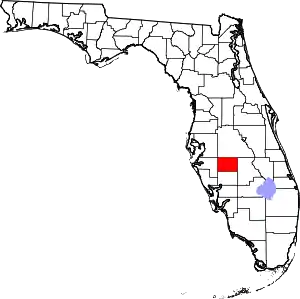 | |
| Town | ||
| CDPs | ||
| Unincorporated communities | ||
| Ghost town | ||
| ||
