Frýdštejn
Frýdštejn (German: Friedstein) is a municipality and village in Jablonec nad Nisou District in the Liberec Region of the Czech Republic. It has about 900 inhabitants.
Frýdštejn | |
|---|---|
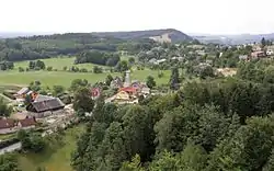 Frýdštejn seen from the Frýdštejn Castle | |
 Flag  Coat of arms | |
 Frýdštejn Location in the Czech Republic | |
| Coordinates: 50°39′8″N 15°9′32″E | |
| Country | |
| Region | Liberec |
| District | Jablonec nad Nisou |
| First mentioned | 1385 |
| Area | |
| • Total | 14.49 km2 (5.59 sq mi) |
| Elevation | 474 m (1,555 ft) |
| Population (2020-01-01[1]) | |
| • Total | 853 |
| • Density | 59/km2 (150/sq mi) |
| Time zone | UTC+1 (CET) |
| • Summer (DST) | UTC+2 (CEST) |
| Postal code | 468 31, 468 32 |
| Website | www |
Administrative parts
Villages and hamlets of Anděl Strážce, Bezděčín, Borek, Horky, Kaškovice, Ondříkovice, Roudný, Sestroňovice, Slapy and Voděrady are administrative parts of Frýdštejn.
Geography
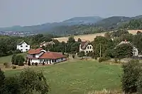
Living houses at the Bezděčínský stream
The highest point of the municipality is the Kopanina Hill (657 m).
History
The first written mention of Frýdštejn is from 1385.[2]
Sights
- Ruins of the Frýdštejn Castle
- Observation tower on the Kopanina Hill
- Rock town Drábovna
References
- "Population of Municipalities – 1 January 2020". Czech Statistical Office. 2020-04-30.
- "Historie". Obec Frýdštejn. Retrieved 2021-02-07.
| Wikimedia Commons has media related to Frýdštejn. |
| Authority control |
|
|---|
This article is issued from Wikipedia. The text is licensed under Creative Commons - Attribution - Sharealike. Additional terms may apply for the media files.