Francesville, Indiana
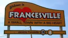
Francesville is a town in Salem Township, Pulaski County, in the U.S. state of Indiana.[6] The population was 879 at the 2010 census. The motto for Francesville is “A small town with a big heart.”[7]
Francesville, Indiana | |
|---|---|
| Town of Francesville | |
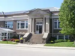 Francesville Library | |
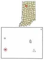 Location of Francesville in Pulaski County, Indiana. | |
| Coordinates: 40°59′9″N 86°53′2″W | |
| Country | United States |
| State | Indiana |
| County | Pulaski |
| Township | Salem |
| Area | |
| • Total | 0.30 sq mi (0.79 km2) |
| • Land | 0.30 sq mi (0.79 km2) |
| • Water | 0.00 sq mi (0.00 km2) |
| Elevation | 679 ft (207 m) |
| Population | |
| • Total | 879 |
| • Estimate (2019)[4] | 797 |
| • Density | 2,621.71/sq mi (1,013.64/km2) |
| Time zone | UTC-5 (EST) |
| • Summer (DST) | UTC-5 (EST) |
| ZIP code | 47946 |
| Area code(s) | 219 |
| FIPS code | 18-25288[5] |
| GNIS feature ID | 434752 |
History
.jpg.webp)
Francesville was founded in 1853 when the railroad was extended to that point.[8] The town was named for Frances Brooks, the daughter of a railroad official.[8] A post office has been in operation at Francesville since 1853.[9]
Mallon Building was listed on the National Register of Historic Places in 1999.[10]
Geography
According to the 2010 census, Francesville has a total area of 0.3 square miles (0.78 km2), all land.[11]
Demographics
| Historical population | |||
|---|---|---|---|
| Census | Pop. | %± | |
| 1860 | 189 | — | |
| 1870 | 281 | 48.7% | |
| 1880 | 368 | 31.0% | |
| 1890 | 403 | 9.5% | |
| 1900 | 596 | 47.9% | |
| 1910 | 729 | 22.3% | |
| 1920 | 648 | −11.1% | |
| 1930 | 712 | 9.9% | |
| 1940 | 804 | 12.9% | |
| 1950 | 856 | 6.5% | |
| 1960 | 1,002 | 17.1% | |
| 1970 | 1,015 | 1.3% | |
| 1980 | 944 | −7.0% | |
| 1990 | 969 | 2.6% | |
| 2000 | 905 | −6.6% | |
| 2010 | 879 | −2.9% | |
| 2019 (est.) | 797 | [4] | −9.3% |
| U.S. Decennial Census[12] | |||
2010 census
As of the census[3] of 2010, there were 879 people, 353 households, and 259 families living in the town. The population density was 2,930.0 inhabitants per square mile (1,131.3/km2). There were 384 housing units at an average density of 1,280.0 per square mile (494.2/km2). The racial makeup of the town was 97.0% White, 0.2% African American, 0.7% Native American, 0.1% Asian, 0.3% from other races, and 1.6% from two or more races. Hispanic or Latino of any race were 3.6% of the population.
There were 353 households, of which 33.1% had children under the age of 18 living with them, 56.9% were married couples living together, 11.9% had a female householder with no husband present, 4.5% had a male householder with no wife present, and 26.6% were non-families. 24.6% of all households were made up of individuals, and 12.5% had someone living alone who was 65 years of age or older. The average household size was 2.49 and the average family size was 2.91.
The median age in the town was 39.6 years. 26.1% of residents were under the age of 18; 7% were between the ages of 18 and 24; 23.6% were from 25 to 44; 27% were from 45 to 64; and 16.4% were 65 years of age or older. The gender makeup of the town was 49.3% male and 50.7% female.
2000 census
As of the census[5] of 2000, there were 905 people, 357 households, and 252 families living in the town. The population density was 2,954.7 people per square mile (1,127.2/km2). There were 383 housing units at an average density of 1,250.4 per square mile (477.0/km2). The racial makeup of the town was 97.68% White, 0.11% African American, 0.22% Asian, 0.33% from other races, and 1.66% from two or more races. Hispanic or Latino of any race were 1.33% of the population.
There were 357 households, out of which 33.9% had children under the age of 18 living with them, 59.7% were married couples living together, 7.8% had a female householder with no husband present, and 29.4% were non-families. 26.3% of all households were made up of individuals, and 13.4% had someone living alone who was 65 years of age or older. The average household size was 2.54 and the average family size was 3.09.
In the town, the population was spread out, with 27.5% under the age of 18, 6.6% from 18 to 24, 27.4% from 25 to 44, 20.4% from 45 to 64, and 18.0% who were 65 years of age or older. The median age was 37 years. For every 100 females, there were 94.6 males. For every 100 females age 18 and over, there were 91.3 males.
The median income for a household in the town was $39,464, and the median income for a family was $43,438. Males had a median income of $30,000 versus $20,341 for females. The per capita income for the town was $16,469. About 3.3% of families and 4.2% of the population were below the poverty line, including 2.2% of those under age 18 and 2.8% of those age 65 or over.
Education
The town has a lending library, the Francesville-Salem Township Public Library.[13]
References
- "2019 U.S. Gazetteer Files". United States Census Bureau. Retrieved July 16, 2020.
- "US Board on Geographic Names". United States Geological Survey. 2007-10-25. Retrieved 2008-01-31.
- "U.S. Census website". United States Census Bureau. Retrieved 2012-12-11.
- "Population and Housing Unit Estimates". United States Census Bureau. May 24, 2020. Retrieved May 27, 2020.
- "U.S. Census website". United States Census Bureau. Retrieved 2008-01-31.
- "Francesville, Indiana". Geographic Names Information System. United States Geological Survey. Retrieved 2017-04-01.
- "Francesville, Indiana". Francesville, Indiana. Retrieved 2020-02-04.
- "Francesville". Pulaski County, Indiana. Retrieved 24 November 2015.
- "Pulaski County". Jim Forte Postal History. Retrieved 24 November 2015.
- "National Register Information System". National Register of Historic Places. National Park Service. July 9, 2010.
- "G001 - Geographic Identifiers - 2010 Census Summary File 1". United States Census Bureau. Archived from the original on 2020-02-13. Retrieved 2015-07-16.
- "Census of Population and Housing". Census.gov. Retrieved June 4, 2015.
- "Indiana public library directory" (PDF). Indiana State Library. Retrieved 14 March 2018.
Municipalities and communities of Pulaski County, Indiana, United States | ||
|---|---|---|
| Towns | Map of Indiana highlighting Pulaski County | |
| Townships | ||
| CDP | ||
| Other unincorporated communities | ||
| ||
| Authority control |
|
|---|