Franz Ludwig Güssefeld
Franz Ludwig Güssefeld (6 December 1744 – 17 June 1807) was a German cartographer. He is noted for his highly accurate maps which were mostly published by Homannsche Erben ("Homann Heirs") in Nuremberg.
Franz Ludwig Güssefeld | |
|---|---|
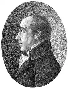 Portrait of Güssefeld published in 1808 | |
| Born | 6 December 1744 |
| Died | 17 June 1807 (aged 62) |
| Nationality | German |
| Occupation | surveyor, cartographer, engineer, forester |
| Known for | Maps published by Homann Heirs |
| Spouse(s) | Johanna Christiana Brunquel (1744–1807) |
Biography
Güssefeld was born in Osterburg and already had an interest in drawing and creating maps in his youth.[1] When he failed to secure a position with the Prussian Corps of Engineers, he became a forester.
His 1773 map of Brandenburg was the first of over a 100 maps of his that were published by Homann Heirs.[2] The high quality of Güssefeld's work is credited with saving Homann Heirs, a formerly famous publisher which before Güssefeld's arrival had been in an increasingly difficult position due to mismanagement.[2]
During the final 18 years of his life, the Landes-Industrie Comptoir and Geographisches Institut von Bertuch in Weimar also published some of Güssefeld's maps. Güssefeld died of pulmonary edema in Weimar in 1807.[1]
Gallery
 United States (1784)
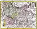 Lower Saxony (1786)
_cropped.jpg.webp) Africa (1797)
Africa (1797) Asia (1805)
References
- Bertuch, Friedrich Justin (1808). Allgemeine geographische Ephemeriden, Band 26. Weimar. pp. 255–262.
- Seifert, Traudl, „Güssefeld, Franz Ludwig“, in: Neue Deutsche Biographie 7 (1966), S. 289 [Onlinefassung]; http://www.deutsche-biographie.de/pnd12196695X.html
External links
 Media related to Franz Ludwig Güssefeld at Wikimedia Commons
| Authority control |
|
|---|
