Gailingen am Hochrhein
Gailingen am Hochrhein is a village in the district of Konstanz in Baden-Württemberg, in southern Germany.
Gailingen am Hochrhein | |
|---|---|
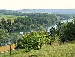 Rhine at Gailingen | |
 Coat of arms | |
Location of Gailingen am Hochrhein within Konstanz district  | |
 Gailingen am Hochrhein  Gailingen am Hochrhein | |
| Coordinates: 47°41′49″N 8°45′18″E | |
| Country | Germany |
| State | Baden-Württemberg |
| Admin. region | Freiburg |
| District | Konstanz |
| Government | |
| • Mayor | Heinz Brennenstuhl |
| Area | |
| • Total | 13.17 km2 (5.08 sq mi) |
| Elevation | 469 m (1,539 ft) |
| Population (2019-12-31)[1] | |
| • Total | 2,915 |
| • Density | 220/km2 (570/sq mi) |
| Time zone | UTC+01:00 (CET) |
| • Summer (DST) | UTC+02:00 (CEST) |
| Postal codes | 78262 |
| Dialling codes | 07734 |
| Vehicle registration | KN |
| Website | www.gailingen.de |
It is situated in a southernmost part of the region called Hegau in a unique location on the northern bank of the High Rhine just across the border from Switzerland and close to Lake Constance. The population currently numbers 3,070.
History
Founded over 1,000 years ago, Gailingen was first mentioned in a document in 965. However the village probably dates back to the 5th century when the Alamanni settled in the area. The name “Gailingen” literally refers to “the people of Geilo,” one of the Alamanni leaders.
In the 11th century, a family of noblemen owned the area and probably erected a castle on the Rauhenberg mountain. This castle is long gone but left its name on that part of the mountain. In the 14th century, ownership was transferred to the former noble family of Randegg, which left its sign of a lion's head in the village's shield.
The village changed hands numerous times in the course of the following centuries. In 1540, the neighbouring city of Schaffhausen (in Switzerland) purchased one third of the domain; the other parts were owned by several families, with the Liebenfels family being responsible for the construction of a small castle called “Liebenfelsisches Schloesschen” in 1750.
In the mid-17th century, Gailingen became the home of several Jewish families and gradually became one of the largest Jewish communities in the south of Germany. They built a synagogue, school, hospital and old people's home, and their population reached a number almost as high as that of the non-Jewish population. In 1870, the village elected its first Jewish mayor. Seven years later both Jewish and non-Jewish children were attending the same school. Members of both faiths were living together peacefully until Hitler's rise to power. In October 1940 over 200 Jews from Gailingen were rounded up from their homes to be deported to France.
Infrastructure
In 1950, Gailingen am Hochrhein became the seat for a rehabilitation clinic and in 1972, a second one specifically addressing young people followed. A new church and a new school were built as well. What used to be a largely agricultural village is now a modern one, catering for tourists from all over the world. Due to its location, clean air and peaceful surroundings, Gailingen was awarded the title “national health resort” in 1977.
Südbadenbus serves the village with a bus connection to Büsingen am Hochrhein which is a small exclave belonging to Germany. The bus passes through Swiss territory to reach the main village of Büsingen as well as the small outlying settlement Stemmer.
References
- "Bevölkerung nach Nationalität und Geschlecht am 31. Dezember 2019". Statistisches Landesamt Baden-Württemberg (in German). September 2020.
Towns and municipalities in Konstanz (district) | ||
|---|---|---|
Coat of arms of Landkreis Konstanz | ||
| Authority control |
|---|