Aach, Baden-Württemberg
Aach | |
|---|---|
 | |
 Coat of arms | |
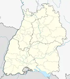
Location of Aach within Konstanz district  | |
 Aach  Aach | |
| Coordinates: 47°50′44″N 8°51′6″E | |
| Country | Germany |
| State | Baden-Württemberg |
| Admin. region | Freiburg |
| District | Konstanz |
| Government | |
| • Mayor | Severin Graf (CDU) |
| Area | |
| • Total | 10.69 km2 (4.13 sq mi) |
| Elevation | 545 m (1,788 ft) |
| Population (2019-12-31)[1] | |
| • Total | 2,295 |
| • Density | 210/km2 (560/sq mi) |
| Time zone | UTC+01:00 (CET) |
| • Summer (DST) | UTC+02:00 (CEST) |
| Postal codes | 78267 |
| Dialling codes | 07774 |
| Vehicle registration | KN |
| Website | www.aach.de |
Lordship of Aach Herrschaft Aach | |||||||||
|---|---|---|---|---|---|---|---|---|---|
| before 1100 – 1805 | |||||||||
| Status | Lordship | ||||||||
| Capital | Aach | ||||||||
| Common languages | Low Alemannic | ||||||||
| Government | Lordship | ||||||||
| Historical era | Middle Ages | ||||||||
before 1100 10th century | |||||||||
1283 | |||||||||
| 1499 | |||||||||
• Occupied: German Peasants' War | 1525 | ||||||||
• Ravaged during French Revolutionary Wars | March 25, 1799 | ||||||||
| 1805 | |||||||||
| |||||||||
Aach (German pronunciation: [ˈaːx] (![]() listen)) is a small town in the German state of Baden-Württemberg (the region of Hegau). Being situated close to Lake Constance and the Swiss border, it is mostly known for the Aachtopf — Germany's biggest natural spring in terms of production.
listen)) is a small town in the German state of Baden-Württemberg (the region of Hegau). Being situated close to Lake Constance and the Swiss border, it is mostly known for the Aachtopf — Germany's biggest natural spring in terms of production.
History
Aach was first mentioned in the year 1100. By the year 1150 the settlement was known in Latin as Oppidum Ach in Hegovia. Aach was granted town rights in 1283 by King Rudolph I of Germany. For the next centuries it was a part of Further Austria.
In 1499 battles of the Swabian War took place right before gates of Aach. Only 26 years later, in 1525, the German Peasants' War reached Aach, when region's aristocrats flew from the uprisings to the city, whereupon it was occupied by the rebel peasants. However, the uprisings were thrown down quickly by September 1525.
On March 25, 1799, there was a battle in Aach between Austria and France in the Napoleonic Wars. After Austria's defeat in the Third Coalition 1805, Aach came to the Grand Duchy of Baden, which joined the German Empire in 1871.
After World War II Aach became a part of the new (West) German state of Baden-Württemberg.
Law and government

Aach has formed a cooperation with the nearby City of Engen sharing some of its administrative domains.
Aach has a city council with twelve seats. The last elections in 2004 brought three seats for the CDU, three seats for the SPD and four seats for independent voters' associations. Aach's mayor is Manfred Ossola.
Geography
Aach is situated at the edge of the Hegau — a volcanic landscape between Lake Constance and the Swabian Alb mountains. The German–Swiss border lies about 14 km to the southeast.
Jewish History
The first record of Jews in Aach is dated to 1518, in which the Jews of nearby Geisingen were accused of murdering a Christian child, an incident that can be considered a Blood libel. Every ten years, the local Jews were required to renew their residence permits. Between 1560 and 1570, five Jewish families resided in the town. Jews could host a maximum of five guests. They were required to notify the authorities upon the arrival of a Jewish visitor, and he could not trade with the local townspeople. In 1583, residence rights, now truncated to five-year increments, were renewed for Aach's six Jewish families. Additional restrictions were imposed on the town Jews, forbidding them to deal with agricultural products, and chant at the synagogue.[2]
References
- "Bevölkerung nach Nationalität und Geschlecht am 31. Dezember 2019". Statistisches Landesamt Baden-Württemberg (in German). September 2020.
- Richard Gottheil. "AACH". Jewish Encylocpedia. Retrieved 17 February 2020.
External links
- (in German) Aach:History and images