Gamo Gofa Zone
Gamo is a Zone in the Ethiopian Southern Nations, Nationalities, and Peoples' Region (SNNPR). It is named for whose homelands lie in this Zone. Gamo is bordered on the south by the Dirashe special woreda, on the southwest by Debub (South) Omo and the Basketo special woreda, on the northwest by Konta special woreda, on the north by Dawro and Wolayita, on the northeast by the Lake Abaya which separates it from the Oromia Region, and on the southeast by the Amaro special woreda. The administrative center of Gamo is Arba Minch.
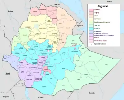
Gamo has 431 kilometers of all-weather roads and 122 kilometers of dry-weather roads, for an average road density of 45 kilometers per 1000 square kilometers.[1] The highest point in this Zone is Mount Gughe (4,207 meters above sea level). The Lake Chamo is located at the southeastern part of Gamo just south of Lake Abaya. The Nechisar National Park is located between these two lakes.
Originally Gamo was part of the Semien (North) Omo Zone, and the 1994 national census counted its inhabitants as part of that Zone. However friction between the various ethnic groups in Semien Omo, which was often blamed on the Welayta for "ethnic chauvinism" and despite the efforts of the ruling party to emphasize the need to co-ordinate, consolidate, and unify the smaller ethnic units to achieve the "efficient use of scarce government resources", eventually led to the division of the Zone in 2000, resulting with the creation of not only the Gamo Gofa, but also the Dawro and Wolayita Zones and two special woredas.[2]
Demographics

Based on the 2007 Census conducted by the Central Statistical Agency of Ethiopia (CSA), this Zone has a total population of 1659310 of whom 779332 are men and 879782 women; with an area of 18,010.99 square kilometers, Gamo Gofa has a population density of 144.68. While 157,446 or 9.88% are urban inhabitants, a further 480 or 0.03% are pastoralists. A total of 337,199 households were counted in this Zone, which results in an average of 4.72 persons to a household, and 324,919 housing units. The largest ethnic groups reported in this Zone included the Gamo (64.61%), the Gofa (22.08%), the Oyda (2.35%), the Amhara (2.32%), the Welayta (1.91%), and the Basketo (1.38%); all other ethnic groups made up 5.35% of the population. Gamo is spoken as a first language by 63.75% of the inhabitants, 22.01% Gofa, 3.47% Amharic, 2.31% Basketo, 1.83% Oyda, and 1.74% Welayta; the remaining 4.89% spoke all other primary languages reported. 53.41% of the population said they were Protestants, 31.54% practiced Ethiopian Orthodox Christianity, and 11.13% observed traditional religions.[3]
Woredas
- Arba Minch Town
- Arba Minch Zuria
- Bonke
- Boreda
- Chencha
- Demba Gofa
- Dita
- Deramalo
- Geze Gofa
- Kemba
- Kucha
- Melokoza
- Mirab Abaya
- Oyda
- Sawla Town
- Uba Debretsehay
- Zala
- Geresse woreda
- Gacho Baba woreda
- Kogota Woreda
Former woredas are:
References
- "Detailed statistics on roads" Archived July 20, 2011, at the Wayback Machine, SNNPR Bureau of Finance and Economic Development website (accessed 3 September 2009)
- Sarah Vaughan, "Ethnicity and Power in Ethiopia" Archived August 13, 2011, at the Wayback Machine (University of Edinburgh: Ph.D. Thesis, 2003), pp. 251 - 260
- Census 2007 Tables: Southern Nations, Nationalities, and Peoples' Region Archived November 13, 2012, at the Wayback Machine, Tables 2.1, 2.4, 2.5, 3.1, 3.2 and 3.4.
- Schröder, Günter (2017). Federal Democratic Republic of Ethiopia Administrative Divisions: Regions (kilil), Zones, Districts (wereda) (Report). Frankfurt.
- Desalegn Kebede Kaza, The Enforcement of Rights of Gamo People of Ethiopia: An Approach for Indigenous People's Self-Determined Development
| Current zones |  | |
|---|---|---|
| Former zones | ||
| Special woredas | ||
Woredas of the Gamo Gofa Zone | ||
|---|---|---|
| Former woredas | ||
| Current woredas | ||