Wolayita Zone
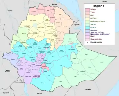
Wolayita is an administrative zone in the Southern Nations, Nationalities, and Peoples' Region (SNNPR) of Ethiopia. It is named for the Welayta people, whose homeland is in the zone. Wolayita is bordered on the south by Gamo Gofa, on the west by the Omo River which separates it from Dawro, on the northwest by Kembata Tembaro, on the north by Hadiya, on the northeast by the Oromia Region, on the east by the Bilate River which separates it from Sidama, and on the south east by the Lake Abaya which separates it from Oromia Region. The administrative centre of Wolayita is Sodo. Other major towns are Bedessa, Areka, Dimtu, Gesuba, Tebela Town, Bitena and Boditi.[1]
Wolayita has 358 kilometres of all-weather roads and 425 kilometres of dry-weather roads, for an average road density of 187 kilometres per 1000 square kilometres.[2] Its highest point is Mount Damota (2738 meters).
History
Originally Wolayita was part of the Semien (North) Omo Zone, and the 1994 national census counted its inhabitants as part of that zone. However friction between the various ethnic groups in Semien Omo, which was often blamed on the Welayta for "ethnic chauvinism" and despite the efforts of the ruling party to emphasise the need to co-ordinate, consolidate, and unify the smaller ethnic units to achieve the "efficient use of scarce government resources", eventually led to the division of the zone in 2000, resulting in the creation of not only the Wolayita, but also the Gamo Gofa and Dawro Zones and two special woredas.[3]
In May and December 2019 rallies were held in Wolayita in support of the zone separating from the Southern Nations, Nationalities, and Peoples' Region to become a region in its own right. A rally on 20 December 2019, oppose the failure of the regional council to send a request of the zone to become a regional state to the National Board of Election to arrange a referendum.[4] The Sidama Zone separated from the SNNPR to become the Sidama Region in 2020, following a referendum in November 2019.
Geography
Wolayta is one of the 16 Zonal Administrations of the Southern Region In Ethiopia, located 300 kilometers south of Addis Ababa.
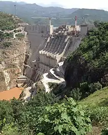
Wolayta is limited north west by Tambaro, eastward by Bilate river which divides it from Arsi-Oromo, Southward by Lake Abaya and Kucha, westward by Omo River. Gilgel Gibe III Dam is a hydroelectric power plant built on Omo river; and with the capacity of 1870 Megawatt, it is the third largest hydroelectric plant in Africa.
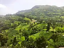
The vegetation and very comfortable climate of the large part of the region are conditioned by an overall elevation of between 1,500 and 1,800 meters above the sea level. There are, however, five mountains higher than 2,000 meters, with Mount Damota - at 3,000 meters - at the center.
Through mildly undulating hills, one can travel through the whole area with out difficulty, there are no Large forests except in the Soddo Zuriya, and Omo river basin, which is well below 1500 meters and a malaria zone.
In the local view, there are only two regions: the highlands (Geziyaa) and the lowlands (Garaa). In the highlands, there are numerous streams and small rivers. Several thermal hot springs are situated around Lake Abaya, with boiling and steaming water which is believed to cure diseases. The ajora waterfalls are a majestic scene of the wilderness, like damota precipices.
The soil of the Wolayta is of heavy red color which becomes brown and black during the rains and has the fragility and the softness of sand. The dry period makes the soil hard as brick, one reason why people can plough and dig only after the rains. One can hardly find any stone except on the river banks, whose soil is light and easy to excavate. The layer of soil is very deep—an average of 30 meters—in both the plains and the hills, as verified during the drilling of wells. The soil is very fertile and produce two crops per year when the rains are regular.
Climate
The climate is stable, with temperature variation between 24 and 30 °C during the day and 16 to 20 °C at night, all year round. The dry, temperate heat makes the climate simply "delicious".[5]
The year is divided into two seasons: the wet season (balguwa) from June to October, and the dry season (boniya) from October to June, broken in February by a short period of so-called “little rains” (baddessa). The average rainfall for the entire region is 1350 millimeters per year.[6]
The dry season is characterized by a strong wind which blows from the east; the sky is absolutely blue and rarely crossed by small white clouds. At night the sky is so transparent that it seems to hold twice the number of stars as in European or American skies.
During the heavy seasons, heavy precipitation and violent storms which, at the end of the season can last a full evening or night are common events.
Fog can be seen in the valleys almost every morning of the rainy season; it then evaporates in the first hours of the sun.
In both seasons either hail which destroys crops or tornadoes, which knock down trees, are possible events.
Demographics
Based on the 2007 Census conducted by the Central Statistical Agency of Ethiopia (CSA), the zone has a total population of 5,473,190; with an area of 4,208.64 square kilometers, Wolayita has a population density of 356.67. While 172,514 or 11.49% are urban inhabitants, a further 1,196 or 0.08% are pastoralists. A total of 310,454 households were counted in the zone, which results in an average of 4.84 persons to a household, and 297,981 housing units. The largest ethnic group reported in the zone is the Welayta (96.31%); all other ethnic groups made up 3.69% of the population. Welayta is spoken as a first language by 96.82% of the inhabitants; the remaining 3.18% spoke all other primary languages reported. 71.34% were Protestants, 21% of the population said they practiced Ethiopian Orthodox Christianity, and 5.35% embraced Catholicism.[7]
.jpg.webp)
| Number | Woredas | Administrative town |
|---|---|---|
| 1 | Abala Abaya | Paracho |
| 2 | Boloso Bombe | Bombe 01 |
| 3 | Boloso Sore | Areka |
| 4 | Damot Gale | Boditi |
| 5 | Damot Pulasa | Shanto |
| 6 | Damot Sore | Gununo |
| 7 | Damot Weyde | Bedessa |
| 8 | Diguna Fango | Bitena |
| 9 | Hobicha | Hobicha Bada |
| 10 | Humbo | TebelaTown |
| 11 | Bayra Koysha. | Bekilo Segno |
| 12 | Kindo Didaye | Halale |
| 13 | Kindo Koysha | Bale |
| 14 | Kawo Koysha | Lasho |
| 15 | Offa | Gesuba |
| 16 | Sodo zuriya | Sodo |
Economy
Agriculture is the livelihood for more than 90% of the population in the rural areas. Animal husbandry is complementary to crop production, and the livestock population of Wolayita with estimated standing populations of 685,886 cattle, 87,525 sheep, 90,215 goats, 1951 horses, 669,822 poultry and 38,564 bee hives.[8] Mixed farming involving the production of cereals, root crops, Ensete, and coffee are practiced. Ensete is an essential element in Wolayita food economy and acts as a staple, or co-staple, food. Where land is very scarce and consequently where cereal harvests are low, high yielding Enset offers some opportunity for food security. Enset is also popular because of its drought resistant properties.
Flora
For a visitor coming from the north by the shashemene-Arbaminch road or through the Addis-Hosanna Road, through the Arid dusty savanna sparsely covered by thorny plants, or from the south through the hilly and mountainous territory of Gammo, the Wolayta zone appears like a paradise (wanderheym 1896:162).
The vegetation is abundant through the year with eucalyptus, pines, acacia, magnolias, fire trees, and enormous sycamores mingled with false banana (Utta).
Grass, at the end of the rainy season, can be as high as three meters. The variety of trees and colors make the region very impressive, and all travelers comment on its beauty (Leontief 1900:292; Du Bourg 1906; Pascal de luchon, March 29, 1930, and December 25, 1937).
Du Bourg wrote enthusiastically about Wolayta: “The indications of the richness are abundant all around the villages: large fields of cereal surround them, and above all, the large cotton plantations.
Here is the cotton country, the country where the Ethiopian mantles are prepared, where this plant grows, which together, with the coffee is the source of the present Ethiopian wealth and which will become the great product of the exportation in the near future.
“Maize, wheat, durra, barley, and teff are cultivated all over the area...for many of them can reap two harvests per year” (gaslini 1940:986).
All Mediterranean trees grow and bear fruit: grapes, apples, pears, peaches, apricots, oranges, tangerines, bananas, papayas, avocados, etc. –with impressive production all year round.
There are no forests, but a great variety of non-indigenous trees in the region: bamboo, eucalyptus, and euphorbia grow naturally in steep and arid soil and are used for fire and the milky liquid is used as a poison.
Greatly appreciated are the fern, because of its resistance to termites and the wild olive. A softer tree (ochiyaa), with leaves like the olive, is used for fences and domestic purposes.
The most appreciated of all is the very hard wood of the (gassa) which is heavy and strong as iron. Its wood is made into the long sticks used for tilling because it can penetrate the most arid soil.
Sugar cane and a light fibrous wood (kaytariya or deshsha loomiyaa) are used as tooth brush culturally; a pleasant smelling wood (susungiyaa) is used in coffee, and the aromatic (natra) is added to butter for cosmetics. Many kinds of mushrooms are used either alone or mixed with raw meat.
References
- "21_adm_snp_081517_a0" (PDF). Reliefweb.int. Retrieved 6 October 2020.
- "Detailed statistics on roads", SNNPR Bureau of Finance and Economic Development website (accessed 3 September 2009)
- Sarah Vaughan, "Ethnicity and Power in Ethiopia" (University of Edinburgh: Ph.D. Thesis, 2003), pp. 251–260
- "Wolaita zone admits boycotting SEPDM CC meeting". Addis Standard. 18 July 2019. Retrieved 22 November 2020.
- Hodson 1970:33
- WADU 1977-1978:table 1
- Census 2007 Tables: Southern Nations, Nationalities, and Peoples' Region, Tables 2.1, 2.4, 2.5, 3.1, 3.2 and 3.4.
- , CSA, 2003. Central statistical authority. Livestock Population of Ethiopia,
| Current zones |  | |
|---|---|---|
| Former zones | ||
| Special woredas | ||