Gas, Kansas
Gas is a city in the northwestern part of Allen County, located in southeast Kansas, in the Central United States. As of the 2010 census, the city population was 564.[7] The city was named for the abundant natural gas that was found in the area.[8]
Gas, Kansas | |
|---|---|
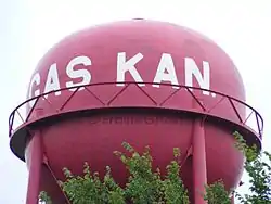 "Gas Kan"- shaped Watertower in Gas (2012) | |
| Motto(s): "Don't Pass Gas, Stop and Enjoy It"[1] | |
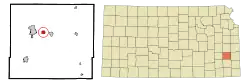 Location within Allen County and Kansas | |
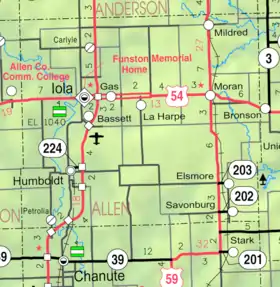 KDOT map of Allen County (legend) | |
| Coordinates: 37°55′26″N 95°20′46″W | |
| Country | United States |
| State | Kansas |
| County | Allen |
| Township | Elm |
| Area | |
| • Total | 0.72 sq mi (1.87 km2) |
| • Land | 0.72 sq mi (1.86 km2) |
| • Water | 0.00 sq mi (0.00 km2) |
| Elevation | 1,024 ft (312 m) |
| Population | |
| • Total | 564 |
| • Estimate (2019)[4] | 501 |
| • Density | 695.83/sq mi (268.78/km2) |
| Time zone | UTC-6 (CST) |
| • Summer (DST) | UTC-5 (CDT) |
| ZIP code | 66742 |
| Area code | 620 |
| FIPS code | 20-25975[5] |
| GNIS ID | 0474510[6] |
History
When natural gas was discovered in Elm Township in the summer of 1898 E.K. Taylor sold 60 acres (24 ha) of his farm to some spelter companies and in October sub-divided the remainder into lots, which was the beginning of "Gas City". The place grew rapidly, the cheap fuel afforded by the immense supply of natural gas bringing in a number of large manufacturing plants of various kinds. In 1910 the population was 1,281, and the city had a bank, a daily and a weekly newspaper, an opera house, an international money order postoffice (first opened in August 1899[9]) from which mail was distributed to the surrounding country by rural free delivery, several good mercantile houses, telegraph and express offices.[10]
Geography
Gas is located at 37°55′26″N 95°20′46″W (37.923851, -95.346168).[11] Situated along U.S. Route 54 in Elm Township, the city is about three miles (5 km) east of the city of Iola (the county seat) and 2½ miles west of the city of La Harpe. The interchange between U.S. Routes 54 and 169 is about two miles (3 km) west of Gas.
According to the United States Census Bureau, the city has a total area of 0.73 square miles (1.89 km2), all of it land.[12]
Demographics
| Historical population | |||
|---|---|---|---|
| Census | Pop. | %± | |
| 1910 | 1,281 | — | |
| 1920 | 367 | −71.4% | |
| 1930 | 326 | −11.2% | |
| 1940 | 357 | 9.5% | |
| 1950 | 294 | −17.6% | |
| 1960 | 342 | 16.3% | |
| 1970 | 438 | 28.1% | |
| 1980 | 543 | 24.0% | |
| 1990 | 505 | −7.0% | |
| 2000 | 556 | 10.1% | |
| 2010 | 564 | 1.4% | |
| 2019 (est.) | 501 | [4] | −11.2% |
| U.S. Decennial Census | |||
2010 census
As of the census[3] of 2010, there were 564 people, 216 households, and 149 families residing in the city. The population density was 772.6 inhabitants per square mile (298.3/km2). There were 246 housing units at an average density of 337.0 per square mile (130.1/km2). The racial makeup of the city was 95.7% White, 0.4% African American, 1.6% Native American, 1.4% from other races, and 0.9% from two or more races. Hispanic or Latino of any race were 2.0% of the population.
There were 216 households, of which 33.3% had children under the age of 18 living with them, 56.0% were married couples living together, 9.7% had a female householder with no husband present, 3.2% had a male householder with no wife present, and 31.0% were non-families. 23.1% of all households were made up of individuals, and 13.9% had someone living alone who was 65 years of age or older. The average household size was 2.61 and the average family size was 3.03.
The median age in the city was 38.7 years. 27.7% of residents were under the age of 18; 7.1% were between the ages of 18 and 24; 21.2% were from 25 to 44; 28.1% were from 45 to 64; and 15.8% were 65 years of age or older. The gender makeup of the city was 50.7% male and 49.3% female.
2000 census
As of the census[5] of 2000, there were 556 people, 217 households, and 167 families residing in the city. The population density was 735.0 people per square mile (282.5/km2). There were 234 housing units at an average density of 309.4 per square mile (118.9/km2). The racial makeup of the city was 94.60% White, 0.18% African American, 1.26% Native American, 0.72% Asian, 0.18% from other races, and 3.06% from two or more races. Hispanic or Latino of any race were 2.16% of the population.
There were 217 households, out of which 34.6% had children under the age of 18 living with them, 65.9% were married couples living together, 7.8% had a female householder with no husband present, and 22.6% were non-families. 20.7% of all households were made up of individuals, and 7.8% had someone living alone who was 65 years of age or older. The average household size was 2.56 and the average family size was 2.94.
In the city, the population was spread out, with 26.6% under the age of 18, 8.5% from 18 to 24, 29.0% from 25 to 44, 23.0% from 45 to 64, and 12.9% who were 65 years of age or older. The median age was 38 years. For every 100 females, there were 104.4 males. For every 100 females age 18 and over, there were 96.2 males.
The median income for a household in the city was $35,804, and the median income for a family was $38,942. Males had a median income of $25,104 versus $18,500 for females. The per capita income for the city was $14,012. About 9.4% of families and 12.4% of the population were below the poverty line, including 11.9% of those under age 18 and 10.9% of those age 65 or over.
References
- Griffin, Pete (May 26, 2011). "What's In a Name? Slogans Can Make or Break a City, Experts Say". Fox News. Retrieved March 19, 2014.
- "2019 U.S. Gazetteer Files". United States Census Bureau. Retrieved July 24, 2020.
- "U.S. Census website". United States Census Bureau. Retrieved 2012-07-06.
- "Population and Housing Unit Estimates". United States Census Bureau. May 24, 2020. Retrieved May 27, 2020.
- "U.S. Census website". United States Census Bureau. Retrieved 2008-01-31.
- "US Board on Geographic Names". United States Geological Survey. 2007-10-25. Retrieved 2008-01-31.
- "2010 City Population and Housing Occupancy Status". U.S. Census Bureau. Retrieved April 6, 2011.
- "Profile for Gas, Kansas". ePodunk. Retrieved 29 June 2014.
- "Kansas Post Offices Database". Kansas State Historical Society. Retrieved 2007-12-15. Containing information taken from Baughman, Robert W. Kansas Post Offices, May 29, 1828–August 3, 1961. Kansas Postal History Society.
- Frank W. Blackmar, ed. (1912). "Gas". Kansas: a cyclopedia of state history, embracing events, institutions, industries, counties, cities, towns, prominent persons, etc ... I. Chicago: Standard Pub Co. p. 713. Archived from the original on 2007-12-03. Retrieved 2007-12-15.
- "US Gazetteer files: 2010, 2000, and 1990". United States Census Bureau. 2011-02-12. Retrieved 2011-04-23.
- "US Gazetteer files 2010". United States Census Bureau. Archived from the original on 2012-07-02. Retrieved 2012-07-06.
Further reading
External links
- City of Gas
- Gas - Directory of Public Officials
- USD 257, local school district
- Gas City Map, KDOT
Municipalities and communities of Allen County, Kansas, United States | ||
|---|---|---|
| Cities |  Map of Kansas highlighting Allen County | |
| Unincorporated communities | ||
| Ghost towns | ||
| Townships | ||
| ||
| Authority control |
|---|