Central United States
The Central United States is sometimes conceived as between the Eastern and Western as part of a three-region model, roughly coincident with the U.S. Census' definition of the Midwestern United States plus the western and central portions of the U.S. Census' definition of the Southern United States. The Central States are typically considered to consist of North Dakota, South Dakota, Nebraska, Kansas, Oklahoma, Texas, Minnesota, Iowa, Missouri, Arkansas, Louisiana, Wisconsin, Illinois, Michigan, Indiana, Ohio, Kentucky, Tennessee, West Virginia, Mississippi and Alabama. Chicago is the area's largest city and metropolitan area, other large cities with large metropolitan areas would be Houston, Dallas, Fort Worth, San Antonio, Austin, Oklahoma City, Tulsa, Kansas City, Kansas and Kansas City, Missouri, Topeka, Wichita, Omaha, Nebraska and Lincoln, Minneapolis and St. Paul, Madison and Milwaukee, St. Louis, Louisville, Lexington, Detroit, Cincinnati, Cleveland, Columbus, Toledo, Dayton, Rockford, Peoria, Indianapolis, Evansville, Fort Wayne and South Bend.
4 of 9 Census Bureau Divisions have names containing "Central", though they are not grouped as a region. They include 20 states and 39.45% of the US population as of July 1, 2007.[1]
Almost all of the area is in the Gulf of Mexico drainage basin and most of that is in the Mississippi Basin. Small areas near the Great Lakes drain into the Great Lakes and eventually the St. Lawrence River; the Red River Basin is centered on the North Dakota-Minnesota border and drains to Hudson Bay.
The Central Time Zone is the same area plus the Florida Panhandle, minus Ohio, most of Michigan, most of Indiana, westernmost fringes of Great Plains states, eastern and northern Kentucky, eastern Tennessee and El Paso, Texas.
Floods have been a problem for the region during the 20th and early-21st century.[2]
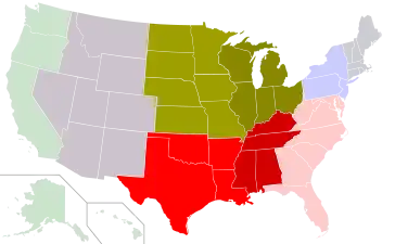 Census Bureau Divisions with "Central" in their name.
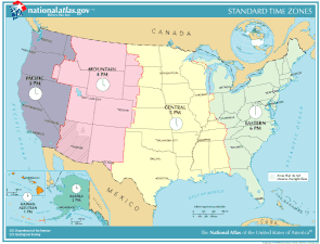 Map of U.S. time zones between April 2, 2006 and March 11, 2007. The current situation now has Pulaski County, Indiana in the Eastern Time Zone and no longer in the Central Time Zone.
Central regions defined by organizations
Different organizations define the central regions of the United States in a variety of ways:
- YPO Only 6 central states of the Midwest,[lower-alpha 1] plus KY
- CERI All of Midwest and South[lower-alpha 1] including MD, DE
- NOAA Midwest[lower-alpha 1] minus OH, plus KY, CO, WY
- HSUS Midwest[lower-alpha 1] minus ND, SD, KS, plus KY
- USGS West North Central States, South Central United States, 4 eastern Mountain states
- Adventure Camp Midwest plus South[lower-alpha 1] minus Atlantic states, AL, WV
- Geography of the Interior United States
- National League Central Division, members in PA, OH, WI, IL, MO; TX through 2012
- American League Central Division, members in OH, MI, IL, MN, MO
- National Basketball Association Central Division, members in OH, MI, IN, IL, WI, former members from NC, FL, GA, LA and Ontario (Canada)
- National Hockey League Central Division, members in CO, MN, TN, TX, IL, MO and Manitoba (Canada), former members in MI, AZ, OH and Ontario (Canada)
- Former National Football Conference Central Division, members in FL, MI, IL, WI, MN
- Former American Football Conference Central Division, members in MD, PA, FL, OH, TN, former member from TX
Geographic center of the United States
The geographic midpoint of the contiguous 48 states of the United States falls within the boundaries of the Central United States and is located about two miles northwest of Lebanon, Kansas. The spot is located at 39 degrees 50 minutes latitude and 98 degrees 35 minutes longitude.[3]
Notes
- See Census definition
References
- "U.S. Census website". Retrieved 2008-05-20.
- Iman Mallakpour & Gabriele Villarini (29 September 2014). "The changing nature of flooding across the central United States". Nature Climate Change. Nature. 5: 250–254. doi:10.1038/nclimate2516.
- "Geographic Center of the United States". www.kansastravel.org. Retrieved 2020-03-24.