Gass Peak
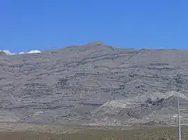
Gass Peak is the highest peak in the Las Vegas Range of Southern Nevada with a summit of 6,937 feet (2,114 m).[1] It is easily seen to the north of the Las Vegas Valley, bordering the city of North Las Vegas. The peak is located about 20 miles (32 km) north of Las Vegas and is within the Desert National Wildlife Refuge, administered by the U.S. Fish & Wildlife Service.[2]
| Gass Peak | |
|---|---|
 | |
| Highest point | |
| Elevation | 6,937 ft (2,114 m) |
| Prominence | 2,043 ft (623 m) |
| Coordinates | 36°24′02″N 115°10′50″W |
| Geography | |
| Location | Clark County, Nevada, U.S. |
| Parent range | Las Vegas Range |
| Topo map | USGS Gass Peak |
Gass Peak is accessible by the public and the most common access is via the Corn Creek Station off U.S. Route 95, northwest of Las Vegas. Roads are dirt roads and hiking trails are not maintained. A communications tower with solar panels has been built at the top of the peak.
Gass Peak is named for Octavius Decatur Gass (1828–1924), an early settler and prominent rancher of Las Vegas.[3]
References
- Ramelli, Alan. "Geologic map of the Gass Peak SW quadrangle, Clark County, Nevada". USGS. University of Nevada, Reno. Retrieved 27 March 2017.
- "Refuge Map - Desert - U.S. Fish and Wildlife Service". fws.gov. Retrieved 2016-01-29.
- Federal Writers' Project (1941). Origin of Place Names: Nevada (PDF). W.P.A. p. 15.
