Georgia State Route 172
State Route 172 (SR 172) is a 28.1-mile-long (45.2 km) state highway that runs southwest-to-northeast through portions of Madison, Elbert, and Hart counties in the northeastern part of the U.S. state of Georgia.
| ||||
|---|---|---|---|---|
 | ||||
| Route information | ||||
| Maintained by GDOT | ||||
| Length | 28.1 mi[1] (45.2 km) | |||
| Major junctions | ||||
| South end | ||||
| North end | ||||
| Location | ||||
| Counties | Madison, Elbert, Hart | |||
| Highway system | ||||
| ||||

Route description
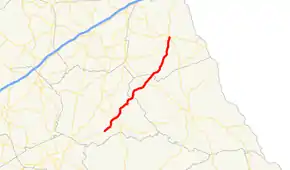
SR 172 begins at an intersection with SR 72, northeast of Colbert, in Madison County. It heads northeast to an intersection with SR 98, northwest of Comer. It continues to the northeast and crosses over the Broad River into Elbert County. In Bowman is an intersection with SR 17. Shortly afterward, SR 172 crosses into Hart County. It continues to the northeast until it meets its northern terminus, an intersection with US 29/SR 8/SR 77 in Hartwell.[1]
Major intersections
| County | Location | mi[1] | km | Destinations | Notes |
|---|---|---|---|---|---|
| Madison | | 0.0 | 0.0 | Southern terminus | |
| | 1.7 | 2.7 | South Fork Broad River | ||
| | 4.3 | 6.9 | |||
| Broad River | 10.7 | 17.2 | Madison–Elbert county line | ||
| Elbert | Bowman | 15.8 | 25.4 | ||
| Hart | Hartwell | 28.1 | 45.2 | Northern terminus | |
| 1.000 mi = 1.609 km; 1.000 km = 0.621 mi | |||||
See also
.svg.png.webp) Georgia (U.S. state) portal
Georgia (U.S. state) portal U.S. roads portal
References
- Google (June 23, 2013). "Route of SR 172" (Map). Google Maps. Google. Retrieved June 23, 2013.
This article is issued from Wikipedia. The text is licensed under Creative Commons - Attribution - Sharealike. Additional terms may apply for the media files.