Georgia State Route 515
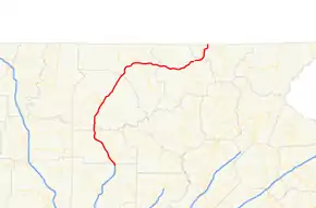
State Route 515 (SR 515) is a 76.2-mile-long (122.6 km) four-lane C-shaped state highway in the northern part of the U.S. state of Georgia. It begins just west of Nelson. It curves to the northeast to Lake Chatuge, where it heads north to the North Carolina state line. The highway was built to give motorists in the north Georgia mountains better access to Atlanta and its outlying suburbs, as opposed to the old SR 5 and U.S. Route 76 (US 76) highways, which this project replaced.
| ||||
|---|---|---|---|---|
| Zell Miller Mountain Parkway | ||||
 | ||||
| Route information | ||||
| Maintained by GDOT | ||||
| Length | 76.2 mi[1] (122.6 km) | |||
| Existed | 1989[2][3]–present | |||
| Major junctions | ||||
| South end | ||||
| ||||
| North end | ||||
| Highway system | ||||
| ||||

SR 515 is also known as the Zell Miller Mountain Parkway, in honor of Zell Miller, elected as Georgia governor and U.S. senator. It is one of the Georgia Department of Transportation's Governor's Road Improvement Program (GRIP) corridors. The highway is known for mountain views all along its route. SR 515 is part of the Appalachian Development Highway System's Corridor A, and is known as the "APD Highway." The highway was designated in 1989.
Route description
SR 515 begins just west of Nelson and just north of the Cherokee-Pickens County line, at the convergence of the northern terminus of Interstate 575, SR 5, the northern terminus of SR 5 Business, and the northern terminus of SR 372. It is concurrent with SR 5 from its southern terminus to Blue Ridge. It is also concurrent with US 76 from East Ellijay to a point between Young Harris and Hiawassee. It maintains a fairly strict south-north routing from its southern terminus to Blue Ridge and then becomes a due east-west route for the remainder of its length.[1]
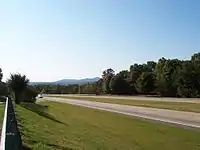
SR 515 is a significant route for the north Georgia mountains, funneling tourist traffic and serving as a growth corridor. SR 515 sees an Average Annual Daily Traffic (AADT) of more than 10,000 vehicles south of Blue Ridge, and at least 5,000 on the entirety of the route.[4]
The entire length of SR 515, including the concurrent sections, is part of the National Highway System, a system of routes determined to be the most important for the nation's economy, mobility and defense.[5]
History
The road that would eventually become numbered as SR 515 was established at least by 1919 along nearly the same alignment as it travels today. At the time, it was numbered as SR 5 from Nelson to Ellijay, SR 2 and possibly 5 from Ellijay to Blue Ridge, and SR 2 from Blue Ridge to the Young Harris area. The entire route was paved by this time.[6] In 1989, SR 515 was signed along its entire length.[2][3]
Major intersections
| County | Location | mi[1] | km | Destinations | Notes |
|---|---|---|---|---|---|
| Pickens | | 0.0 | 0.0 | Southern terminus; northern terminus of I-575; northern terminus of SR 5 Business/SR 372; southern end of SR 5 concurrency | |
| Jasper | 2.4 | 3.9 | Southern end of SR 53 concurrency | ||
| 7.0 | 11.3 | Northern end of SR 53 concurrency | |||
| | 12.3 | 19.8 | interchange | ||
| Gilmer | | 19.7 | 31.7 | ||
| East Ellijay | 24.9 | 40.1 | Southern end of US 76/SR 2 concurrency; eastern terminus of SR 282 | ||
| 25.5 | 41.0 | interchange | |||
| Fannin | Blue Ridge | 41.1 | 66.1 | north end of SR 5 overlap | |
| | 45.1 | 72.6 | |||
| Union | | 55.9 | 90.0 | ||
| Nottely River | 61.9 | 99.6 | Bridge | ||
| Blairsville | 63.0 | 101.4 | South end of US 19/US 129/SR 11 concurrency; former northern terminus of US 129 Truck/SR 11 Truck | ||
| 63.5 | 102.2 | Interchange | |||
| Chattahoochee-Oconee National Forest | North end of US 19/US 129/SR 11 concurrency; former north end of US 129 Truck/SR 11 Truck concurrency | ||||
| Towns | Young Harris | 71.6 | 115.2 | Southern terminus of SR 66 | |
| | 75.0 | 120.7 | Northern end of US 76/SR 2 concurrencies; southern end of SR 17 concurrency | ||
| | 76.0 | 122.3 | Eastern terminus of SR 339 | ||
| | 76.2 | 122.6 | North Carolina state line | ||
1.000 mi = 1.609 km; 1.000 km = 0.621 mi
| |||||
See also
.svg.png.webp) Georgia (U.S. state) portal
Georgia (U.S. state) portal U.S. roads portal
References
- Google (February 23, 2013). "Route of SR 515" (Map). Google Maps. Google. Retrieved February 23, 2013.
- Georgia Department of Transportation (1989). Official Highway and Transportation Map (PDF) (Map) (1989–1990 ed.). Scale not given. Atlanta: Georgia Department of Transportation. Retrieved February 23, 2013.
- Georgia Department of Transportation (1990). Official Highway and Transportation Map (PDF) (Map) (1990–1991 ed.). Scale not given. Atlanta: Georgia Department of Transportation. Retrieved February 23, 2013.
- "Archived copy" (PDF). Archived from the original (PDF) on 2007-09-25. Retrieved 2010-10-23.CS1 maint: archived copy as title (link)
- "National Highway System: Georgia" (PDF). United States Department of Transportation. May 8, 2009. Retrieved February 23, 2013.
- State Highway Department of Georgia (1920). System of State Aid Roads as Approved Representing 4800 Miles of State Aid Roads Outside the Limits of the Incorporated Towns (PDF) (Map). Scale not given. Atlanta: State Highway Department of Georgia. Retrieved February 23, 2013.
External links
![]() Media related to Georgia State Route 515 at Wikimedia Commons
Media related to Georgia State Route 515 at Wikimedia Commons