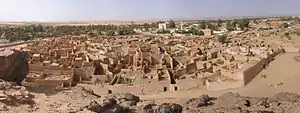
Ghat, Libya
Ghat (Arabic: غات) is the capital of the Ghat District in the Fezzan region of southwestern Libya, located just east of the Algerian border.
Ghat
غات | |
|---|---|
Town | |
 | |
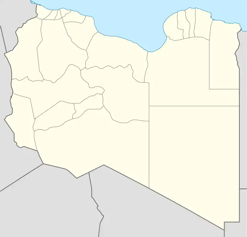 Ghat Location in Libya | |
| Coordinates: 24°57′52″N 10°10′41″E | |
| Country | |
| Region | Fezzan |
| District | Ghat |
| Elevation | 2,192 ft (668 m) |
| Population (2011)[2] | |
| • Total | 22,000 |
| Time zone | UTC+2 (EET) |
History
In historical times, Ghat was an important terminal point on a trans-Saharan trade route and a major administrative center in the Fezzan. It was a stronghold for the Kel Ajjer Tuareg federation whose territory covered most of south-western Libya - including Ubari, Sabha and Ghadames, plus south-eastern Algeria (Djanet and Illizi).
From the 5th century BC to the 5th century AD, the Fezzan was home to the Garamantian Empire, a city state which operated the Trans-Saharan trade routes between the Carthaginians—and later the Roman Empire—and the Sahelian states of West and Central Africa. During the 13th and 14th century, portions of the Fezzan were part of the Kanem Empire, while the Ottoman rulers of North Africa asserted their control over the region in the 17th century.
Beginning in 1911, Ghat and the Fezzan were occupied by Italy. Berber and Arab adherents to a militant Sufi religious order, the Sanusiya, resisted early Italian attempts at conquest, and Italy's control of the region was precarious until at least 1923, with the rise of the Italian Fascist regime. To defend their positions, the Italians built the Fortress of Ghat that dominates the city from the hill of Koukemen. This fort is still standing, and is a tourist attraction of the city.
During the Second World War, Ghat was occupied by France from 1943. On 21 November 1949, the United Nations General Assembly passed a resolution stating that Libya should become independent before 1 January 1952. Fezzan Province was then absorbed within the borders of the Kingdom of Libya.
Climate
Ghat has a hot desert climate (Köppen climate classification BWh) typical of the Fezzan, a Libyan region lying in the heart of the Sahara Desert. Averages high temperatures exceed 40 °C (104 °F) during summer for 3 months (June, July, August) and averages high temperatures remain above 20 °C (68 °F) during the coldest month of the year. Winter days are very warm, sunny and dry. Annual precipitation averages only 8 mm (0.32 in) making the location one of the driest places on Earth. The sky is always clear and bright throughout the year. Nevertheless in June 2019 there were heavy downpours which caused great damage to the town. Thousands of residents were stranded and few were reported dead or missing.[3]
| Climate data for Ghat | |||||||||||||
|---|---|---|---|---|---|---|---|---|---|---|---|---|---|
| Month | Jan | Feb | Mar | Apr | May | Jun | Jul | Aug | Sep | Oct | Nov | Dec | Year |
| Average high °C (°F) | 20.4 (68.7) |
25.1 (77.2) |
28.9 (84.0) |
34.4 (93.9) |
38.8 (101.8) |
41.2 (106.2) |
41.8 (107.2) |
40.9 (105.6) |
39.6 (103.3) |
34.7 (94.5) |
29.5 (85.1) |
23.5 (74.3) |
33.2 (91.8) |
| Daily mean °C (°F) | 13.6 (56.5) |
17.1 (62.8) |
21.4 (70.5) |
26.7 (80.1) |
31.0 (87.8) |
33.9 (93.0) |
33.9 (93.0) |
33.3 (91.9) |
31.6 (88.9) |
26.9 (80.4) |
21.7 (71.1) |
15.3 (59.5) |
25.3 (77.5) |
| Average low °C (°F) | 6.8 (44.2) |
9.1 (48.4) |
13.8 (56.8) |
18.9 (66.0) |
23.2 (73.8) |
26.6 (79.9) |
26.4 (79.5) |
25.9 (78.6) |
23.7 (74.7) |
19.2 (66.6) |
13.9 (57.0) |
8.9 (48.0) |
18.0 (64.5) |
| Average precipitation mm (inches) | 0 (0) |
1 (0.0) |
2 (0.1) |
0 (0) |
1 (0.0) |
1 (0.0) |
0 (0) |
0 (0) |
0 (0) |
1 (0.0) |
1 (0.0) |
1 (0.0) |
8 (0.1) |
| Source: Climatedata.org [4] | |||||||||||||
Present day
In the 2000s Ghat, as a garrison town, was the site of shootouts between Libyan security forces and al-Qaeda-linked fighters.[5] The Fezzan campaign and border proximity were the regional components that included Ghat in the Libyan Civil War. On September 25, 2011 fighting moved onto Ghat where the last remnants of pro-Gaddafi loyalists in Fezzan were claimed to be stationed.[6] NTC forces moved in, and took control of Ghat airport, located north of the city.[7] By the next day, the NTC had control of the city itself and Tinkarine border crossing with Algeria. As of 2015, the city is controlled by independent Tuareg forces.
Tourism
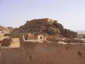
Ghat is an important tourist destination due to the existence of prehistoric rock paintings and engravings in the neighboring Tadrart Acacus and Tassili N'Ajjer mountains, in addition to the beauty of the surrounding desert landscapes. A major tourist attraction in the town itself is the Fortress of Ghat on Koukemen hill.
Ghat Airport is the local airport in Ghat. It is served by Ghadames Air Transport to Sabha.
See also
| Wikimedia Commons has media related to Ghat. |
- Berber
- Tuareg
- Green Sahara
- Fortress of Ghat
- List of cities in Libya
References
- "Wolfram-Alpha: Making the world's knowledge computable". www.wolframalpha.com.
- Der Spiegel, 2011 Aug 23
- "Thousands stranded in flood-ravaged Ghat, southwestern Libya". www.libyaobserver.ly.
- "Climat Ghat: Température moyenne Ghat, diagramme climatique pour Ghat - Climate-Data.org". fr.climate-data.org.
- Warren, Alex (24 August 2011). "Libya: what about the south?". The Guardian. Retrieved 11 September 2011.
- Spencer, Richard (25 September 2011). "Dumped in the desert ... Gaddafi's yellowcake stockpile". The Telegraph. Retrieved 9 October 2011.
- "فيديو: السيطرة على مطار غات الدولي". Libya TV. Archived from the original on 2011-10-07.
- Jami Bey, "Ghat and its Surroundings", The Geographical Journal Vol. 34, No. 2 Aug. 1909, pp. 171–173