Districts of Libya
There are twenty-two districts of Libya, known by the term shabiyah (Arabic singular شعبية šaʿbiyya, plural šaʿbiyyāt). In the 1990s these replaced the older baladiyat system.
 |
|---|
| This article is part of a series on the politics and government of Libya |
|
|
|
|
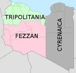
Historically the area of Libya was considered three provinces (or states), Tripolitania in the northwest, Cyrenaica in the east, and Fezzan in the southwest. It was the conquest by Italy in the Italo-Turkish War that united them in a single political unit. Under the Italians Libya was eventually divided into four provinces and one territory: Tripoli, Misrata, Benghazi, Derna, (in the north) and the Territory of the Libyan Sahara (in the south).[1] After the French and British occupied Libya in 1943, it was again split into three provinces: Tripolitania in the northwest, Cyrenaica in the east, and Fezzan-Ghadames in the southwest.[2]
Article 176 of the 1951 constitution of Libya stated "The Kingdom of Libya shall be divided into administrative units in conformity with the law to be promulgated in this connection. Local and regional councils may be formed in the Kingdom. The extent of these units shall be determined by law which shall likewise organize these Councils." in exact quote.
After independence (1951), Libya was divided into three governorates (muhafazat), matching the three provinces of before, but in 1963 it was divided into ten governorates. In 1983 a new system was introduced dividing the country into forty-six districts (baladiyat). In 1987 this was reduced to twenty-five districts.
On 2 August 1995, Libya reorganized into thirteen districts (shabiyat). In 1998 this was increased to 26 shabiyat districts. In 2001 it was increased to thirty-two districts plus three administrative regions. Finally in 2007 it was reduced to twenty-two districts.
For historical evolution see also: Subdivisions of Libya.
Libyan districts are further subdivided into Basic People's Congresses which act as townships or boroughs.
Districts (Shabiya)
Shabiyah (Arabic: شعبية šaʿbiyyah, plural: شعبيات šaʿbiyyāt) is a neologism exclusive to Libya under Gaddafi, in line with exclusive terms for republic (jamahiriya), ministry (amanah) and embassy (people's-bureau). The term basically means a district, that is, a top level administrative division. Etymologically, it is an adjective meaning "of or pertaining to the people, popular".
22 districts (2007)
In 2007 the current twenty-two districts (shabiya) replaced the older thirty-two district system.[3][4][5]
The current list is as following:
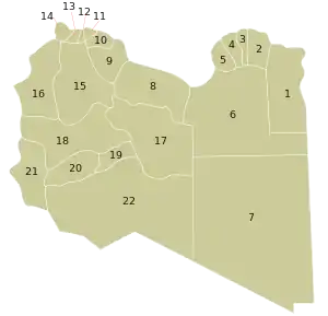
| Map no. | Name | English transliteration | Area (km2) | Population (2006)[6] |
|---|---|---|---|---|
| Cyrenaica | ||||
| 1 | البطنان | Al Butnan | 84,996 | 159,536 |
| 2 | درنة | Darnah | 31,511 | 163,351 |
| 3 | الجبل الاخضر | Al Jabal al Akhdar | 11,429 | 203,156 |
| 4 | المرج | Al Marj | 13,515 | 185,848 |
| 5 | بنغازي | Banghazi | 11,372 | 670,797 |
| 6 | الواحات | Al Wahat | 105,523 | 177,047 |
| 7 | الكفرة | Al Kufrah | 433,611 | 50,104 |
| Tripolitania | ||||
| 8 | سرت | Surt | 77,660 | 193,720 |
| 9 | مصراتة | Misratah | 29,172 | 550,938 |
| 10 | المرقب | Marqab | 6,796 | 432,202 |
| 11 | طرابلس | Tarabulus | 835 | 1,065,405 |
| 12 | الجفارة | Al Jafarah | 2,666 | 453,198 |
| 13 | الزاوية | Az Zawiyah | 2,753 | 290,993 |
| 14 | النقاط الخمس | An Nuqat al Khams | 6,089 | 287,662 |
| 15 | الجبل الغربي | Al Jabal al Gharbi | 76,717 | 304,159 |
| 16 | نالوت | Nalut | 67,191 | 93,224 |
| Fezzan | ||||
| 17 | الجفرة | Al Jufrah | 117,410 | 52,342 |
| 18 | وادي الشاطئ | Wadi ash Shati' | 97,160 | 78,532 |
| 19 | سبها | Sabha | 107,310 | 134,162 |
| 20 | وادي الحياة | Wadi al Hayat | 31,485 | 76,858 |
| 21 | غات | Ghat | 68,482 | 23,518 |
| 22 | مرزق | Murzuq | 356,308 | 78,621 |
32 districts (2001)
The 2001 reorganization of Libya into districts (shabiya)[7] resulted in thirty-two districts and three administrative regions (المنطقة الإدارية):
| شعبية | Sha'biyah | Population | Area (km2) | Number (on map) |
|---|---|---|---|---|
| إجدابيا | Ajdabiya | 165,839 | 91,620 | 1 |
| البطنان | Butnan | 144,527 | 83,860 | 2 |
| الحزام الاخضر | Hizam al Akhdar | 108,860 | 12,800 | 3 |
| الجبل الاخضر | Jabal al Akhdar | 194,185 | 7,800 | 4 |
| الجفارة | Jafara | 289,340 | 1,940 | 5 |
| الجفرة | Jufra | 45,117 | 117,410 | 6 |
| الكفرة | Kufra | 51,433 | 483,510 | 7 |
| المرج | Marj | 116,318 | 10,000 | 8 |
| المرقب | Murqub | 328,292 | 3,000 | 9 |
| النقاط الخمس | Nuqat al Khams | 208,954 | 5,250 | 10 |
| القبة | Quba | 93,895 | 14,722 | 11 |
| الواحات | Al Wahat | 29,257 | 108,670 | 12 |
| الزاوية | Zawiya | 197,177 | 1,520 | 13 |
| بنغازي | Benghazi | 636,992 | 800 | 14 |
| بنى وليد | Bani Walid | 77,424 | 19,710 | 15 |
| درنة | Derna | 81,174 | 4,908 | 16 |
| غات | Ghat | 22,770 | 72,700 | 17 |
| غدامس | Ghadames | 19,000 | 51,750 | 18 |
| غريان | Gharyan | 161,408 | 4,660 | 19 |
| مرزق | Murzuq | 68,718 | 349,790 | 20 |
| مزدة | Mizda | 41,476 | 72,180 | 21 |
| مصراتة | Misrata | 360,521 | 2,770 | 22 |
| نالوت | Nalut | 86,801 | 13,300 | 23 |
| تاجوراء والنواحي الأربع | Tajura wa Arba‘ | 267,031 | 1,430 | 24 |
| ترهونة و مسلاته | Tarhuna wa Msalata | 296,092 | 5,840 | 25 |
| طرابلس | Tripoli | 882,926 | 400 | 26 |
| سبها | Sabha | 126,610 | 15,330 | 27 |
| سرت | Sirte | 156,389 | 77,660 | 28 |
| صبراته و صرمان | Sabratha wa Sorman | 152,521 | 1,370 | 29 |
| وادي الحياة | Wadi al Hayaa | 72,587 | 31,890 | 30 |
| وادي الشاطئ | Wadi al Shatii | 77,203 | 97,160 | 31 |
| يفرن | Yafran | 117,647 | 9,310 | 32 |
The three administrative regions are missing from the above map, Qatrun,[8] Marada,[9] and Jaghbub[10]
26 districts (1998)
In 1998 Libya was reorganized into twenty-six districts which were: Butnan, Jafara, Jufra, Kufra, Marj, Murqub, Quba, Al Wahat, Bani Walid, Benghazi, Derna, Gharyan, Jabal al Akhdar, Murzuq, Misrata, Nalut, Nuqat al Khams, Sabha, Sabrata/Sorman, Sirte, Tarhuna/Msalata, Tripoli, Wadi al Hayaa, Wadi al Shatii, Yafran, and Zawiya[11]
13 districts (1995)
On 2 August 1995 Libya dropped the baladiyat system and reorganized into thirteen districts (shabiyat). Among them were Butnan (formerly Tobruk), Jabal al Akhdar, Jabal al Gharbi, Zawiya, Benghazi, and Tripoli. However, there is not agreement about the other seven names.[5]
Former baladiya
Baladiyah (singular) or baladiyat (plural), are Arabic words used in many Arab countries to denote administrative divisions of the country. In Libya, the baladiyat system of districts was introduced in 1983 to replace the governorate system. Originally there were forty-six baladiyat districts,[5] but in 1988 that number was reduced to twenty-five baladiyat. The table hereunder lists the old twenty-five baladiyat in alphabetical order with a link to each one and numbered to be located on the map. Note that each district linked may be both a baladiyah and a shabiyah. The many changes may not always be reflected in the article.
|
|
 Map showing subdivision of former governorates into the 25 baladiya
|
Evolution
| شعبية / بلدية | Name | 2007 (22) | 2001 (32) | Name in 1998 (26) | 1995 (13) | 1988 (25) | Capital |
|---|---|---|---|---|---|---|---|
| إجدابيا | Ajdabiya District | x | x | Ajdabiya | |||
| البطنان | Butnan District (Tobruk in 1995, from 1988 Tobruk District) | x | x | Batan | x | Tobruk | Tobruk |
| الحزام الاخضر | Hizam al Akhdar District | x | Aybar | ||||
| الجبل الاخضر | Jabal al Akhdar | x | x | Jabal al Akhdar | x | x | Bayda |
| الجبل الغربي | Jabal al Gharbi District | x | x | Gharyan | |||
| الجغبوب | Jaghbub Administrative Region | AR | Administrative Region | ||||
| الجفارة | Jafara (from 1988 'Aziziya District) | x | x | Jafara | 'Aziziya | 'Aziziya | |
| الجفرة | Jufra District | x | x | Jufra | 4 | x | Hun |
| الكفرة | Kufra District | x | x | Kufra | 5 | x | Al Jawf |
| المرج | Marj District (1983–1988 Fati District) | x | x | Marj | Fati | Marj, Barca in antiquity | |
| المرقب | Murqub District (Morqib) (from 1995 & 1988 Khoms District) | x | x | Murqub | 5 | Khoms | Khoms |
| القطرون | Qatrun Administrative Region | AR | Administrative Region | ||||
| القبة | Quba District | x | Quba | Quba, or Giovanni Berta | |||
| الواحات | Al Wahat District (Waha in 1995) | x | x | Wahad | 4 | Ajdabiya (cf. Ajdabiya District) | |
| الوسطى | Wusta | 4 | |||||
| النقاط الخمس | Nuqat al Khams (Nikat al Khums in 1995) | x | x | Nikat al Khams | 5 | x | Zuwara |
| أوباري | Awbari District | 5a | x | Ubari | |||
| الزاوية | Zawiya District | x | x | Zawiya | x | x | Zawiya |
| بني وليد | Bani Walid District (from 1988 Sawfajjin District) | x | Bani Walid | Bani Walid | |||
| بنغازي | Benghazi | x | x | Benghazi | x | x | Benghazi |
| درنة | Derna District | x | x | Derna | x | Derna | |
| فزان | Fezzan (or Fazzan) | 4 | Sabha | ||||
| غدامس | Ghadames District | x | x | Ghadames | |||
| غريان | Gharyan District | x | Gharyan | x | Gharyan | ||
| غات | Ghat District (from 1988 Ubari) | x | x | Ghat | |||
| مرادة | Marada Administrative Region | AR | Administrative Region | ||||
| مصراتة | Misrata District (includes 1988 Bani Walid District and Zlitan District) | x | x | Misrata | 4 | x | Misrata |
| مزدة | Mizda District | x | Mizda | ||||
| مرزق | Murzuq District (Marzug in 1995) | x | x | Murzaq | 5 | x | Murzuk |
| النقازة | Naggaza | 4 | |||||
| نالوت | Nalut District | x | x | Nalout | Nalut | ||
| سبها | Sabha District | x | x | Sabha | 5 | x | Sabha |
| صبراته و صرمان | Sabratha wa Sorman District | x | Sabratha & Sorman | ||||
| سوف الجين | Sawfajjin District | 4 | x | Bani Walid | |||
| سرت | Sirte District (Khalij Sirte in 1995) | x | x | Sirte | 5 | x | Sirte |
| تاجوراء والنواحي الأربع | Tajura wa Arba‘ District | x | Tajura | ||||
| طرابلس | Tripoli District | x | x | Tripoli | x | x | Tripoli |
| ترهونة و مسلاته | Tarhuna wa Msalata District (from 1988 Tarhuna District) | x | Tarhuna & Msalata | Tarhuna | Tarhuna | ||
| وادي الحياة | Wadi al Hayaa District (1995 Wadi al Hait?, from 1988 Ubari) | x | x | Wadi al Hait? | 5b | ||
| وادي الشاطئ | Wadi al Shatii District (Shati' in 1988) | x | x | Wadi al Shaati | Shati' | Adiri[12] or Brak[13] | |
| يفرن | Yafran District (Yifren) | x | Yefrin | x | Yafran | ||
| زليتن | Zlitan District | x | Zliten |
For 1995 data, [4] and [5] are the two different sources mentioned in the bibliography:[5] "The Europa World Year Book 2001" and "Ershiyi (21) Shiji Shijie Diming Lu", Beijing, 2001.
For 1988, name is provided if different from nowadays. As said above, AR stands for the three "Administrative Region" of 2001.
Fazzan wasn't strictly a district, but a historical muhafazah or wilayah along with Tripolitania (capital Tripoli) and Cyrenaica (capital Cyrene -near nowadays Shahhat- with Diocletian, moved to Ptolemais after the earthquake of 365, and to Barce -nowadays Barca- with Omer Bin Khattab in 643).
Notes
- Pan, Chia-Lin (1949) "The Population of Libya" Population Studies, 3(1): pp. 100–125, p. 104
- "Map of Libya 1943–1951" Zentrale für Unterrichtsmedien
- شعبيات الجماهيرية العظمى – Sha'biyat of Great Jamahiriya Archived December 20, 2008, at the Wayback Machine, accessed 10 May 2009, in Arabic
-
- "Libya population statistics" (in English and Arabic). Geohive. Archived from the original on 15 October 2009. Retrieved 30 October 2009.
- "Districts of Libya". Statoids.com. Retrieved 7 November 2010.
- Libyan General Information Authority Archived 2011-02-24 at the Wayback Machine accessed 22 July 2009
- "الشعبيات بالجماهيرية" ("Districts of Libya") Website of the General People's Committee of Libya, from WebArchive dated 30 August 2006
- "Districts of Libya:Alqtron Tjrhi" Website of the General People's Committee of Libya, in Arabic, from Web Archive dated 30 August 2006
- "Districts of Libya:Mradq" Website of the General People's Committee of Libya, in Arabic, from Web Archive dated 30 August 2006
- "Districts of Libya:Aljgbob" Website of the General People's Committee of Libya, in Arabic, from Web Archive dated 30 August 2006
- "Libya" 2006 Statesman's Yearbook
- "Districts of Libya". statoids.com. Retrieved 27 October 2009. and German wikipedia
- Spanish, Italian, Polish and Portuguese wikipedias
External links
| Look up شعبية in Wiktionary, the free dictionary. |
- Historical population data by district from Universiteitsbibliotheek Utrecht (Library, University of Utrecht), retrieved by WebArchive.
- Administrative Map of Libya – Nations Online Project
Historical regions of Libya | |||
|---|---|---|---|