Ghotki District
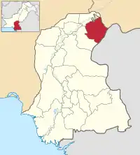
Ghotki District (Sindhi: ضِلعو گھوٽڪي; Urdu: ضلع گھوٹکی) is a district of the province of Sindh, Pakistan, with headquarters the city of Mirpur Mathelo. Prior to its establishment as a district in 1983, it formed part of Sukkur District.[2] According to the 1998 census, the district had a population of 970,550. Of these residents, 158,500 (16.33%) lived in urban areas, and 812,050 (83.67%) lived in rural areas.[3]
Ghotki District
ضِلعو گھوٽڪي | |
|---|---|
 Location of Ghotki in Sindh province | |
| Coordinates: 27°49′N 69°39′E | |
| Country | |
| Province | |
| District Government | Mirpur Mathelo |
| District | 1983 |
| District Administration | Mirpur Mathelo |
| Area | |
| • Total | 6,083 km2 (2,349 sq mi) |
| Population (2017)[1] | |
| • Total | 1,646,318 |
| • Density | 270/km2 (700/sq mi) |
| Time zone | UTC+5 (PST) |
| Website | www |
Administration
The Ghotki district is administratively subdivided into the following Tehsils:
Location
The Ghotki District is a border district between the northern Sindh province of Pakistan and Punjab, Pakistan.
Industry and economics
Ghotki is an industrial area in the Sindh province. Local companies based in Ghotki include OGDCL, Engro Fertilizers, Fauji fo Fertilizers (formerly Pak Saudi Fertilizer), TNB Liberty Power Plant, EngroPowergen PowerPlant, and Dosan Power Plant. Ghotki also has three gas fields: the Mari Gas Field, Qadirpur Gas Field, and Rehmat Gas Field.
Cotton is one of the district's major crops, with forty cotton-ginning factories in Ghotki. Another valuable crop is sugar cane. Four sugar mills are located in the Ghotki District: JDW Sugar Mills-3, SGM Sugar Mills, Daherki Sugar Mills, and Reti Sugar Mills.
The region is also famous for its mangoes, vegetables, and abundance of date trees. The important products of Ghotki includes cotton, wheat, sugar, rice, milk, pottery etc. Fishing and tourism is also play an important role in economy.
Sugar Cane
Ghotki District has recently embraced sugar cane. The total acreage of cultivable land is 286,090 ha in 2019-20. The area under cultivation of sugar cane increased to 58,774 ha in 2019-20 from 6,511 ha in 2011-12. Five functional sugar mills are located in the district.[4]
Geography
Ghotki District is streched in 6975 Sqkm (1,555,528 acres). 25,000 acres area of the district consisting of desert land, 402,578 acres (25.88%) is flooded (Katcha) area and remaining area lying between desert and flooded areas of district is cultivated. Desert area having wind-blown hills as Achro Thar (White Desert). Flooded area (Kacha) is stretched on 87 Kms along Indus River from north - east to south - west of the district where forests exist in this area.[5]
Demography
According to the 1998 census results, the major first languages spoken in the district were Sindhi (92%), Urdu (3.1%) and Punjabi (2.9%).[6]
Religion
Per the 1998 census of Pakistan,[7] the most common religions in the Ghotki District are:
- Islam 93.06%
- Hinduism 6.68%
- Christianity 0.14%
- Others: 0.04%
The historic Shadani Darbar is located in here.[8]
See also
References
- "DISTRICT WISE CENSUS RESULTS CENSUS 2017" (PDF). www.pbscensus.gov.pk. Archived from the original (PDF) on 2017-08-29. Retrieved 2017-09-03.
- PCO 1998, p. 10.
- "Archived copy". Archived from the original on 2014-11-29. Retrieved 2014-11-23.CS1 maint: archived copy as title (link)
- Khan, Mohammad Hussain (2020-11-30). "Ghotki's story of sugar and cotton". DAWN.COM. Retrieved 2020-12-29.
- https://www.suhnisindh786.com/2020/10/district-ghotki-historical-city.html
- PCO 1998, p. 26.
- http://www.pbs.gov.pk/sites/default/files/other/pocket_book2006/2.pdf
- "Hindu pilgrims attend central ceremony of Shadani Darbar". Pakistan Today. 6 December 2018. Retrieved 23 December 2020.
Bibliography
- 1998 District census report of Ghotki. Census publication. 88. Islamabad: Population Census Organization, Statistics Division, Government of Pakistan. 2000.