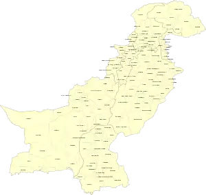
Districts of Pakistan
The Districts of Pakistan (Urdu: اِضلاعِ پاكِستان); are the third-order administrative divisions of Pakistan, below provinces and divisions, but forming the first tier of local government. In total, there are 130 districts in Pakistan, including the Islamabad Capital Territory, 10 districts in Pakistan's dependent territory of Azad Kashmir, and 14 districts in Pakistan's dependent territory of Gilgit Baltistan.[2][3] Districts are divided into tehsils, which are further divided into union councils.
 |
|---|
| This article is part of a series on the politics and government of Pakistan |
|
|
| Districts of Pakistan, Azad Kashmir, and Gilgit-Baltistan | |
|---|---|
 | |
| Category | Districts (third-order administrative divisions) |
| Number | 130 (as of 2017) |
| Populations | Greatest: Lahore, Punjab—11,126,285 (2017 census)[1] Least: Awaran, Balochistan—121,660 (2017 census)[1] |
| Areas | Largest: Chagai, Balochistan—44,748 km2 (17,277 sq mi) Smallest: Torghar, Khyber Pakhtunkhwa—497 km2 (192 sq mi) |
| Government | District, Tehsil, Union Council |
History
In 1947, when Pakistan gained independence, there were 124 districts. In 1969, two new districts (Tangail and Patuakhali) in East Pakistan were formed, bringing the total to 126. After the independence of Bangladesh, Pakistan lost 20 of its districts, resulting in a total of 106 districts. In 2001, the number was reduced to 102 by the merger of the five districts of Karachi Central, Karachi East, Karachi South, Karachi West, and Malir to form the new Karachi District. The number of districts rose to 106 again in December 2004, when four new districts were created in the province of Sindh, one of which (Umerkot) had existed from 2000 and three (Kashmore, Qambar and Jamshoro) which were newly created.[4][lower-alpha 1] The new districts were carved out of Mirpur Khas, Jacobabad, Larkana and Dadu Districts respectively. In May 2005, the Punjab provincial government created a new district by raising the status of Nankana Sahib from a tehsil of Sheikhupura District to a district in its own right.[5][lower-alpha 2] On July 11, 2011, the Sindh Government restored the districts of Karachi Central, Karachi East, Karachi South, Karachi West, and Malir, and later, in 2013, the district of Korangi was created from part of the Karachi East District. In Azad Jammu and Kashmir, a second tier of government consisting of three administrative divisions was created. In Gilgit–Baltistan, a second tier of government consisting of three divisions was created. In 2018, the Federally Administered Tribal Areas (FATA) were merged with the Khyber Pakhtunkhwa Province, and the FATA agencies were converted into districts.
The Chagai District is the largest district of Pakistan by area, whereas the Lahore District is the largest by population, with a total population of 11,126,285 at the 2017 census. The Quetta District is the largest district of Balochistan by population, with a total population of 2,275,699 at the 2017 census. The Bahawalpur District is the largest district of Punjab by area. In Khyber Pakhtunkhwa, the Chitral District is the largest by area, and the Peshawar District is the largest by population, with a population of 4,269,079 at the 2017 census. Sindh's largest district by area is the Tharparkar District,[6]and its largest by population is the Karachi West District, with a population of 3,914,757 at the 2017 census. The combined population of the six districts of the Karachi Division is over 16 million at the 2017 census, giving an average population of those six districts at more than 2.675 million each. The Neelum District and the Kotli District are the largest districts of Azad Kashmir by area and population, respectively. For Gilgit-Baltistan, the Gilgit District is the largest by both area and population.
Pakistan
| Sr. No. | Province / Capital territory | Districts | Area (km²) |
Population (2017)[7] |
Density (people/km²) |
Country of Comparable Size |
|---|---|---|---|---|---|---|
| 1 | Balochistan | 34[8] | 347,190 | 12,344,408 | 35.55 | |
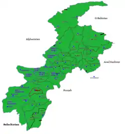
| 2 | Khyber Pakhtunkhwa | 34[9] | 101,741 | 35,525,047 | 349.17 | |
| 3 | Punjab | 36[10] | 205,345 | 110,012,442 | 535.74 | |
| 4 | Sindh | 29[11] | 140,914 | 47,886,051 | 339.82 | |
| 5 | Islamabad Capital Territory | 1 | 906 | 2,006,572 | 2,214.76 | |
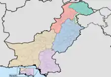
Azad Jammu and Kashmir
| Sr. No. | Dependent territory | Districts | Area (km²) |
Population (2017)[12] |
Density (people/km²) |
Country of Comparable Size |
|---|---|---|---|---|---|---|
| 6 | Azad Jammu and Kashmir | 10 | 13,297 | 4,045,366 | 304.23 |
Gilgit-Baltistan
| Sr. No. | Dependent territory | Districts | Area (km²) |
Population (2017)[13] |
Density (people/km²) |
Country of Comparable Size |
|---|---|---|---|---|---|---|
| 7 | Gilgit-Baltistan | 14 | 72,971 | 3,500,000 | 47.96 |
Districts of Pakistan
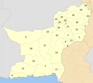
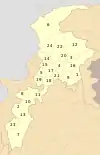
Balochistan
| Sr. No. | District | Headquarters | Area (km²) |
Population (2017)[14] |
Density (people/km²) |
Division |
|---|---|---|---|---|---|---|
| 1 | Awaran | Awaran | 29,510[15] | 122,011 | 4 | Kalat |
| 2 | Barkhan | Barkhan | 3,514 | 171,556 | 48.8 | Zhob |
| 4 | Chagai | Chagai | 44,748[16] | 226,008 | 5 | Quetta |
| 3 | Dera Bugti | Dera Bugti | 10,160 | 312,603 | 31 | Sibi |
| 5 | Gwadar | Gwadar | 12,637 | 263,514 | 21 | Makran |
| 6 | Harnai[17] | Harnai | 4,096 | 97,017 | 24 | Sibi |
| 7 | Jafarabad | Dera Allahyar | 2,445 | 513,813 | 210 | Nasirabad |
| 8 | Jhal Magsi | Jhal Magsi | 3,615 | 149,225 | 41 | Nasirabad |
| 9 | Kachhi | Dhadar | 7,499 | 237,030 | 32 | Nasirabad |
| 10 | Kalat | Kalat | 6,622 | 412,232 | 62 | Kalat |
| 11 | Kech | Turbat | 22,539 | 909,116 | 40 | Makran |
| 12 | Kharan | Kharan | 8,958 | 156,152 | 17 | Kalat |
| 13 | Khuzdar | Khuzdar | 35,380 | 802,207 | 23 | Kalat |
| 14 | Killa Abdullah | Chaman | 3,293 | 757,578 | 230 | Quetta |
| 15 | Killa Saifullah | Killa Saifullah | 6,831 | 342,814 | 50 | Zhob |
| 16 | Kohlu | Kohlu | 7,610 | 214,350 | 28 | Sibi |
| 17 | Lasbela | Uthal | 15,153 | 574,292 | 38 | Kalat |
| 18 | Lehri | Bakhtiarabad | 9,830 | 118,046 | 12 | Nasirabad |
| 19 | Loralai | Loralai | 9,830 | 397,400 | 40 | Zhob |
| 20 | Mastung | Mastung | 5,896 | 266,461 | 45 | Kalat |
| 21 | Musakhel | Musa Khel Bazar | 5,728 | 167,017 | 29 | Zhob |
| 22 | Nasirabad | Dera Murad Jamali | 3,387 | 490,538 | 145 | Nasirabad |
| 23 | Nushki[18] | Nushki | 5,797 | 178,796 | 31 | Quetta |
| 24 | Panjgur | Panjgur | 16,891 | 316,385 | 19 | Makran |
| 25 | Pishin | Pishin | 7,819 | 736,481 | 94 | Quetta |
| 26 | Quetta | Quetta | 2,653 | 2,275,699 | 858 | Quetta |
| 27 | Sherani | Sherani | 2,800 | 153,116 | 55 | Zhob |
| 28 | Sibi | Sibi | 7,796 | 135,572 | 17 | Sibi |
| 29 | Sohbatpur | Sohbatpur | 1,412 | 200,538 | 142 | Nasirabad |
| 30 | Washuk | Washuk | 29,510 | 176,206 | 6 | Kalat |
| 31 | Zhob | Zhob | 20,297 | 310,544 | 15 | Zhob |
| 32 | Ziarat | Ziarat | 1,489 | 160,422 | 108 | Kalat |
| 33 | Duki | Zhob | 153,000 | Zhob |
Khyber Pakhtunkhwa
| Sr. No. | District | Headquarters | Area (km²) | Population (2017)[1] | Density (people/km²) | Division |
|---|---|---|---|---|---|---|
| 1 | Abbottabad | Abbottabad | 1,967 | 1,332,912 | 785 | Hazara |
| 2 | Bajaur | Khar | 1,290 | 1,093,684 | 848 | Malakand |
| 3 | Bannu | Bannu | 1,227 | 1,167,892 | 952 | Bannu |
| 4 | Battagram | Battagram | 1,301 | 476,612 | 366 | Hazara |
| 5 | Buner | Daggar | 1,865 | 897,319 | 481 | Malakand |
| 6 | Charsadda | Charsadda | 996 | 1,616,198 | 1,623 | Peshawar |
| 7 | Chitral | Chitral | 14,850 | 447,362 | 30 | Malakand |
| 8 | Dera Ismail Khan | Dera Ismail Khan | 7,326 | 1,627,132 | 222 | Dera Ismail Khan |
| 9 | Hangu | Hangu | 1,097 | 518,798 | 473 | Kohat |
| 10 | Haripur | Haripur | 1,725 | 1,003,031 | 581 | Hazara |
| 11 | Karak | Karak | 3,372 | 706,299 | 209 | Kohat |
| 12 | Khyber | Landi Kotal | 2,576 | 986,973 | 383 | Peshawar |
| 13 | Kohat | Kohat | 2,545 | 993,874 | 390 | Kohat |
| 14 | Kurram | Parachinar | 3,380 | 619,553 | 201 | Kohat |
| 15 | Lakki Marwat | Lakki Marwat | 3,164 | 876,182 | 277 | Bannu |
| 16 | Lower Dir | Timergara | 1,582 | 1,435,917 | 908 | Malakand |
| 17 | Lower Kohistan | Pattan | 7,492 | 784,711* | 105 | Hazara |
| 18 | Malakand | Batkhela | 952 | 720,295 | 757 | Malakand |
| 19 | Mansehra | Mansehra | 4,579 | 1,556,460 | 340 | Hazara |
| 20 | Mardan | Mardan | 1,632 | 2,373,061 | 1,454 | Mardan |
| 21 | Mohmand | Ghalanai | 2,296 | 466,984 | 203 | Peshawar |
| 22 | North Waziristan | Miranshah | 4,707 | 543,254 | 115 | Bannu |
| 23 | Nowshera | Nowshera | 1,748 | 1,518,540 | 869 | Peshawar |
| 24 | Orakzai | Kalaya | 1,538 | 254,356 | 165 | Kohat |
| 25 | Peshawar | Peshawar | 1,257 | 4,269,079 | 3,396 | Peshawar |
| 26 | Shangla | Alpuri | 1,586 | 757,810 | 478 | Malakand |
| 27 | South Waziristan | Wana | 6,620 | 679,185 | 103 | Dera Ismail Khan |
| 28 | Swabi | Swabi | 1,543 | 1,624,616 | 1,053 | Mardan |
| 29 | Swat | Saidu Sharif | 5,337 | 2,309,570 | 433 | Malakand |
| 30 | Tank | Tank | 1,679 | 391,885 | 233 | Dera Ismail Khan |
| 31 | Torghar | Judba | 497 | 171,395 | 345 | Hazara |
| 32 | Upper Dir | Dir | 3,699 | 946,421 | 256 | Malakand |
| 33 | Upper Kohistan | Dasu | 7,492 | 784,711* | 105 | Hazara |
Note: Recently merged 7 agencies and Frontier Regions of FATA in Khyber Pakhtunkhwa included in the list. Population and area of Frontier Regions is merged in respective districts.
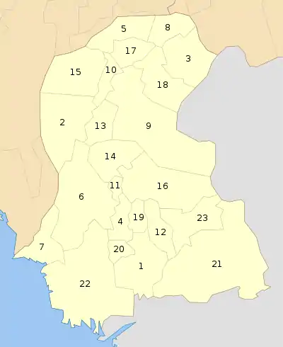
Punjab
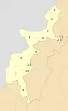
_Districts.svg.png.webp)
| Sr. No. | District | Headquarters | Area (km²) |
Population (2017) |
Density (people per km²) |
Division |
|---|---|---|---|---|---|---|
| 1 | Attock | Attock | 6,858 | 1,883,556 | 275 | Rawalpindi |
| 2 | Bahawalnagar | Bahawalnagar | 8,878 | 2,981,919 | 336 | Bahawalpur |
| 3 | Bahawalpur | Bahawalpur | 24,830 | 3,668,106 | 148 | Bahawalpur |
| 4 | Bhakkar | Bhakkar | 8,153 | 1,650,518 | 202 | Sargodha |
| 5 | Chakwal | Chakwal | 6,524 | 1,495,982 | 229 | Rawalpindi |
| 6 | Chiniot | Chiniot | 2,643 | 1,369,740 | 518 | Faisalabad |
| 7 | Dera Ghazi Khan | Dera Ghazi Khan | 11,922 | 2,872,201 | 241 | Dera Ghazi Khan |
| 8 | Faisalabad | Faisalabad | 5,856 | 7,873,910 | 1,345 | Faisalabad |
| 9 | Gujranwala | Gujranwala | 3,622 | 5,014,196 | 1,384 | Gujranwala |
| 10 | Gujrat | Gujrat | 3,192 | 2,756,110 | 863 | Gujranwala |
| 11 | Hafizabad | Hafizabad | 2,367 | 1,156,957 | 489 | Gujranwala |
| 12 | Jhang | Jhang | 8,809 | 2,743,416 | 311 | Faisalabad |
| 13 | Jhelum | Jhelum | 3,587 | 1,222,650 | 341 | Rawalpindi |
| 14 | Kasur | Kasur | 4,796 | 3,454,996 | 720 | Lahore |
| 15 | Khanewal | Khanewal | 4,349 | 2,921,986 | 6900 | Multan |
| 16 | Khushab | Jauharabad | 6,511 | 1,281,299 | 197 | Sargodha |
| 17 | Lahore | Lahore | 1,772 | 11,126,285 | 6,279 | Lahore |
| 18 | Layyah | Layyah | 6,291 | 1,824,230 | 290 | Dera Ghazi Khan |
| 19 | Lodhran | Lodhran | 2,778 | 1,700,620 | 612 | Multan |
| 20 | Mandi Bahauddin | Mandi Bahauddin | 2,673 | 1,593,292 | 596 | Gujranwala |
| 21 | Mianwali | Mianwali | 5,840 | 1,546,094 | 265 | Sargodha |
| 22 | Multan | Multan | 3,720 | 4,745,109 | 1,275 | Multan |
| 23 | Muzaffargarh | Muzaffargarh | 8,249 | 4,322,009 | 524 | Dera Ghazi Khan |
| 24 | Narowal | Narowal | 2,337 | 1,709,757 | 732 | Gujranwala |
| 25 | Nankana Sahib[5] | Nankana Sahib | 2,960 | 1,356,374 | 458 | Lahore |
| 26 | Okara | Okara | 4,377 | 3,039,139 | 694 | Sahiwal |
| 27 | Pakpattan | Pakpattan | 2,724 | 1,823,687 | 669 | Sahiwal |
| 28 | Rahim Yar Khan | Rahim Yar Khan | 11,880 | 4,814,006 | 405 | Bahawalpur |
| 29 | Rajanpur | Rajanpur | 12,319 | 1,995,958 | 162 | Dera Ghazi Khan |
| 30 | Rawalpindi | Rawalpindi | 5,286 | 5,405,633 | 1,322 | Rawalpindi |
| 31 | Sahiwal | Sahiwal | 3,201 | 2,517,560 | 786 | Sahiwal |
| 32 | Sargodha | Sargodha | 5,854 | 3,703,588 | 633 | Sargodha |
| 33 | Sheikhupura | Sheikhupura | 3,030 | 3,460,426 | 1,142 | Lahore |
| 34 | Sialkot | Sialkot | 3,016 | 3,893,672 | 1,291 | Gujranwala |
| 35 | Toba Tek Singh | Toba Tek Singh | 3,252 | 2,190,015 | 673 | Faisalabad |
| 36 | Vehari | Vehari | 4,364 | 2,897,446 | 664 | Multan |
Sindh
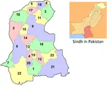
| Sr. No. | District | Headquarters | Area (km²) |
Population (2017) |
Density (people/km²) |
Division |
|---|---|---|---|---|---|---|
| 1 | Badin | Badin | 6,726 | 1,804,516 | 268 | Banbhore |
| 2 | Dadu | Dadu | 7,866 | 1,550,266 | 197 | Hyderabad |
| 3 | Ghotki | Mirpur Mathelo | 6,083 | 1,646,318 | 270 | Sukkur |
| 4 | Hyderabad | Hyderabad | 5,519 | 2,199,463 | 398 | Hyderabad |
| 5 | Jacobabad | Jacobabad | 5,278 | 1,006,297 | 191 | Larkana |
| 6 | Jamshoro | Jamshoro | 11,250 | 993,142 | 88 | Hyderabad |
| 7 | Karachi Central | Karachi | 69 | 2,971,626 | 43,067 | Karachi |
| 8 | Karachi East | Karachi | 165 | 2,907,467 | 17,610 | Karachi |
| 9 | Karachi South | Karachi | 122 | 1,791,751 | 14,686 | Karachi |
| 10 | Karachi West | Karachi | 929 | 3,914,757 | 4,214 | Karachi |
| 11 | Kashmore | Kandhkot | 2,592 | 1,089,169 | 420 | Larkana |
| 12 | Khairpur | Khairpur | 15,910 | 2,404,334 | 151 | Sukkur |
| 13 | Korangi | Korangi | 95 | 2,457,019 | 25,918 | Karachi |
| 14 | Larkana | Larkana | 1,906 | 1,524,391 | 205 | Larkana |
| 15 | Malir | Malir | 2,268 | 2,008,901 | 886 | Karachi |
| 16 | Matiari | Matiari | 1,417 | 769,349 | 543 | Hyderabad |
| 17 | Mirpur Khas | Mirpur Khas | 2,925 | 1,505,876 | 515 | Mirpur Khas |
| 18 | Naushahro Feroze | Naushahro Feroze | 2,945 | 1,612,373 | 548 | Shaheed Benazir Abad |
| 19 | Qambar Shahdadkot | Qambar | 5,599 | 1,341,042 | 239 | Larkana |
| 20 | Sanghar | Sanghar | 10,720 | 2,057,057 | 192 | Mirpur Khas |
| 21 | Shaheed Benazir Abad | Nawabshah | 4,502 | 1,612,847 | 358 | Shaheed Benazir Abad |
| 22 | Shikarpur | Shikarpur | 2,512 | 1,231,481 | 490 | Larkana |
| 23 | Sujawal | Sujawal | 8,699[19] | 781,967 | 106 | Banbhore |
| 24 | Sukkur | Sukkur | 2,512 | 1,487,903 | 592 | Sukkur |
| 25 | Tando Allahyar | Tando Allahyar | 5,165 | 836,887 | 162 | Hyderabad |
| 26 | Tando Muhammad Khan | Tando Muhammad Khan | 2,310 | 677,228 | 293 | Hyderabad |
| 27 | Tharparkar | Mithi | 19,638 | 1,649,661 | 84 | Mirpur Khas |
| 28 | Thatta | Thatta | 7,705[6] | 979,817 | 98 | Banbhore |
| 29 | Umerkot[20] | Umerkot | 5,608[6] | 1,073,146 | 191 | Mirpur Khas |
Districts of Azad Jammu and Kashmir
| # | District | Headquarters | Area (km²) |
Population (1998)[21] |
Population (2017)[22] |
Density (people/km²) |
Division |
|---|---|---|---|---|---|---|---|
| 1 | Muzaffarabad | Muzaffarabad | 1,642 | 453,957 | 650,370 | 394 | Muzaffarabad |
| 2 | Hattian Bala | Hattian Bala | 854 | 166,064 | 230,529 | 270 | Muzaffarabad |
| 3 | Neelum | Athmuqam | 3,621 | 125,712 | 191,251 | 53 | Muzaffarabad |
| 4 | Mirpur | Mirpur | 1,010 | 333,482 | 456,200 | 452 | Mirpur |
| 5 | Bhimber | Bhimber | 1,516 | 301,633 | 420,624 | 297 | Mirpur |
| 6 | Kotli | Kotli | 1,862 | 563,134 | 774,194 | 416 | Mirpur |
| 7 | Poonch | Rawalakot | 855 | 411,035 | 500,571 | 585 | Poonch |
| 8 | Bagh | Bagh | 770 | 281,721 | 371,919 | 483 | Poonch |
| 9 | Haveli | Forward Kahuta | 598 | 111,694 | 152,124 | 254 | Poonch |
| 10 | Sudhnati | Pallandari | 569 | 224,091 | 297,584 | 523 | Poonch |
Districts of Gilgit Baltistan
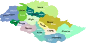
| # | District | Headquarters | Area (km²) | Population (1998) | Division |
|---|---|---|---|---|---|
| 1 | Ghanche | Khaplu | 6,400 | 88,366 | Baltistan |
| 2 | Skardu | Skardu | 15,000 | 214,848 | Baltistan |
| 3 | Astore | Eidgah | 8,657 | 71,666 | Diamer |
| 4 | Diamer | Chilas | 10,936 | 131,925 | Diamer |
| 5 | Ghizer | Gahkuch | 9,635 | 120,218 | Gilgit |
| 6 | Gilgit | Gilgit | 38,000 | 243,324 | Gilgit |
| 7 | Hunza | Aliabad | 17,145 | 80,355 | Gilgit |
| 8 | Kharmang | Tolti | 20,000[23] | Baltistan | |
| 9 | Shigar | Shigar | 8,500 | 109,000 | Baltistan |
| 10 | Nagar | Nagar | 15,567 | 89,420 | Gilgit |
| 11 | Gupis–Yasin | Phander? | Gilgit | ||
| 12 | Tangir | Tangir | Diamer | ||
| 13 | Darel | Darel | Diamer | ||
| 14 | Roundu | Dambudas | Baltistan |
See also
- Administrative units of Pakistan
- List of Pakistani Districts by Human Development Index
Notes
- No data is available on the recently created districts of Sindh Province.
- No data is available on the recently created district of Nankana, which was part of Sheikhupura District.
All the figures require being re-checked. Data entry error has occurred in Sindh Province.
References
- "DISTRICT WISE CENSUS RESULTS CENSUS 2017" (PDF). www.pbscensus.gov.pk. Archived from the original (PDF) on 29 August 2017. Retrieved 3 September 2017.
- "Dividing governance: Three new districts notified in G-B - The Express Tribune". The Express Tribune. 26 July 2015. Retrieved 5 April 2019.
- "Administrative Setup". ajk.gov.pk. Archived from the original on 9 April 2010. Retrieved 17 May 2010.
- "Four new districts in Sindh". Daily Times. 11 December 2004. Archived from the original on 11 December 2013. Retrieved 16 February 2014.
- "Nankana becomes district". Dawn.Com. 10 May 2005. Retrieved 16 February 2014.
- "Thatta (District, Pakistan) - Population Statistics, Charts, Map and Location". citypopulation.de.
- http://www.pbs.gov.pk/sites/default/files/PAKISTAN%20TEHSIL%20WISE%20FOR%20WEB%20CENSUS_2017.pdf
- "Districts". Balochistan.gov.pk. Retrieved 16 February 2014.
- "Government". Khyberpakhtunkhwa.gov.pk. Archived from the original on 3 August 2012. Retrieved 16 February 2014.
- "Districts | Punjab Portal". Punjab.gov.pk. 16 January 2014. Retrieved 16 February 2014.
- "Map of Sindh". Government of Sindh. Retrieved 16 February 2014.
- http://www.pbs.gov.pk/sites/default/files/PAKISTAN%20TEHSIL%20WISE%20FOR%20WEB%20CENSUS_2017.pdf
- http://www.pbs.gov.pk/sites/default/files/PAKISTAN%20TEHSIL%20WISE%20FOR%20WEB%20CENSUS_2017.pdf
- "Pakistan Bureau of Statistics - 6th Population and Housing Census". www.pbscensus.gov.pk. Archived from the original on 15 October 2017. Retrieved 8 September 2017.
- "Home - Government of Balochistan" (PDF). balochistan.gov.pk. Retrieved 1 June 2018.
- "Country escapes major earthquake damage". Daily Times. 20 January 2011. Archived from the original on 11 December 2013. Retrieved 16 February 2014.
- "Harnai is new district of Balochistan". Dawn.Com. 31 August 2007. Retrieved 16 February 2014.
- "Kharan and Noshki District" (PDF). American Refugee Committee. July 2007. Archived from the original (PDF) on 25 July 2011. Retrieved 16 February 2014.
- "Sujawal (District, Pakistan) - Population Statistics, Charts, Map and Location". citypopulation.de.
- "Historically & Geographically". District Government Umerkot. Archived from the original on 24 February 2012. Retrieved 16 February 2014.
- Azad Government of Jammu & Kashmir, Muzaffarabad, 2019.
- Azad Government of Jammu & Kashmir, Muzaffarabad, 2019.
- "Archived copy". Archived from the original on 24 November 2015. Retrieved 12 December 2015.CS1 maint: archived copy as title (link)
Further reading
- Population Census Organization, Government of Pakistan. "List of Districts/Agencies/Tribal Areas". Archived from the original on 19 December 2010. Retrieved 14 April 2006.
- Population Census Organization, Government of Pakistan. "List of Tehsils/Talukas with respect to their Districts". Archived from the original on 30 December 2010. Retrieved 14 April 2006.
- Country Profiles, South Asian Media Net. "Pakistan >> District Profiles". Archived from the original on 18 May 2011. Retrieved 14 April 2006.
- "District Governments of Sindh". Local Government Department, Government of Sindh. Archived from the original on 26 November 2009. Retrieved 16 February 2014.
External links
- List of districts from the Population Census Organization (Government of Pakistan)
| ||||||||||||||||||||||||||
| ||||||||||||||||||||||||||
| ||||||||||||||||||||||||||
| ||||||||||||||||||||||||||
| ||||||||||||||||||||||||||
| ||||||||||||||||||||||||||
| ||||||||||||||||||||||||||
| ||||||||||||||||||||||||||
| ||||||||||||||||||||||||||