Gillespie Gap
Gillespie Gap (el. 2,805 ft (855 m)), also known as Etchoe Pass, is a mountain pass along the Blue Ridge Mountains. Historically, two events occurred at the pass. The first was in 1761 when thirty men, under the command of Francis Marion, were sent to dislodge an encampment of Cherokee warriors at the pass; ambushed, Marion lost twenty-one men. The second was in 1780 when the Overmountain Men crossed the pass on their way to Kings Mountain.[2]
| Gillespie Gap | |
|---|---|
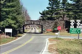 NC 226/NC 226A intersect at Gillespie Gap | |
| Elevation | 2,805 ft (855 m)[1] |
| Traversed by | Blue Ridge Parkway |
| Location | North Carolina United States |
| Range | Blue Ridge Mountains |
| Coordinates | 35°51′09″N 82°03′03″W |
| Topo map | USGS Little Switzerland |

NC 226 traverses through the gap, which connects Marion and Spruce Pine. Intersecting at the gap is NC 226A, which goes to nearby Little Switzerland. The Blue Ridge Parkway also passes through the gap, providing scenic views along the adjacent ridge lines. The gap is also along the Eastern Continental Divide and the McDowell–Mitchell county line.
References
- "Gillespie Gap". Geographic Names Information System. United States Geological Survey. Retrieved March 21, 2016.
- Rozema, Vicki (2007). Footsteps of the Cherokees (Second ed.). John F. Blair. ISBN 978-0-89587-346-0.