McDowell County, North Carolina
McDowell County is a county located in the U.S. state of North Carolina. As of the 2010 census, the population was 44,996.[1] Its county seat is Marion.[2]
McDowell County | |
|---|---|
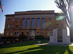 McDowell County Courthouse in Marion | |
Seal | |
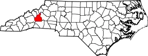 Location within the U.S. state of North Carolina | |
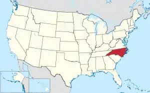 North Carolina's location within the U.S. | |
| Coordinates: 35°41′N 82°03′W | |
| Country | |
| State | |
| Founded | 1842 |
| Named for | Joseph McDowell |
| Seat | Marion |
| Largest city | Marion |
| Area | |
| • Total | 446 sq mi (1,160 km2) |
| • Land | 441 sq mi (1,140 km2) |
| • Water | 5.4 sq mi (14 km2) 1.2%% |
| Population | |
| • Estimate (2018) | 45,507 |
| • Density | 102/sq mi (39/km2) |
| Time zone | UTC−5 (Eastern) |
| • Summer (DST) | UTC−4 (EDT) |
| Congressional district | 11th |
| Website | www |
McDowell County comprises the Marion, NC Micropolitan Statistical Area, which is also included in the Hickory-Lenoir, NC Combined Statistical Area.
History
Archaeological excavations performed by Dr. David Moore during the early 1980s, revealed artifacts and other evidence that the earliest inhabitants of McDowell County lived there from the Woodland period and Mississippian culture era, from 250 to 1500CE. Dr. Moore discovered this material in an area close to the Catawba River, in and around an unusual topographical site known as Round Hill. Both the historic Cherokee and Catawba Indians were Native American peoples known to live in what is now McDowell County, and they had been there long before any Europeans. These Native Americans were living in this section for centuries before the Spanish Juan Pardo's 1566 expedition to the interior region from the Atlantic coast.
In the next two years, Pardo traveled from the Spanish colony on an island, through what are now South Carolina and Western North Carolina and into southeastern Tennessee. His expedition traveled through the area that is now McDowell County. His purpose was to acquire territory for Spain and establish forts for an alternative interior route to central Mexico. The Spanish mistakenly believed that the Appalachians connected to a range there, where they had established silver mines.[3][4]
Pardo also hoped to find precious metals during his expedition, in which he stopped at several Native American villages. Pardo and his men built a log blockhouse, Fort San Juan, at a Mississippian chiefdom known as Joara at the headwaters of the Catawba River, a site north of present-day Morganton, North Carolina. They wintered over at Joara.[5] Pardo directed his forces to establish five more forts in the interior, including one at Chiaha, in present-day southeastern Tennessee. The Native Americans resisted poor treatment by the Spanish and killed all but one of the soldiers in the garrisons, burning all six forts in 1568. Pardo had already left for Spain by then. The Spanish gave up their efforts to colonize the interior.[6][7]
In 1748, "Hunting" John McDowell received a land grant from the colony of North Carolina for property known today as Pleasant Gardens, including acreage that originally extended from Swan's Pond (Catawba County) up the Catawba River west to present-day Marion and into the region known as Buck Creek. McDowell went hunting with his friend Henry Weidner, and the two came upon a lush green valley with thousands of acres of what they thought was virgin forest. They were both interested in the land, and McDowell won a wrestling match to decide who should apply for it.
McDowell settled here with his family, and received two more land grants. established residence here family, and subsequently received two land grants. He is noted in Max Dixon's book, The Wataugans, as being instrumental in Jacob Brown's purchase of one of the last remaining pieces of acreage along the Nolichucky River in eastern Tennessee. McDowell hosted negotiations with the Cherokee from that area on his farm in North Carolina.
His son, Joseph McDowell, fought in the Battle at Kings Mountain. McDowell County is named in his honor. Today, McDowell's home survives, one of the few remaining that was built by its namesake.
The settlement of what was known as Old Fort took place nearby; this became for a time the westernmost outpost of colonial society. These early pioneers established a community protected by a series of forts that were used into the early 19th century.
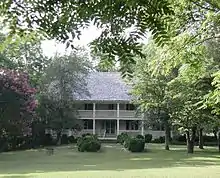
In 1793, Colonel John Carson built a plantation house near Buck Creek in the Pleasant Gardens community. It is known as the historic Carson House. He also operated gold mines in the southern part of the county. Colonel Carson had contributed to the Patriot cause in the American Revolutionary War.
Marion, the county seat of McDowell County, was planned and built on land selected by the first McDowell County Commissioners when they met on March 14, 1844 at the Carson House. It was not until 1845, however, that Marion was designated as the county seat by the state legislature. The settlement was named after Francis Marion, the American Revolutionary War hero known as the "Swamp Fox."
He was the subject of the dramatic movie The Patriot (2000). The historic movie The Last of the Mohicans (1992), based on a novel by James Fenimore Cooper, was set in New York state, but it was filmed along the shores of Lake James.
During the Carolina Gold Rush period of the early 19th century, the south county area was known for its gold production. The banks of the Muddy Creek and mines at Vein Mountain were productive areas. Many mines and thriving gold rush towns such as Brackettown no longer exist; scattered ruins and abandoned cemeteries mark once-active sites of the gold rush period. An old mine in Woodlawn is from this period.
McDowell County was first formed in 1842 from parts of Burke County and Rutherford County. It was named for Joseph McDowell, a Revolutionary War leader and hero of the Battle of King's Mountain. He was elected and served one term as a member of the United States House of Representatives, from 1797 to 1799.
In 1861, parts of McDowell, Burke, Caldwell, Watauga, and Yancey counties were combined to form Mitchell County. McDowell County is rich in American Civil War History.
Geography
According to the U.S. Census Bureau, the county has a total area of 446 square miles (1,160 km2), of which 441 square miles (1,140 km2) is land and 5.4 square miles (14 km2) (1.2%) is water.[8]
Numerous small creeks and streams flow through the county. The Catawba River crosses the county and empties into Lake James. It flows over Catawba Falls on its way, which is accessible to the public. Other waterfalls can be found in the county, such as Toms Creek Falls. Almost half of the county, including the two aforementioned waterfalls, is located inside the Pisgah National Forest. Linville Caverns, North Carolina's only limestone cavern system open to the public, is located in the far northern part of the county.
Geologically, McDowell County is located within the southern Appalachian Mountains region. The Blue Ridge Parkway closely follows the northwestern boundary of the county. McDowell County rises rapidly from the Piedmont (United States) in its extreme eastern border where elevations average about 1200 feet above sea level, to the Blue Ridge Mountains in the north and west. Its lowest point is 969 feet above sea level along Cane Creek in the county's southeastern corner. Its highest point is Pinnacle—at 5,665 feet above sea level the second-highest mountain (after Grandfather Mountain) in the Blue Ridge, and also considered the southernmost tip of the Black Mountains, the highest ridge in eastern America. Much of the county lies in the Foothills (North Carolina) region of Western North Carolina.
Adjacent counties
- Mitchell County - north
- Avery County - north
- Burke County - east
- Rutherford County - south
- Buncombe County - west
- Yancey County - northwest
Protected areas
- Blue Ridge Parkway (part)
- Pisgah National Forest (part)
- South Mountains Game Land (part)
- Lake James State Park (part)
- Bobs Creek State Natural Area
- Fonta Flora State Trail (part)
- Wilderness Gateway State Trail (part)
Demographics
| Historical population | |||
|---|---|---|---|
| Census | Pop. | %± | |
| 1850 | 6,246 | — | |
| 1860 | 7,120 | 14.0% | |
| 1870 | 7,592 | 6.6% | |
| 1880 | 9,836 | 29.6% | |
| 1890 | 10,939 | 11.2% | |
| 1900 | 12,567 | 14.9% | |
| 1910 | 13,538 | 7.7% | |
| 1920 | 16,763 | 23.8% | |
| 1930 | 20,336 | 21.3% | |
| 1940 | 22,996 | 13.1% | |
| 1950 | 25,720 | 11.8% | |
| 1960 | 26,742 | 4.0% | |
| 1970 | 30,648 | 14.6% | |
| 1980 | 35,135 | 14.6% | |
| 1990 | 35,681 | 1.6% | |
| 2000 | 42,151 | 18.1% | |
| 2010 | 44,996 | 6.7% | |
| 2018 (est.) | 45,507 | [9] | 1.1% |
| U.S. Decennial Census[10] 1790-1960[11] 1900-1990[12] 1990-2000[13] 2010-2013[1] | |||
As of the census[14] of 2000, there were 42,151 people, 16,604 households, and 11,954 families residing in the county. The population density was 95 people per square mile (37/km2). There were 18,377 housing units at an average density of 42 per square mile (16/km2). The racial makeup of the county was 92.18% White, 4.16% Black or African American, 0.29% Native American, 0.92% Asian, 0.01% Pacific Islander, 1.61% from other races, and 0.84% from two or more races. 2.88% of the population were Hispanic or Latino of any race.
There were 16,604 households, out of which 30.30% had children under the age of 18 living with them, 57.50% were married couples living together, 10.20% had a female householder with no husband present, and 28.00% were non-families. 24.30% of all households were made up of individuals, and 10.30% had someone living alone who was 65 years of age or older. The average household size was 2.45 and the average family size was 2.90.
In the county, the population was spread out, with 22.80% under the age of 18, 8.20% from 18 to 24, 29.90% from 25 to 44, 24.90% from 45 to 64, and 14.30% who were 65 years of age or older. The median age was 38 years. For every 100 females there were 99.30 males. For every 100 females age 18 and over, there were 97.70 males.
The median income for a household in the county was $32,396, and the median income for a family was $37,789. Males had a median income of $26,609 versus $21,640 for females. The per capita income for the county was $16,109. About 9.00% of families and 11.60% of the population were below the poverty line, including 15.10% of those under age 18 and 15.70% of those age 65 or over.
Communities
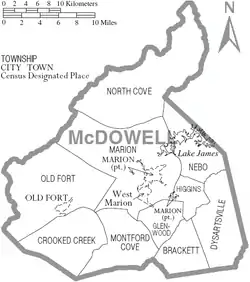
City
- Marion (county seat)
Town
Census-designated place
Unincorporated communities
- Glenwood
- Linville Falls
- Little Switzerland
- Nebo
- North Cove
Townships
- Crooked Creek
- Dysartsville
- Glenwood
- Marion
- Montford Cove
- Nebo
- North Cove
- Old Fort
- Pleasant Gardens
- Sugar Hill
- Woodlawn-Sevier
Law and government
McDowell County is a member of the Isothermal Planning and Development Commission regional council of governments.
Politics
McDowell voted Republican in the three elections from 1900 to 1908, but otherwise was solidly Democratic until 1956 when Dwight D. Eisenhower carried the county. Since then, like other areas of the Foothills, it has become powerfully Republican. Since 1956, only Lyndon Johnson in 1964 and Jimmy Carter in 1976, both hailing from the southern region of the nation, have won the county.
| Year | Republican | Democratic | Third parties |
|---|---|---|---|
| 2016 | 73.3% 14,568 | 23.5% 4,667 | 3.2% 640 |
| 2012 | 65.1% 11,775 | 33.3% 6,031 | 1.6% 293 |
| 2008 | 62.7% 11,534 | 35.7% 6,571 | 1.5% 281 |
| 2004 | 66.2% 10,590 | 33.3% 5,330 | 0.5% 82 |
| 2000 | 65.0% 9,109 | 33.9% 4,747 | 1.1% 155 |
| 1996 | 52.2% 6,407 | 37.1% 4,553 | 10.7% 1,318 |
| 1992 | 45.8% 6,090 | 39.9% 5,309 | 14.3% 1,896 |
| 1988 | 59.3% 6,526 | 40.5% 4,449 | 0.2% 22 |
| 1984 | 65.1% 7,639 | 34.7% 4,076 | 0.2% 21 |
| 1980 | 53.6% 5,680 | 44.3% 4,703 | 2.1% 223 |
| 1976 | 41.4% 4,450 | 58.1% 6,246 | 0.5% 50 |
| 1972 | 72.1% 6,570 | 25.8% 2,348 | 2.2% 196 |
| 1968 | 46.0% 4,740 | 24.7% 2,543 | 29.3% 3,018 |
| 1964 | 39.8% 4,174 | 60.2% 6,314 | |
| 1960 | 55.7% 6,148 | 44.3% 4,889 | |
| 1956 | 55.5% 5,468 | 44.5% 4,392 | |
| 1952 | 49.8% 4,710 | 50.2% 4,755 | |
| 1948 | 37.9% 2,709 | 53.2% 3,805 | 8.9% 638 |
| 1944 | 36.0% 2,258 | 64.0% 4,008 | |
| 1940 | 29.5% 2,216 | 70.5% 5,290 | |
| 1936 | 36.8% 3,114 | 63.2% 5,352 | |
| 1932 | 33.8% 2,478 | 65.7% 4,810 | 0.5% 35 |
| 1928 | 50.0% 3,423 | 50.0% 3,430 | |
| 1924 | 45.9% 2,590 | 53.6% 3,023 | 0.4% 25 |
| 1920 | 47.7% 2,561 | 52.3% 2,809 | |
| 1916 | 48.8% 1,218 | 51.1% 1,274 | 0.1% 2 |
| 1912 | 15.9% 343 | 47.9% 1,037 | 36.2% 783 |
2016 presidential primaries and election
In the 2016 Republican Primary in McDowell County, Donald Trump received 2,552 votes (or 41.2% of the total votes) followed by Ted Cruz who came in second with 2,422 votes (or 39.1% of the total votes). In the 2016 Democratic Primary, Bernie Sanders received 1,622 votes (49.0%) and Hillary Clinton received 1,353 votes (40.9%).[16]
In the 2016 presidential election in McDowell County, Republican Donald Trump received 14,517 votes (74.2%), Democrat Hillary Clinton 4,645 votes (23.8%), and Libertarian Gary Johnson 395 votes (2.0%).[17]
Education

The following is a list of schools located in McDowell County:
- Marion Elementary School
- West Marion Elementary School
- Nebo Elementary School
- Old Fort Elementary School
- Pleasant Gardens Elementary School
- Eastfield Global Magnet School
- Glenwood Elementary School
- North Cove Elementary School
- West McDowell Middle School
- East McDowell Middle School
- Foothills Community School
- McDowell High School (Marion, North Carolina)
- McDowell Early College High School (Marion, North Carolina)
- McDowell Academy for Innovation (Marion, North Carolina)
- Phoenix Academy
- New Manna Christian School
- Nebo Crossing Christian Academy
McDowell County has a 1 community college: McDowell Technical Community College
References
- "State & County QuickFacts". United States Census Bureau. Archived from the original on June 6, 2011. Retrieved October 27, 2013.
- "Find a County". National Association of Counties. Archived from the original on May 31, 2011. Retrieved 2011-06-07.
- Charles Hudson (28 July 2005). The Juan Pardo Expeditions: Exploration of the Carolinas and Tennessee, 1566-1568. University of Alabama Press. ISBN 978-0-8173-5190-8.
- Glanville, Jim (2009). "16th Century Spanish Invasions of Southwest Virginia" (PDF). Historical Society of Western Virginia Journal. 18 (1): 34–42. Retrieved 2013-12-27.
- Beck, Robin A., Jr.; Moore, David G.; Rodning, Christopher B. (2006). "Identifying Fort San Juan: A Sixteenth-Century Spanish Occupation at the Berry Site, North Carolina" (PDF). Southeastern Archaeology. 25 (1): 65–77. Retrieved 2013-12-27.
- "Marker: N–47 – FORT SAN JUAN". North Carolina Highway Historical Marker Program. North Carolina Department of Cultural Resources. Retrieved August 17, 2013.
- John Noble Wilford (July 23, 2013). "Fort Tells of Spain's Early Ambitions". The New York Times. Retrieved August 17, 2013.
- "2010 Census Gazetteer Files". United States Census Bureau. August 22, 2012. Archived from the original on January 12, 2015. Retrieved January 18, 2015.
- "Population and Housing Unit Estimates". Retrieved July 22, 2019.
- "U.S. Decennial Census". United States Census Bureau. Retrieved January 18, 2015.
- "Historical Census Browser". University of Virginia Library. Retrieved January 18, 2015.
- Forstall, Richard L., ed. (March 27, 1995). "Population of Counties by Decennial Census: 1900 to 1990". United States Census Bureau. Retrieved January 18, 2015.
- "Census 2000 PHC-T-4. Ranking Tables for Counties: 1990 and 2000" (PDF). United States Census Bureau. April 2, 2001. Retrieved January 18, 2015.
- "U.S. Census website". United States Census Bureau. Retrieved 2008-01-31.
- Leip, David. "Dave Leip's Atlas of U.S. Presidential Elections". uselectionatlas.org.
- "North Carolina Primary Election Results 2016". 29 September 2016 – via NYTimes.com.
- 2016 Election Results
External links
- McDowell County government official website
- NCGenWeb McDowell County - free genealogy resources for the county
- McDowell Tourism
- Discover McDowell County
Places adjacent to McDowell County, North Carolina | ||||||||||
|---|---|---|---|---|---|---|---|---|---|---|
| ||||||||||
Municipalities and communities of McDowell County, North Carolina, United States | ||
|---|---|---|
| City | 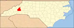 McDowell County map | |
| Town | ||
| CDP | ||
| Unincorporated communities |
| |
| Footnotes | ‡This populated place also has portions in an adjacent county or counties | |
| ||

| Authority control |
|---|