Eastern Continental Divide
The Eastern Continental Divide or Eastern Divide or Appalachian Divide is a hydrographic divide in eastern North America that separates the easterly Atlantic Seaboard watershed from the westerly Gulf of Mexico watershed. The divide nearly spans the United States from south of Lake Ontario through the Florida peninsula, and consists of raised terrain including the Appalachian Mountains to the north, the southern Piedmont Plateau and lowland ridges in the Atlantic Coastal Plain to the south. Water including rainfall and snowfall, lakes, streams and rivers on the eastern/southern side of the divide drains to the Atlantic Ocean; water on the western/northern side of the divide drains to the Gulf of Mexico. The ECD is one of six continental hydrographic divides of North America which define several drainage basins, each of which drains to a particular body of water.
The divide originates at the Eastern Triple Divide(see sidebar) near the middle of the northern border of Pennsylvania then runs generally south-by-southwest following the crest of the Appalachian Mountains through Pennsylvania, western Maryland, West Virginia, Virginia and North Carolina to its high point on Grandfather Mountain (though Mount Mitchell is the highest point in the Appalachian Mountains, it is not on the ECD, but 4 miles west of the ECD), then descends [1] to the city of Atlanta in northwestern Georgia, where it doglegs southeasterly across the Georgia plateau and through the lowlands of Northern Florida to its terminus in central Florida at the northern boundary of the Lake Okeechobee Basin(see sidebar).
Though the divide is often associated with high elevation, at its southern terminus at the northern Kissimmee River watershed in Florida, the elevation is only 70ft. above sea level.[2] Nor does the divide always coincide with the highest point or ridgeline, because streams can flow through passes or gaps in the ridge, so that terrain on one side of the ridge drains to the other side and therefore to the other watershed. This occurs in several places. The ECD is not completely fixed, but can shift due to erosion, tectonic shift and also anthropogenic activity such as tunnel excavation, damming of rivers and road construction.
In colonial times, except for Spanish Florida, the ECD served as the boundary between English colonies on the Atlantic seaboard and Indian lands to the interior.
Description
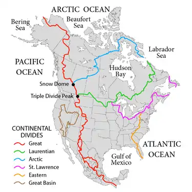
The Eastern Triple Divide[lower-alpha 1] is the northern terminus of the Eastern Continental Divide where it intersects the northeasterly St. Lawrence Divide near the middle of the northern border of Pennsylvania. That point divides the eastern United States into three watersheds, where the associated nearby headwaters form the Pine Creek tributary of West Branch Susquehanna River that drains to the Atlantic ocean, the Allegheny River tributary of the Ohio River that drains to the Gulf of Mexico, and the Genesee River tributary of Lake Ontario that drains to the Gulf of Saint Lawrence.
The Eastern Continental Divide originates in the north at the Eastern Triple Divide on the summit named 'Triple Divide Peak' 10.4 mi (16.7 km) south of the New York-Pennsylvania line about 5 mi. southwest of the borough of Ulysses in Potter County, Pennsylvania. That summit is the northernmost peak of three atop a broad plateau which is currently farmland. From there, the ECD runs south-southwest through the two nearby southern summits then southwesterly along the Allegheny Plateau west of the Allegheny Front until it plunges south along the Appalachians barrier ridge. Mount Mitchell State Park in North Carolina is the highest point on the ECD at 6,366 ft (1,940 m). As the altitude of the peaks diminishes across the swampy Georgia plateau, the divide meanders into the low country of Northern Florida until it reaches central Florida, ending at the north bank watershed of the Kissimmee River.
While notionally, the ECD may be considered to extend to the southern tip of Florida, south of Lake Okeechobee the everglades, which spans the length and breadth of the peninsula, is a seasonal swamp which drains into the lake. During the wet season, overflow from the lake forms an unchanneled "river" 100 miles long and 60 miles wide that flows south to Florida Bay which ostensibly drains into the Gulf of Mexico, but due to mud dykes, little exchange of water actually occurs. So hydrographically, the only divide in southern Florida is between the lake and the ocean or Gulf, and that divide is coincident with the boundary between land and sea.
Because the divide represents the highest terrain, air is forced upwards regardless of wind direction. This process of orographic enhancement leads to higher precipitation than surrounding areas. In winter, the divide is often much snowier than surrounding areas, due to orographic enhancement and cooler temperatures with elevation.
The Lake Okeechobee drainage basin in south central Florida, including the Kissimmee River drainage basin to the north which feeds it, was naturally or hydrographically, an endorheic basin, one which does not have outflow to another body of water like a river or ocean. Such a basin may form a swamp when water collects. It was altered by anthropogenic activity, specifically the construction of the Okeechobee canal in 1937 which spanned the Atlantic Ocean, the lake and the Gulf of Mexico. Nonetheless, it is not considered by hydrologists to be part of either the Gulf of Mexico watershed or Atlantic seaboard watershed. The northern boundary of the basin[lower-alpha 2] is the southern terminus of the Eastern Continental divide.
History
Prior to about 1760, north of Spanish Florida, the Appalachian Divide represented the boundary between British and French colonial possessions in North America. [5] The Royal Proclamation of 1763 separated settled lands of the Thirteen Colonies from lands north and west of it designated the Indian Reserve; the proclamation border ran along the Appalachian Divide but extended beyond its Pennsylvania-New York terminus north into New England.
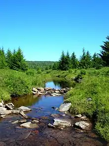 Red Creek west of the crest of the Allegheny Front in the Dolly Sods area of West Virginia; the creek originates along the Eastern Continental Divide, with its waters flowing to the Gulf of Mexico as part of the Ohio River watershed. |
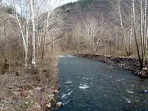 Seneca Creek, incised into the Allegheny Front west of Seneca Rocks, West Virginia. This short but steep creek originates along the Eastern Continental Divide; its waters flow into the Atlantic Ocean via the Potomac River and Chesapeake Bay. |
Locations
| Area | Point | Summit or other feature |
|---|---|---|
| Pennsylvania: Eastern Triple Divide | 2,523 feet (769 m) 41°50′48″N 77°50′14″W |
Triple Divide Peak, Ulysses Township, Potter County |
| Pennsylvania: Babcock Ridge | ||
| Pennsylvania: Allegheny Mountain | 2,167 feet (661 m) 40°28′53″N 78°33′01″W |
summit near Allegheny/Gallitzin Tunnels |
| Pennsylvania: Allegheny Mountain | 2,690 feet (820 m) 39°57′41″N 78°51′24″W |
summit above Allegheny Mountain Tunnel (Pennsylvania Turnpike) |
| Pennsylvania: Allegheny Mountain | 2,460 feet (750 m) 39°48′37″N 78°57′38″W |
summit above Sand Patch Tunnel |
| Pennsylvania: Savage Mountain | 2,392 feet (729 m)[6]39°45′12″N 78°54′58″W | railroad cut on Great Allegheny Passage |
| Pennsylvania/Maryland: Savage Mountain | 2,840 feet (870 m) 39°43′21″N 78°54′51″W |
highest summit of the Mason–Dixon Line |
| Maryland: Interstate 68 | 2,620 feet (800 m) 39.6828°N 79.037704°W |
crossing near Green Lantern Road |
| Maryland: Savage Mountain | 2,600 feet (790 m) 39°30′27″N 79°13′9″W |
saddle point at planned route of 1828 C&O Canal |
| Maryland/West Virginia: Backbone Mountain | 3,380 feet (1,030 m) 39°14′15″N 79°29′8″W (highest point) |
Headwaters of Potomac River (Maryland's southern border) and Youghiogheny River |
| West Virginia: US Route 33 / State Route 55 | 3,295 feet (1,004 m) 38.892050°N 79.467781°W |
Saddle Point at Pendleton County and Randolph County. |
| West Virginia: Interstate 64 | 2,460 feet (750 m) 37.787539°N 80.224528°W |
Midland Trail: planned crossing for the 19th century James River and Kanawha Turnpike |
| Virginia: Jefferson National Forest | 3,620 feet (1,100 m) 37°20′27″N 80°32′4″W |
saddle point at Johns Creek headwaters (James River tributary), and near triple point of Mississippi River (W) & Chesapeake Bay (NE)/Albemarle Sound (Roanoke River) (SE) |
| Virginia: Appalachian Trail | 3,397 feet (1,035 m) 37.380422°N 80.306368°W |
Parallel Route Begin |
| Virginia: Blacksburg, Virginia | 2,080 feet (630 m) |
|
| Virginia: Appalachian Trail | 3,224 feet (983 m) 37.343516°N 80.364647°W |
Parallel Route Begin |
| Virginia: Interstate 81 | 2,180 feet (660 m) 37.128708°N 80.371299°W |
crossing |
| Virginia: Christiansburg, Virginia | 2,180 feet (660 m) 37.094853°N 80.445558°W |
2940 Riner Rd, Christiansburg, VA 24073 |
| Virginia: Interstate 77 | 2,860 feet (870 m) 36.650896°N 80.705609°W |
crossing |
| North Carolina: U.S. Route 21 | 2,692 feet (821 m) 36.396259°N 80.986289°W |
crossing at Roaring Gap, NC |
| North Carolina: Thurmond Chatham Wildlife Management Area | 36.377344°N 81.220722°W | triple point of New River and Yadkin/West Prong Roaring rivers |
| North Carolina: North Carolina Highway 105 | 4,020 feet (1,230 m) 36.118190°N 81.838560°W |
crossing |
| North Carolina: North Carolina Highway 226 and Blue Ridge Parkway | 2,820 feet (860 m) 35.85266°N 82.0507166°W |
crossing |
| North Carolina: Interstate 40 | 2,786 feet (849 m) 35.618233°N 82.263007°W |
crossing |
| North Carolina: U.S. Route 74A | 2,880 feet (880 m) 35.488843°N 82.358308°W |
crossing |
| North Carolina: Interstate 26 | 2,130 feet (650 m) 35.290048°N 82.40193°W |
crossing |
| North Carolina: U.S. Route 276 | 2,910 feet (890 m) 35.129807°N 82.63921°W |
crossing |
| North Carolina: U.S. Route 178 | 2,694 feet (821 m) 35.096133°N 82.80940°W |
crossing, approx. 1 mile north of NC/SC border |
| North Carolina–South Carolina: French Broad watershed | tributary of the Tennessee River along NC/SC border dividing mountain ridges running southeast meets Santee watershed flowing into Atlantic | |
| North Carolina–South Carolina: Sassafras Mountain | 3,564 feet (1,086 m) 35°03′53″N 82°46′38″W |
located along the South Carolina-North Carolina border in northern Pickens County, South Carolina and southern Transylvania County, North Carolina nearest to the town of Rosman, North Carolina |
| North Carolina: U.S. Route 64 | 2,694 feet (821 m) 35.125507°N 82.910831°W |
crossing |
| North Carolina–South Carolina: Savannah watershed | across the border of Pickens County, South Carolina & Greenville County, South Carolina up into Transylvania County, North Carolina, Jackson County, North Carolina, and Macon County, North Carolina to dividing mountain ridges to Tennessee River tributaries | |
| North Carolina: Highlands, North Carolina | 4,100 feet (1,200 m) 35°2′48.0408″N 83°11′13.434″W |
Sunset Rock |
| North Carolina: North Carolina Highway 28 | 3,771 feet (1,149 m) 35.040808°N 83.202295°W |
crossing |
| North Carolina: Cowee Gap | 4,199 feet (1,280 m) 35°05′27″N 83°08′52″W |
divides Tennessee (Cullasaja) and Savannah (Chatooga) rivers |
| Georgia: Black Rock Mountain State Park | 3,640 feet (1,110 m) 34.91472°N 83.34389°W |
a Blue Ridge summit |
| Georgia: ACF River Basin at Young Lick | 3,809 feet (1,161 m) 34°49′22″N 83°39′09″W |
triple point at intersection of 3 GA counties: Hiwassee (Towns Co)/Chattahoochee River (Habersham Co) on the west & on the east: Savannah River (Rabun Co) |
| Georgia: Altamaha watershed | triple point along border of Hall & Banks (GA) counties: Chattahoochee River-Banks (west) & Altamaha River-Hall/Savannah River-Banks (east) | |
| Georgia: Suwanee watershed | triple point: Chattahoochee River/Suwanee Creek (west) & Altamaha River (east) | |
| Georgia: Interstate 85 | 1,280 feet (390 m) 34.075235°N 83.917737°W |
crossing (1 of 5) |
| Georgia: Interstate 85 | 1,120 feet (340 m) 33.998098°N 84.07661°W |
crossing (2 of 5) |
| Georgia: Norcross, Georgia | through Norcross historic district | |
| Georgia: Interstate 85 | 1,050 feet (320 m) 33.912202°N 84.207973°W |
crossing (3 of 5) |
| Georgia: Interstate 285 | 1,020 feet (310 m) 33.803115°N 84.250031°W |
crossing (1 of 2) |
| Georgia: Atlanta | near Dekalb Av | |
| Georgia: Interstate 75/Interstate 85 | 1,020 feet (310 m) 33.752354°N 84.37942°W |
crossing (1 of 4 crossings of I-75/4 of 5 crossings of I-85) |
| Georgia: Interstate 20 | 1,050 feet (320 m) 33.741221°N 84.410663°W |
crossing |
| Georgia: Interstate 85 | 1,000 feet (300 m) 33.661782°N 84.4274°W |
crossing (5 of 5) |
| Georgia: Interstate 75 | 976 feet (297 m) 33°39′19.60″N 84°23′42.52″W |
crossing (2 of 4) |
| Georgia: Interstate 285 | 960 feet (290 m) 33°37′51.56″N 84°23′34.40″W |
crossing (2 of 2) |
| Georgia: Interstate 75 | 927 feet (283 m) 33°34′29.77″N 84°20′7.67″W |
crossing (3 of 4) |
| Georgia: Atlantic Seaboard fall line | near Macon, Georgia, this intersection is a triple physiographic point of the Piedmont (to the north) and the Gulf & Atlantic coastal plains (southwest & southeast). | |
| Georgia: Interstate 75 | 410 feet (120 m) 32°10′16.10″N 83°45′9.25″W |
crossing (4 of 4) |
| Georgia: Satilla watershed | triple point: Suwannee (west) & Altamaha River/Satilla River (east) | |
| Georgia: St. Marys watershed | triple point: Suwannee (west) & Satilla River/St. Marys River (east) | |
| Florida: St. Johns watershed | triple point: Suwannee (west) & St. Marys River/St. Johns River (east) | |
| Florida: Interstate 10 | 159 feet (48 m) 30°15′14.64″N 82°23′57.84″W |
crossing |
| Florida: Florida Trail | Central Florida crossing over the Florida crustal arch | |
| Florida: Withlacoochee watershed | triple point: Suwannee/Withlacoochee River (Florida) (west) & St. Johns River (east) | |
| Florida: Miami watershed | triple point: Withlacoochee (west) & St. Johns River/Miami River (east) | |
| Florida: Kissimmee/Okeechobee watershed | south point of ECD @ Withlacoochee & Miami/Kissimmee triple point | |
See also
Divides
- Continental Divide of the Americas
- Laurentian Divide
- Saint Lawrence River Divide
- Great Basin Divide
- Arctic Divide
Triple points
- Eastern Triple Divide
Notes
- @41°50′48″N 77°50′14″W, elevation: 2,507 feet (764 m) [3]
- the headwaters of Boggy Creek just southwest of Orlando International Airport including Mud Lake @28°23′24″N 81°17′30″W and Marie Prairie @28°24′51″N 81°18′07″W[4]
References
- with a short stretch along the border of South Carolina
- at headwaters of Boggy Creek (East Lake Tohopekaliga) just south of Orlando International Airport
- "Triple Divide". Geographic Names Information System. United States Geological Survey.
- GNIS
- Alvin M. Josephy, Jr., ed. (1961). The American Heritage Book of Indians. The editors of American Heritage Magazine. American Heritage Publishing Co., Inc. LCCN 61-14871., pages 180-211, 188-189
- "Elevation Chart". The Great Allegheny Passage: The Cumberland and Pittsburgh Trail. Allegheny Trail Alliance. Archived from the original on May 6, 2009. Retrieved 2009-11-09. Maps: Eastern Continental Divide Archived 2010-05-15 at the Wayback Machine