Glina (river)
Glina is a river in central Croatia and Bosnia and Herzegovina, a right tributary of Kupa. It is 112 kilometres (70 mi) long and its basin covers an area of 1,427 square kilometres (551 sq mi).[1]
| Glina | |
|---|---|
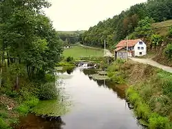 Glina in Maljevac | |
| Location | |
| Countries | |
| Physical characteristics | |
| Mouth | |
• location | Kupa |
• coordinates | 45°26′06″N 16°07′18″E |
| Length | 112.2 km (69.7 mi) [1] |
| Basin size | 1,427 km2 (551 sq mi) [1] |
| Basin features | |
| Progression | Kupa→ Sava→ Danube→ Black Sea |
Glina rises in the mountainous forested areas of Kordun, northeast of Slunj, near the village of Glinsko Vrelo (lit. "the source of Glina"). It flows north before turning east near the village of Veljunska Glina. As it reaches the village of Maljevac, it touches the border of Bosnia and Herzegovina (north of Velika Kladuša), whose path it forms (roughly) for about 18 km (11 mi) up to the village of Katinovac. There it turns northeast, passes by Topusko and finally the eponymous town of Glina. At the village of Marinbrod it turns north, and flows into the river Kupa southwest of Slana, at 45.434895°N 16.12178°E.
References
- "Sava River Basin Analysis Report" (PDF, 9.98 MB). International Sava River Basin Commission. September 2009. p. 13. Retrieved 2018-05-18.
Hydrography of Croatia | ||||||
|---|---|---|---|---|---|---|
| Rivers |
|  | ||||
| Lakes | ||||||
| Valleys, estuaries, canyons, wetlands | ||||||
| Waterfalls | ||||||
| Canals |
| |||||
| Adriatic Sea | ||||||