Goodland, Indiana
Goodland is a town in Grant Township, Newton County, in the U.S. state of Indiana.[6] The population was 1,043 at the 2010 census.
Goodland, Indiana | |
|---|---|
| Town of Goodland | |
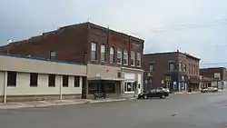 Newton Street in downtown Goodland | |
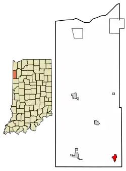 Location of Goodland in Newton County, Indiana. | |
| Coordinates: 40°45′52″N 87°17′42″W | |
| Country | United States |
| State | Indiana |
| County | Newton |
| Township | Grant |
| Area | |
| • Total | 0.76 sq mi (1.97 km2) |
| • Land | 0.76 sq mi (1.97 km2) |
| • Water | 0.00 sq mi (0.00 km2) |
| Elevation | 725 ft (221 m) |
| Population | |
| • Total | 1,043 |
| • Estimate (2019)[4] | 990 |
| • Density | 1,300.92/sq mi (502.44/km2) |
| Time zone | UTC-6 (Central (CST)) |
| • Summer (DST) | UTC-5 (CDT) |
| ZIP code | 47948 |
| Area code(s) | 219 |
| FIPS code | 18-28332[5] |
| GNIS feature ID | 435168 |
History
.jpg.webp)
Goodland was laid out in 1861.[7] The town was named from the quality of its soil.[8] A post office has been in operation at Goodland since 1861.[9]
The Goodland-Grant Township Public Library and McCairn-Turner House are listed on the National Register of Historic Places.[10]
Geography
According to the 2010 census, Goodland has a total area of 0.78 square miles (2.02 km2), all land.[11]
The Kentland crater, Which is a limestone quarry is located between Goodland and Kentland.
Demographics
| Historical population | |||
|---|---|---|---|
| Census | Pop. | %± | |
| 1880 | 628 | — | |
| 1890 | 889 | 41.6% | |
| 1900 | 1,205 | 35.5% | |
| 1910 | 1,105 | −8.3% | |
| 1920 | 1,120 | 1.4% | |
| 1930 | 978 | −12.7% | |
| 1940 | 1,097 | 12.2% | |
| 1950 | 1,218 | 11.0% | |
| 1960 | 1,202 | −1.3% | |
| 1970 | 1,176 | −2.2% | |
| 1980 | 1,200 | 2.0% | |
| 1990 | 1,033 | −13.9% | |
| 2000 | 1,096 | 6.1% | |
| 2010 | 1,043 | −4.8% | |
| 2019 (est.) | 990 | [4] | −5.1% |
| U.S. Decennial Census[12] | |||
2010 census
As of the census[3] of 2010, there were 1,043 people, 426 households, and 276 families living in the town. The population density was 1,337.2 inhabitants per square mile (516.3/km2). There were 469 housing units at an average density of 601.3 per square mile (232.2/km2). The racial makeup of the town was 97.5% White, 0.7% African American, 0.4% Native American, 0.5% from other races, and 1.0% from two or more races. Hispanic or Latino of any race were 2.1% of the population.
There were 426 households, of which 31.0% had children under the age of 18 living with them, 46.9% were married couples living together, 10.8% had a female householder with no husband present, 7.0% had a male householder with no wife present, and 35.2% were non-families. 27.9% of all households were made up of individuals, and 13.4% had someone living alone who was 65 years of age or older. The average household size was 2.45 and the average family size was 2.99.
The median age in the town was 42.3 years. 22.7% of residents were under the age of 18; 7.7% were between the ages of 18 and 24; 23.4% were from 25 to 44; 30.1% were from 45 to 64; and 16.1% were 65 years of age or older. The gender makeup of the town was 50.2% male and 49.8% female.
2000 census
As of the census[5] of 2000, there were 1,096 people, 434 households, and 291 families living in the town. The population density was 1,397.1 people per square mile (542.5/km2). There were 476 housing units at an average density of 606.8 per square mile (235.6/km2). The racial makeup of the town was 99.27% White, 0.09% Native American, 0.09% Asian, 0.09% from other races, and 0.46% from two or more races. Hispanic or Latino of any race were 0.82% of the population.
There were 434 households, out of which 32.9% had children under the age of 18 living with them, 56.2% were married couples living together, 8.3% had a female householder with no husband present, and 32.9% were non-families. 29.0% of all households were made up of individuals, and 15.4% had someone living alone who was 65 years of age or older. The average household size was 2.53 and the average family size was 3.13.
In the town, the population was spread out, with 28.3% under the age of 18, 6.1% from 18 to 24, 29.6% from 25 to 44, 20.8% from 45 to 64, and 15.2% who were 65 years of age or older. The median age was 36 years. For every 100 females, there were 98.2 males. For every 100 females age 18 and over, there were 91.2 males.
The median income for a household in the town was $35,952, and the median income for a family was $41,875. Males had a median income of $30,292 versus $21,607 for females. The per capita income for the town was $15,715. About 3.5% of families and 6.2% of the population were below the poverty line, including 3.0% of those under age 18 and 12.7% of those age 65 or over.
Education
The town has a lending library, the Goodland-Grant Township Public Library.[13]
Notable people
- Eddie Condon, jazz musician and bandleader
- Joe McConnell, sportscaster
- Marty Ravellette, armless hero
- Louis Sola, Federal Maritime Commission
- Andy Zimmer, basketball player for Indiana Hoosiers
| Wikimedia Commons has media related to Goodland, Indiana. |
References
- "2019 U.S. Gazetteer Files". United States Census Bureau. Retrieved July 16, 2020.
- "US Board on Geographic Names". United States Geological Survey. 2007-10-25. Retrieved 2008-01-31.
- "U.S. Census website". United States Census Bureau. Retrieved 2012-12-11.
- "Population and Housing Unit Estimates". United States Census Bureau. May 24, 2020. Retrieved May 27, 2020.
- "U.S. Census website". United States Census Bureau. Retrieved 2008-01-31.
- "Goodland, Indiana". Geographic Names Information System. United States Geological Survey. Retrieved 2017-05-06.
- Baker, Ronald L. (October 1995). From Needmore to Prosperity: Hoosier Place Names in Folklore and History. Indiana University Press. p. 147. ISBN 978-0-253-32866-3.
...1861, and the town was laid out the same year...
- Gannett, Henry (1905). The Origin of Certain Place Names in the United States. Govt. Print. Off. pp. 139.
- "Newton County". Jim Forte Postal History. Retrieved 9 September 2015.
- "National Register Information System". National Register of Historic Places. National Park Service. July 9, 2010.
- "G001 - Geographic Identifiers - 2010 Census Summary File 1". United States Census Bureau. Archived from the original on 2020-02-13. Retrieved 2015-07-16.
- "Census of Population and Housing". Census.gov. Retrieved June 4, 2015.
- "Indiana public library directory" (PDF). Indiana State Library. Retrieved 10 March 2018.
Municipalities and communities of Newton County, Indiana, United States | ||
|---|---|---|
| Towns | Map of Indiana highlighting Newton County | |
| Townships | ||
| CDPs | ||
| Other unincorporated communities | ||
| Footnotes | ‡This populated place also has portions in an adjacent county or counties | |
| ||
| Authority control |
|
|---|
