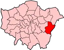
Grade I and II* listed buildings in the London Borough of Bexley
There are over 9,000 Grade I listed buildings and 20,000 Grade II* listed buildings in England. This page is a list of these buildings in the London Borough of Bexley.
See also the list of Grade II listed buildings in the London Borough of Bexley.
Grade I
| Name | Location | Type | Completed [note 1] | Date designated | Grid ref.[note 2] Geo-coordinates |
Entry number [note 3] | Image |
|---|---|---|---|---|---|---|---|
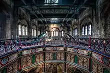
| Crossness Pumping Station | Belvedere | Pumping station | 1865 | 24 June 1970 | TQ4849781080 51°30′33″N 0°08′18″E |
1064241 | |
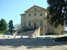
| Danson House | Welling | House | c.1765 | 1 October 1953 | TQ4727375179 51°27′23″N 0°07′06″E |
1064225 | |
| Garden wall, gatepiers and gates to north and west of Hall Place | Bexley | Gate | 18th century | 1 October 1953 | TQ5012174371 51°26′54″N 0°09′32″E |
1064250 | 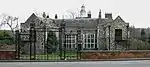 Garden wall, gatepiers and gates to north and west of Hall Place |
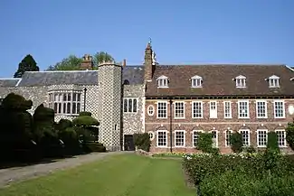
| Hall Place | Bexley | House | 16th century | 1 October 1953 | TQ5014574318 51°26′53″N 0°09′33″E |
1188277 | |
| Red House | Bexleyheath | House | 1859 | 25 May 1950 | TQ4810675093 51°27′20″N 0°07′49″E |
1064203 | |
| Well head to south-east of Red House | Bexleyheath | Well head | 1859 | 1 October 1953 | TQ4811575091 51°27′20″N 0°07′49″E |
1359397 | 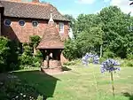 Well head to south-east of Red House |
Grade II*
| Name | Location | Type | Completed [note 1] | Date designated | Grid ref.[note 2] Geo-coordinates |
Entry number [note 3] | Image |
|---|---|---|---|---|---|---|---|
| Bath house to rear of Number 112 | Bexley | Bath house | c.1766 | 17 December 1980 | TQ4940073100 51°26′14″N 0°08′53″E |
1064236 |  |
| Christ Church | Erith | Church | 1874 | 17 December 1980 | TQ5124677889 51°28′47″N 0°10′36″E |
1188549 | %252C_Erith%252C_Kent_-_geograph.org.uk_-_143085.jpg.webp) Christ Church |
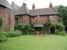
| Frognal House | Bexley | Country house | 17th century | 30 May 1978 | TQ4647070837 51°25′03″N 0°06′18″E |
1064228 | |
| Greek Orthodox Church | Welling | Parish church | 12th century | 1 October 1953 | TQ4677576947 51°28′21″N 0°06′43″E |
1188567 | 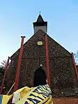 Greek Orthodox Church |
| Parish Church of All Saints | Foots Cray | Parish church | c.1863 | 25 August 1954 | TQ4757971293 51°25′17″N 0°07′16″E |
1064202 | 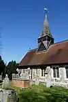 Parish Church of All Saints |
| Parish Church of St John the Baptist | Erith | Lych gate | 12th century | 20 May 1953 | TQ5076378725 51°29′15″N 0°10′12″E |
1188560 | 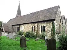 Parish Church of St John the Baptist |
| Parish Church of St Mary the Virgin | Bexley | Parish church | 13th century or earlier | 1 October 1953 | TQ4978573444 51°26′25″N 0°09′13″E |
1294750 | 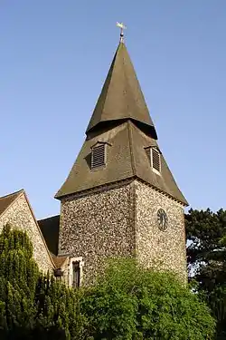 Parish Church of St Mary the Virgin |
| Parish Church of St Paulinus | Crayford | Parish church | c.1100 | 20 May 1952 | TQ5119475122 51°27′18″N 0°10′29″E |
1359434 | 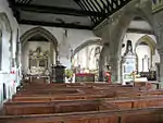 Parish Church of St Paulinus |
| Stables to Danson Park | Welling | Stable | c.1765 | 1 October 1953 | TQ4721775348 51°27′29″N 0°07′03″E |
1359409 | 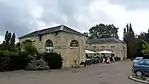 Stables to Danson Park |

Notes
- The date given is the date used by Historic England as significant for the initial building or that of an important part in the structure's description.
- Sometimes known as OSGB36, the grid reference is based on the British national grid reference system used by the Ordnance Survey.
- The "List Entry Number" is a unique number assigned to each listed building and scheduled monument by Historic England.
External links
 Media related to Grade I listed buildings in the London Borough of Bexley at Wikimedia Commons
- Media related to Grade II* listed buildings in the London Borough of Bexley at Wikimedia Commons
This article is issued from Wikipedia. The text is licensed under Creative Commons - Attribution - Sharealike. Additional terms may apply for the media files.