Grade I and II* listed buildings in the London Borough of Croydon
There are over 9,000 Grade I listed buildings and 20,000 Grade II* listed buildings in England. This page is a list of these buildings in the London Borough of Croydon.
Grade I
| Name | Location | Type | Completed [note 1] | Date designated | Grid ref.[note 2] Geo-coordinates |
Entry number [note 3] | Image |
|---|---|---|---|---|---|---|---|
| Church of All Saints | Sanderstead | Parish church | Late 13th century | 20 May 1954 | TQ3413861485 51°20′12″N 0°04′33″W |
1079341 | 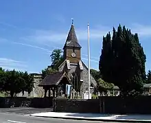 Church of All Saints |
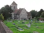
| Church of St John the Evangelist | Coulsdon | Church | 1250 | 20 May 1954 | TQ3127358187 51°18′28″N 0°07′05″W |
1188464 |  Church of St John the Evangelist |
| Church of St Mary Addington | Croydon | Church | 1080 | 29 January 1951 | TQ3710463991 51°21′30″N 0°01′56″W |
1079343 | |
| Hospital of the Holy Trinity (Whitgift Hospital) | Croydon | Almshouses | 1599 | 29 January 1951 | TQ3232565584 51°22′26″N 0°06′01″W |
1188846 |  Hospital of the Holy Trinity (Whitgift Hospital) |
| Old Palace School (Croydon Palace) | Croydon | Archbishop's palace | 15th century | 29 January 1951 | TQ3197065392 51°22′20″N 0°06′20″W |
1079296 | .JPG.webp) Old Palace School (Croydon Palace) |
| Parish Church of St John the Baptist | Croydon | Parish church | 15th century | 29 January 1951 | TQ3193665440 51°22′22″N 0°06′21″W |
1079319 | |
| Parish Church of St Michael and All Angels | Croydon | Parish church | 1880–85 | 20 May 1954 | TQ3226366068 51°22′42″N 0°06′03″W |
1079297 | 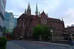 Parish Church of St Michael and All Angels |

Grade II*
| Name | Location | Type | Completed [note 1] | Date designated | Grid ref.[note 2] Geo-coordinates |
Entry number [note 3] | Image |
|---|---|---|---|---|---|---|---|
| Addington Palace (Royal School of Church Music) | Croydon | House | 1772 | 29 January 1951 | TQ3636963609 51°21′19″N 0°02′35″W |
1358819 |  Addington Palace (Royal School of Church Music) |
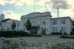
| Airport House | Croydon | Airport terminal | 1928 | 1 August 1978 | TQ3116663615 51°21′23″N 0°07′03″W |
1188970 | |
| Church of St Augustine | Croydon | Church | 1881–84 | 29 October 1976 | TQ3242463237 51°21′10″N 0°05′59″W |
1079301 |  Church of St Augustine |
| Church of St James | Croydon | Church | 1829 | 29 October 1976 | TQ3266766451 51°22′54″N 0°05′42″W |
1294484 |  Church of St James |
| St John the Evangelist | Upper Norwood | Church | 1878–87 | 29 October 1976 | TQ3360969805 51°24′42″N 0°04′49″W |
1079275 | |
| Church of St Mary Magdalene | Addiscombe | Church | 1868 | 29 October 1976 | TQ3353166011 51°22′39″N 0°04′58″W |
1358794 | 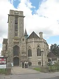 Church of St Mary Magdalene |
| Church of the Holy Innocents, and boundary wall | Croydon | Church | 1894–95 | 29 November 1976 | TQ3369768196 51°23′49″N 0°04′46″W |
1079303 | 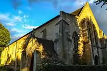 Church of the Holy Innocents, and boundary wall |
| Wrencote House | Croydon | House | Late 17th century | 29 January 1951 | TQ3238265149 51°22′12″N 0°05′59″W |
1079291 | 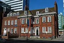 Wrencote House |
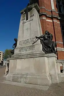
| Croydon War Memorial | Croydon | War memorial | 1921 | 19 November 1973 | TQ3239265405 51°22′20″N 0°05′58″W |
1268438 |

Notes
- The date given is the date used by Historic England as significant for the initial building or that of an important part in the structure's description.
- Sometimes known as OSGB36, the grid reference is based on the British national grid reference system used by the Ordnance Survey.
- The "List Entry Number" is a unique number assigned to each listed building and scheduled monument by Historic England.
External links
 Media related to Grade I listed buildings in the London Borough of Croydon at Wikimedia Commons
- Media related to Grade II* listed buildings in the London Borough of Croydon at Wikimedia Commons
This article is issued from Wikipedia. The text is licensed under Creative Commons - Attribution - Sharealike. Additional terms may apply for the media files.