Grade I and II* listed buildings in the London Borough of Redbridge
There are over 9,000 Grade I listed buildings and 20,000 Grade II* listed buildings in England. This page is a list of these buildings in the London Borough of Redbridge.
Grade I
| Name | Location | Type | Completed [note 1] | Date designated | Grid ref.[note 2] Geo-coordinates |
Entry number [note 3] | Image |
|---|---|---|---|---|---|---|---|
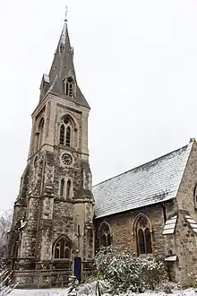
| Church of St Mary | Wanstead | Church | 1790 | 20 December 1954 | TQ4095787784 51°34′17″N 0°01′57″E |
1081008 |
.jpg.webp)
Grade II*
| Name | Location | Type | Completed [note 1] | Date designated | Grid ref.[note 2] Geo-coordinates |
Entry number [note 3] | Image |
|---|---|---|---|---|---|---|---|
| Chapel, Ilford Hospital of St Mary and St Thomas of Canterbury | Ilford | Chapel | Earlier origins | 10 April 1954 | TQ4354586368 51°33′29″N 0°04′09″E |
1300587 | |
| Christ Church | Wanstead | Church | 1860-1 | 11 November 1968 | TQ4037388468 51°34′39″N 0°01′28″E |
1081017 | |
| Dr Barnardo's Memorial | Barkingside | Exedra | 1908 | 22 February 1979 | TQ4450089520 51°35′10″N 0°05′04″E |
1081001 | |
| Former Merchant Seamen's Orphan Asylum at Wanstead Hospital. Chapel to the North West of Wanstead Hospital | Wanstead | Chapel | 1861-3 | 22 February 1979 | TQ4050089224 51°35′04″N 0°01′35″E |
1200737 | 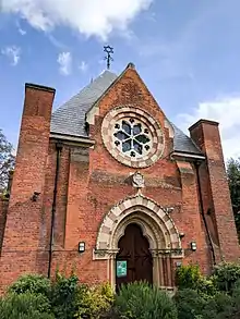 Former Merchant Seamen's Orphan Asylum at Wanstead Hospital. Chapel to the North West of Wanstead Hospital |
| Garden Temple in Back Garden of Number 14, The Avenue (Temple House) | Wanstead | Garden Temple | 1730–40 | 20 December 1954 | TQ4080488452 51°34′38″N 0°01′50″E |
1357974 |  |
| Gazebo and Grotto Below in Back Garden of Number 20, The Avenue | Wanstead | Gazebo | Early 18th century | 20 December 1954 | TQ4084688480 51°34′39″N 0°01′52″E |
1081021 | |
| Godfrey Monument in St Mary's Churchyard | Woodford | Commemorative Monument | c. 1742 | 22 February 1979 | TQ3999690703 51°35′52″N 0°01′11″E |
1357983 | 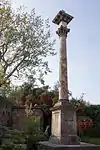 Godfrey Monument in St Mary's Churchyard |
| Hurst House, "The Naked Beauty" | Woodford Green | House | Early 18th century | 20 December 1954 | TQ3998091332 51°36′12″N 0°01′11″E |
1357975 | %252C_Woodford_Green.jpg.webp) Hurst House, "The Naked Beauty" |
| Pair of Gatepiers at Entrance to Overton Drive | Wanstead | Gate Pier | 1715–22 | 20 December 1954 | TQ4034787582 51°34′11″N 0°01′25″E |
1081022 |  Pair of Gatepiers at Entrance to Overton Drive |
| Raikes Mausoleum in St Mary's Churchyard | Woodford | Sarcophagus | c. 1797 | 22 February 1979 | TQ3999090737 51°35′53″N 0°01′11″E |
1183475 | 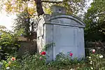 Raikes Mausoleum in St Mary's Churchyard |
| Railings, Gates and Gatepiers to Valentines Park | Ilford | Gate | Late 18th century | 10 April 1954 | TQ4335187771 51°34′14″N 0°04′01″E |
1081027 | 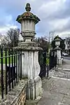 Railings, Gates and Gatepiers to Valentines Park |
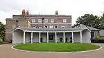
| Valentines Mansion | Ilford | Country House | Late 17th century | 10 April 1954 | TQ4329887939 51°34′20″N 0°03′59″E |
1081014 |
.jpg.webp)
Notes
- The date given is the date used by Historic England as significant for the initial building or that of an important part in the structure's description.
- Sometimes known as OSGB36, the grid reference is based on the British national grid reference system used by the Ordnance Survey.
- The "List Entry Number" is a unique number assigned to each listed building and scheduled monument by Historic England.
External links
 Media related to Grade I listed buildings in the London Borough of Redbridge at Wikimedia Commons
- Media related to Grade II* listed buildings in the London Borough of Redbridge at Wikimedia Commons
| Districts |
|  |
|---|---|---|
| Attractions |
| |
| Constituencies | ||
| Parks and open spaces |
| |
| Tube and rail stations | ||
| History | ||
| Other topics | ||
| ||
This article is issued from Wikipedia. The text is licensed under Creative Commons - Attribution - Sharealike. Additional terms may apply for the media files.