Grant Park, Illinois
Grant Park is a village in northeastern Kankakee County, Illinois, United States. Grant Park was incorporated in 1883.[3] In 2010, Grant Park had a population of 1,331.[4] It is part of the Kankakee–Bradley Metropolitan Statistical Area. Much of the town was destroyed by a cyclone in 1912, according to Frank Leslie's Weekly magazine, which ran pictures.
Grant Park | |
|---|---|
| Village of Grant Park | |
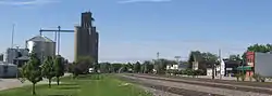 Grant Park, Illinois, Looking South | |
 Location of Grant Park in Illinois | |
.svg.png.webp) Location of Illinois in the United States | |
| Coordinates: 41.240656°N 87.645842°W | |
| Country | United States |
| State | Illinois |
| County | Kankakee |
| Area | |
| • Total | 3.44 sq mi (8.90 km2) |
| • Land | 3.41 sq mi (8.84 km2) |
| • Water | 0.03 sq mi (0.07 km2) |
| Elevation | 695 ft (212 m) |
| Population (2010) | |
| • Total | 1,331 |
| • Estimate (2019)[2] | 1,249 |
| • Density | 365.95/sq mi (141.31/km2) |
| Time zone | UTC-6 (CST) |
| • Summer (DST) | UTC-5 (CDT) |
| ZIP Code | 60940 |
| Area code(s) | 815 and 779 |
| FIPS code | 17-30991 |
| Website | www |
Geography
Grant Park is located at 41°14′26″N 87°38′45″W (41.240656, -87.645842).[5]
According to the 2010 census, Grant Park has a total area of 3.436 square miles (8.90 km2), of which 3.41 square miles (8.83 km2) (or 99.24%) is land and 0.026 square miles (0.07 km2) (or 0.76%) is water.[6]
| Historical population | |||
|---|---|---|---|
| Census | Pop. | %± | |
| 1880 | 279 | — | |
| 1890 | 340 | 21.9% | |
| 1900 | 442 | 30.0% | |
| 1910 | 692 | 56.6% | |
| 1920 | 459 | −33.7% | |
| 1930 | 508 | 10.7% | |
| 1940 | 519 | 2.2% | |
| 1950 | 564 | 8.7% | |
| 1960 | 757 | 34.2% | |
| 1970 | 914 | 20.7% | |
| 1980 | 1,038 | 13.6% | |
| 1990 | 1,024 | −1.3% | |
| 2000 | 1,358 | 32.6% | |
| 2010 | 1,331 | −2.0% | |
| 2019 (est.) | 1,249 | [2] | −6.2% |
| U.S. Decennial Census[7] | |||
Demographics
According to the 2000 census,[8] there were 1,358 people, 497 households, and 389 families residing in the village. The population density was 2,196.2 people per square mile (845.7/km2). There were 517 housing units at an average density of 836.1 per square mile (322.0/km2). The racial makeup of the village was 97.57% White, 0.07% African American, 0.07% Native American, 0.22% Asian, 0.81% from other races, and 1.25% from two or more races. Hispanic or Latino of any race were 2.72% of the population.
There were 497 households, out of which 39.8% had children under the age of 18 living with them, 63.8% were married couples living together, 11.3% had a female householder with no husband present, and 21.7% were non-families. 17.1% of all households were made up of individuals, and 8.0% had someone living alone who was 65 years of age or older. The average household size was 2.73 and the average family size was 3.09.
In the village, the population was spread out, with 28.4% under the age of 18, 7.0% from 18 to 24, 31.4% from 25 to 44, 21.6% from 45 to 64, and 11.6% who were 65 years of age or older. The median age was 36 years. For every 100 females, there were 94.6 males. For every 100 females age 18 and over, there were 91.2 males.
The median income for a household in the village was $52,153, and the median income for a family was $55,250. Males had a median income of $45,694 versus $22,750 for females. The per capita income for the village was $22,403. About 3.5% of families and 4.4% of the population were below the poverty line, including 5.0% of those under age 18 and 9.2% of those age 65 or over.
Weather Events
1912 Cyclone
In 1912 a large tornado swept through grant park destroying several homes in the northern portion of the village, injuring multiple residents.
1948 Tornado
A second large scale tornado struck grant park April 7th, killing 3, and injuring 8. Extensive damage to homes and livestock was done. this tornado is considered the worst tornado in the history of Kankakee County.
1954 Tornado
On April 7th, 1954 a third tornado caused one fatality, and two minor injuries. Several millions of dollars in damage was done.
2020 Tornado
On August 10th, 2020 a relatively small tornado touched down in Grant Park. It caused major damage to trees and roofs along its path, which ended just nearing Lake Matonga. This tornado formed from the bigger August 2020 Midwest derecho.
Education
Grant Park contains a preschool, elementary school, middle school, and a high school. The mascot for the elementary school, middle school, and high school is the Dragons and the colors are green and gold.
The high school followed a block schedule in which students attend four 87-minute class periods a day, but is now going back to 8 hours a day and tray lunches.
As of 2014, the district's superintendent is Dr. John Palan, Matthew Maxwell is the high school and middle school principal, and Tracy Planeta is principal of the elementary school.[9] http://www.daily-journal.com/news/local/maxwell-named-new-grant-park-principal/article_a29ad022-86b6-506b-837e-5c53f8c30356.html</ref>
Notable people
- Richard L. Alexander, World War II fighter ace, was born here
- Dimitrius George Piperas, 2016 Homecoming King, ran over in the school parking lot in the year 2015, was born here
See also
References
- "2019 U.S. Gazetteer Files". United States Census Bureau. Retrieved July 14, 2020.
- "Population and Housing Unit Estimates". United States Census Bureau. May 24, 2020. Retrieved May 27, 2020.
- "Archived copy". Archived from the original on 2007-09-30. Retrieved 2007-04-21.CS1 maint: archived copy as title (link)
- "https://www.census.gov/2010census/popmap/ipmtext.php?fl=17". Archived from the original on 2013-06-15. Retrieved 2013-06-15. External link in
|title=(help) - "US Gazetteer files: 2010, 2000, and 1990". United States Census Bureau. 2011-02-12. Retrieved 2011-04-23.
- "G001 - Geographic Identifiers - 2010 Census Summary File 1". United States Census Bureau. Archived from the original on 2020-02-13. Retrieved 2015-08-03.
- "Census of Population and Housing". Census.gov. Retrieved June 4, 2015.
- "U.S. Census website". United States Census Bureau. Retrieved 2008-01-31.
- As of early 2017, Matt Maxwell of BBCHS will be the principal after Sanidas' retirement.
External links
| Wikimedia Commons has media related to Grant Park, Illinois. |
Municipalities and communities of Kankakee County, Illinois, United States | ||
|---|---|---|
| Cities | Map of Illinois highlighting Kankakee County | |
| Villages | ||
| Townships | ||
| Unincorporated communities | ||
| Footnotes | ‡This populated place also has portions in an adjacent county or counties. | |
| ||
