Greenwood Township, Juniata County, Pennsylvania
Greenwood Township is a township in Juniata County, Pennsylvania, United States. The population was 617 at the 2010 census,[3] up from 548 at the 2000 census.
Greenwood Township, Juniata County, Pennsylvania | |
|---|---|
 | |
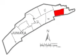 Map of Juniata County, Pennsylvania highlighting Greenwood Township | |
 Map of Juniata County, Pennsylvania
| |
| Country | United States |
| State | Pennsylvania |
| County | Juniata |
| Settled | 1763 |
| Incorporated | 1767 |
| Area | |
| • Total | 19.46 sq mi (50.40 km2) |
| • Land | 19.46 sq mi (50.40 km2) |
| • Water | 0.00 sq mi (0.00 km2) |
| Population (2010) | |
| • Total | 617 |
| • Estimate (2016)[2] | 627 |
| • Density | 32.22/sq mi (12.44/km2) |
| Time zone | UTC-5 (EST) |
| • Summer (DST) | UTC-4 (EDT) |
| Zip code | 17062 |
| Area code(s) | 717 |
| FIPS code | 42-067-31424 |
History
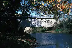
The Dimmsville Covered Bridge was listed on the National Register of Historic Places in 1979.[4] It collapsed in 2017.
Geography
Greenwood Township is in eastern Juniata County and is centered on Turkey Valley, with Shellys Ridge and Lock Ridge to the south. Cocolamus Creek, a tributary of the Juniata River, flows through the western part of the township. According to the United States Census Bureau, the township has a total area of 19.5 square miles (50.4 km2), of which 0.9 acres (3,723 m2), or 0.01%, are water.[3]
Greenwood Township is bordered by Monroe Township to the north, Susquehanna Township to the east, Greenwood Township, Perry County to the south, and Delaware Township to the west. Unincorporated communities in the township include Seven Stars and Dimmsville.
Pennsylvania Route 235 passes through the township, leading east to Liverpool on the Susquehanna River, and west to East Salem.
Demographics
| Historical population | |||
|---|---|---|---|
| Census | Pop. | %± | |
| 1850 | 1,651 | — | |
| 1860 | 635 | −61.5% | |
| 1870 | 744 | 17.2% | |
| 1880 | 601 | −19.2% | |
| 1890 | 569 | −5.3% | |
| 1900 | 563 | −1.1% | |
| 1910 | 447 | −20.6% | |
| 1920 | 433 | −3.1% | |
| 1930 | 349 | −19.4% | |
| 1940 | 357 | 2.3% | |
| 1950 | 286 | −19.9% | |
| 1960 | 353 | 23.4% | |
| 1970 | 387 | 9.6% | |
| 1980 | 486 | 25.6% | |
| 1990 | 493 | 1.4% | |
| 2000 | 548 | 11.2% | |
| 2010 | 617 | 12.6% | |
| 2016 (est.) | 627 | [2] | 1.6% |
| U.S. Decennial Census[5] | |||
As of the census[6] of 2000, there were 548 people, 194 households, and 152 families residing in the township. The population density was 27.9 people per square mile (10.8/km2). There were 223 housing units at an average density of 11.3/sq mi (4.4/km2). The racial makeup of the township was 98.54% White, 0.73% African American, 0.18% Asian, and 0.55% from two or more races. Hispanic or Latino of any race were 0.73% of the population.
There were 194 households, out of which 33.0% had children under the age of 18 living with them, 74.7% were married couples living together, 2.1% had a female householder with no husband present, and 21.6% were non-families. 16.5% of all households were made up of individuals, and 7.7% had someone living alone who was 65 years of age or older. The average household size was 2.82 and the average family size was 3.24.
In the township the population was spread out, with 27.0% under the age of 18, 6.9% from 18 to 24, 27.6% from 25 to 44, 25.7% from 45 to 64, and 12.8% who were 65 years of age or older. The median age was 38 years. For every 100 females there were 105.2 males. For every 100 females age 18 and over, there were 99.0 males.
The median income for a household in the township was $40,139, and the median income for a family was $40,417. Males had a median income of $32,054 versus $20,875 for females. The per capita income for the township was $17,344. About 5.0% of families and 7.0% of the population were below the poverty line, including 5.4% of those under age 18 and 5.5% of those age 65 or over.
References
- "2016 U.S. Gazetteer Files". United States Census Bureau. Retrieved Aug 14, 2017.
- "Population and Housing Unit Estimates". Retrieved June 9, 2017.
- "Geographic Identifiers: 2010 Census Summary File 1 (G001): Greenwood township, Juniata County, Pennsylvania". American Factfinder. U.S. Census Bureau. Archived from the original on February 13, 2020. Retrieved November 21, 2018.
- "National Register Information System". National Register of Historic Places. National Park Service. July 9, 2010.
- "Census of Population and Housing". Census.gov. Retrieved June 4, 2016.
- "U.S. Census website". United States Census Bureau. Retrieved 2008-01-31.
Municipalities and communities of Juniata County, Pennsylvania, United States | ||
|---|---|---|
| Boroughs | | |
| Townships | ||
| CDPs | ||
| Unincorporated communities | ||
| Footnotes | ‡This populated place also has portions in an adjacent county or counties. | |
| ||