Mexico, Juniata County, Pennsylvania
Mexico is an unincorporated community and census-designated place (CDP) in Walker Township, Juniata County, Pennsylvania, United States. The population was 472 at the 2010 census.[1]
Mexico, Pennsylvania | |
|---|---|
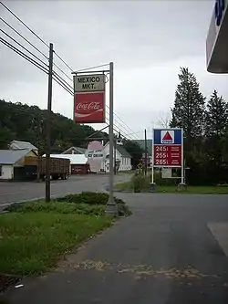 Mexico Mkt. and gas station | |
 Mexico  Mexico | |
| Coordinates: 40°32′36″N 77°21′17″W | |
| Country | United States |
| State | Pennsylvania |
| County | Juniata |
| Township | Walker |
| Area | |
| • Total | 1.08 sq mi (2.81 km2) |
| • Land | 1.08 sq mi (2.81 km2) |
| • Water | 0.0 sq mi (0.0 km2) |
| Elevation | 443 ft (135 m) |
| Population (2010) | |
| • Total | 472 |
| • Density | 436/sq mi (168.2/km2) |
| Time zone | UTC-5 (Eastern (EST)) |
| • Summer (DST) | UTC-4 (EDT) |
| ZIP code | 17056 |
| Area code(s) | 717 |
| FIPS code | 42-48904 |
| GNIS feature ID | 1180983 |
Geography
Mexico is located in central Juniata County at 40°32′36″N 77°21′17″W (40.543341, -77.354771),[2] in the western part of Walker Township. It is bordered to the south by the Juniata River. U.S. Routes 22 and 322 run together as a four-lane expressway along the northeast edge of the community, with access from PA 75 at the northern tip of the community. Routes 22 and 322 lead northwest 17 miles (27 km) to Lewistown and southeast 27 miles (43 km) to Duncannon. PA 75 leads southwest 1.4 miles (2.3 km) across the Juniata River to Port Royal, and the William Penn Highway (old Routes 22/322) leads northwest 3 miles (5 km) to Mifflintown, the Juniata county seat.
According to the United States Census Bureau, the Mexico CDP has a total area of 1.1 square miles (2.8 km2), all of it land.[1]
Demographics
As of the census[3] of 2000, there were 279 people, 112 households, and 89 families residing in the CDP. The population density was 375.7 people per square mile (145.6/km²). There were 116 housing units at an average density of 156.2/sq mi (60.5/km²). The racial makeup of the CDP was 98.57% White, 1.08% African American, and 0.36% from two or more races.
There were 112 households, out of which 25.9% had children under the age of 18 living with them, 63.4% were married couples living together, 10.7% had a female householder with no husband present, and 20.5% were non-families. 18.8% of all households were made up of individuals, and 9.8% had someone living alone who was 65 years of age or older. The average household size was 2.49 and the average family size was 2.79.
In the CDP the population was spread out, with 20.1% under the age of 18, 8.2% from 18 to 24, 26.5% from 25 to 44, 31.5% from 45 to 64, and 13.6% who were 65 years of age or older. The median age was 41 years. For every 100 females there were 96.5 males. For every 100 females age 18 and over, there were 93.9 males.
The median income for a household in the CDP was $35,417, and the median income for a family was $35,833. Males had a median income of $21,908 versus $19,063 for females. The per capita income for the CDP was $16,620. 10.0% of the population and 7.1% of families were below the poverty line. Out of the total people living in poverty, 20.3% are under the age of 18 and 0.0% are 65 or older.
References
- "Geographic Identifiers: 2010 Census Summary File 1 (G001): Mexico CDP, Pennsylvania". American Factfinder. U.S. Census Bureau. Archived from the original on February 13, 2020. Retrieved November 27, 2018.
- "US Gazetteer files: 2010, 2000, and 1990". United States Census Bureau. 2011-02-12. Retrieved 2011-04-23.
- "U.S. Census website". United States Census Bureau. Retrieved 2008-01-31.
Municipalities and communities of Juniata County, Pennsylvania, United States | ||
|---|---|---|
| Boroughs | 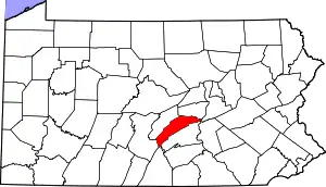 | |
| Townships | ||
| CDPs | ||
| Unincorporated communities | ||
| Footnotes | ‡This populated place also has portions in an adjacent county or counties. | |
| ||