Grimsbury
Grimsbury is a largely residential area forming the eastern part of Banbury, Oxfordshire, England. It is east of the River Cherwell, the Oxford Canal and the Cherwell Valley Line railway.
| Grimsbury | |
|---|---|
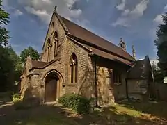 St Leonard's church, Grimsbury | |
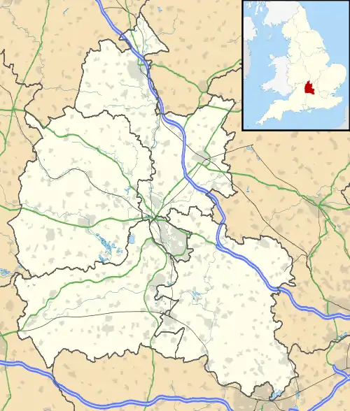 Grimsbury Location within Oxfordshire | |
| OS grid reference | SP4641 |
| Civil parish | |
| District | |
| Shire county | |
| Region | |
| Country | England |
| Sovereign state | United Kingdom |
| Post town | Banbury |
| Postcode district | OX16 |
| Dialling code | 01295 |
| Police | Thames Valley |
| Fire | Oxfordshire |
| Ambulance | South Central |
| UK Parliament | |
History
Grimsbury was first settled in the 6th century as a Saxon hamlet.[1] and for centuries was a village separate from Banbury. The placename is a corruption of the Saxon name for a defended enclosure (burh) of a person called Grim. It is possible that the name was derived from a pseudonym for the pagan god Woden.[2][3]
Grimsbury currently includes the town's Royal Mail sorting offices, which were built over the former Banbury Merton Street railway station, Banbury railway station, Banbury United F.C.'s ground, and the Victoria Place apartment development.
Local living conditions had improved greatly during the Victorian era with the removal of several poorly built cottages that were deemed to be only "hovels" and an end to the endemic "dwarfism" and rickets that had plagued the local children in the early 19th century. A slightly later development still further east in Grimsbury was of larger houses. A lot of cottages what was called 'Waterloo' (today's Waterloo Road), which apparently lay just east of Banbury Bridge to the north of the road, had transformed from the early 19th century so that by 1841 Waterloo was considered one of the better off parts of Grimsbury. Due to Banbury's then boom time Grimsbury's principle expansion occurred between 1852 and 1881, when some 500 houses were built, around Middleton road, Causeway, Merton Street, Duke Street, and North Street.[4]
When meadows and a by the recently discussed race-course at Grimsbury were sold to the Great Western Railway circa 1850, the owner also sold the other part of his land, north of the Middleton road to the Banbury Freehold Land Society, which was financially backed by Cobb's Bank, to build middle-class type houses on, but development was slow at the time and some plots were never built upon.[4] The land in question and the location of today's Spice Ball Park are marked as "Liable to flooding" on the 1882, 1900, 1910 and 1922 Ordnance Survey maps.
Duke Street, was located at the western edge of Wilkins' (now demolished) brick pit, was developed around 1870.[2][3] There was a substantial 'brick, tile and drain works' with a short tramway in it to the east of Grimsbury in the versinaty of Howard Street according to the 1882, 1883 1900, 1910, 1922 1923 and 1947 Ordnance Survey maps. It had closed by 1923[2][3] and the last workshops had shut in 1955. It was mostly built on by 1965 according to the 1955 and 1965 O.S. maps.
The Banbury Town Council built the houses in King's Road and on the Easington estate at the time and other working-class type houses were built at the south end of Britannia Road and the area to the east between 1881 and 1930, and also in both Old Grimsbury Road and Gibbs Road in Grimsbury, and more up-market houses were built in both the Marlborough Road area and in Bath Road, Kings Road, Park Road, and Queen Street in Neithrop.[5][6] The mostly late 19th-century suburb of Grimsbury witnessed rapid growth between 1881 and 1930. About 300 more houses were built after 1945, in the areas of Grimsbury Square, Fergusson Road, Howard Street, School View, and Edward Street. To the north of Grimsbury Square is the 1945–55 area of "New Grimsbury" and south of it is the 1930 and earlier old town of "Old Grimsbury".[5][6]
Grimsbury, Old and New, were historically hamlets in Warkworth parish, Northamptonshire, but which were transferred in 1889 to the parish of Bodicote, Oxfordshire.[7]
A retail and residential development was built on the former site of the Bridge Motors Vauxhall dealership and garage and opened in 2010.
The region has in recent decades been home to many Asian families and in recent years has been settled by many Eastern Europe immigrants.
Grimsbury is on a floodplain and suffered severe floods in 1998 and 2007.
Recent Events
Workmen found a fizzing and burning incendiary chemical that was suspected to be left over from a long-demolished First World War munitions factory and ammunition testing range. Thames Valley Police closed the Tesco Express, The Pepper Pot pub and the Atlantis Fish bar and set up a 100 m (330 ft) cordon on 19 April 2012.
Three World War I phosphorus grenades on 20 April and an unreleased number of anti-tank grenades were destroyed on the 24th . The area around the Tesco Express Middleton Road, Grimsbury, witnessed the disposal of several lost pieces of World War I ordnance that remained buried after the closure of the local ammunition testing range. They were reckoned to be part of a batch of 20 that were lost in 1919. . On the 26th some World War II smoke bombs were also disposed of. Fire station manager Mick Clarke said fire crews and the Royal Logistics Corps were disposing of them .
New Grimsbury
The post-1945 housing estate is situated at the northern end of the first (old) Grimsbury estate. About 300 more houses were built after 1945, in the areas of Grimsbury Square, Fergusson Road, Howard Street, School View, and Edward Street. To the north of Grimsbury Square is the 1945–55 area referred to as New Grimsbury. South of it is the old town of "Old Grimsbury" built prior to 1930.[5][6] It was expanded in both the late 1950s and early 1960s with a mixture of working-class and middle-class homes. Further minor expansions were also taking place towards the north of the estate in 2008–2011.
Axis and Market Quarter housing estates
Grimsbury was expanded further as the Market Quarter housing development has begun on the former cattle market site, along with the new Axis housing estate just to the east, which has added over 300 new homes and a primary school to replace Dashwood School.
The former cattle market
Grimsbury was once home to Western Europe's largest cattle market, on Merton Street in Grimsbury. The market was a key feature of Victorian life both in the town and countryside. In the late 1920s the economy of Banbury was revolutionised by the arrival of new industries and in particular by the relocation of the out of town livestock market to Grimsbury it used to be held in Neithrop and/or Bridge Street, Banbury. The new site selected due to its proximity to the railway station.[2][3] It was formally closed in June 1998, after being abandoned several years earlier and was replaced with a new housing development and Dashwood Banbury Academy, a primary school.[1]
Overthorpe, Thorp Way and Wildermere industrial estates
Banbury Rural District had built another water works on the present site in the 1890s as the need for formal sewerage treatment as well as water purification grew as the town expanded ever outward as illustrated in the 1882, 1900, 1910 and 1922 Ordnance Survey maps. It would be expanded after World War II and modernised thereafter. Banbury Rural District built a reservoir near today's Hennef Way road circa the late 1960s.
The 1960s industrial estates are home to both many local and national firms such as Prodrive, a Cherwell District Council depot and the town's sewerage works. It was later expanded in the mid to late 1990s and in the district council announced plans to expand it slightly eastward, but nothing has ever come of it since.
Churches
Grimsbury Wesleyan Chapel in West Street was a neoclassical brick and stone building completed in 1871.[9] The present Methodist church in West Street is modern.
The Church of England parish church of Saint Leonard was designed by the local architect Walter Mills and built in 1890.[9] It is a Gothic Revival building with north and south aisles joined to the nave by four-bay arcades.[9]
St Leonard's was a chapel of ease to Christ Church in Broad Street until 1921, when Grimsbury was constituted as a separate parish with Saint Leonard's as its church. In 1931 a fire destroyed much of the south side of St Leonard's and thereafter the church was redecorated and a new vestry built.
In 1978 a new Church of England Parish of Banbury, comprising four districts, was inaugurated. In 1998 the Banbury Team Ministry was dissolved and St. Leonard's reinstated as a separate parish.
In 2001 a new dais was built in the nave of St Leonard's and the High Altar was placed in the centre. The font was also moved from the south aisle and placed in the nave at the west end of the church.
In 2003 the church was redecorated with the central pillars being painted to reflect the decoration of the ceiling which is believed to have been designed in the style of a canal narrowboat.
Schools
There are two primary schools in Grimsbury.
Dashwood Banbury Academy moved from Dashwood Road on the other side of the river to brand-new buildings in Merton Street in 2008. The school is part of a Federation with the town's main secondary school, Wykham Park Academy, formerly Banbury School. It has 200 pupils. It is unusual for an Oxfordshire primary school in having a school uniform which was introduced in 2009. The headteacher is Vicki McLean.
St Leonard's Church of England Primary School[10] was originally Christchurch School. Its original buildings were designed by the Oxford Diocesan architect G.E. Street and built in 1860–61.[9]
Recreational areas and parks
The town centre's Bankside park is near the railway bridge, on the opposite canal to Grimsbury.
The Howard Road play area is in Grimsbury.
The Verney Road play area, Chaldons Road play area and urban park and Alma Road village green are all in the Market Quarter estate .
There is also one other park and one minor playground on the seat.
Pubs and bars
There are three local public houses: The Bell Inn and The Elephant and Castle are next to the Londis shop and the bridge into Banbury town centre. The Pepper Pot is on the junction of Middleton Road and Daventry road.
Transport
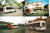
Stagecoach Oxfordshire run a majority of services in the area, which are:
Service B6 between Banbury Town Centre and Banbury Gateway Shopping Park
Service 200 between Banbury Town Centre and Daventry via Woodford Halse
Service 500 between Banbury Town Centre and Brackley via Middleton Cheney (every other bus serves Chacombe)
Service 505 between Banbury Town Centre and Bicester (once a day)
Redline Buses run service 132 twice a week on a Saturday between Buckingham and Banbury
Kidlington Assisted Transport operate the B7A service, which is a Grimsbury circular service
See also
References
- "The history of Banbury, Oxfordshire". information-britain.co.uk.
- http://webarchive.nationalarchives.gov.uk/20110927031316/http://www.cherwell.gov.uk/media.cfm?mediaid=2147
- "Archived copy" (PDF). Archived from the original (PDF) on 22 July 2011. Retrieved 26 January 2011.CS1 maint: archived copy as title (link)
- "Banbury: Origins and growth of the town". british-history.ac.uk.
- "Banbury: Local government". british-history.ac.uk.
- "Banbury: Economic history". british-history.ac.uk.
- "Grimsbury, Old and New, Northamptonshire". ukga.org.
- "Homepage – Thames Water – Contact us, pay your bill, tell us you're moving". thameswater.co.uk.
- Sherwood & Pevsner, 1974, page 444
- St Leonard's C.E. Primary School Archived 18 October 2012 at the Wayback Machine
Sources and further reading
- Crossley, Alan (ed.); Colvin, Christina; Cooper, Janet; Cooper, N.H.; Harvey, P.D.A.; Hollings, Marjory; Hook, Judith; Jessup, Mary; Lobel, Mary D.; Mason, J.F.A.; Trinder, B.S.; Turner, Hilary (1972). A History of the County of Oxford, Volume 10. Victoria County History. pp. 18–28.CS1 maint: extra text: authors list (link)
- Sherwood, Jennifer; Pevsner, Nikolaus (1974). Oxfordshire. The Buildings of England. Harmondsworth: Penguin Books. p. 444. ISBN 0-14-071045-0.
