Guáimaro
Guáimaro is a town and municipality in the southern part of Camagüey Province in Cuba. It is located between the cities of Camagüey and Las Tunas.
Guáimaro | |
|---|---|
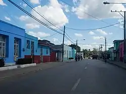 Main street | |
.png.webp) Guáimaro municipality (red) within Camagüey Province (yellow) and Cuba | |
| Coordinates: 21°03′32″N 77°20′52″W | |
| Country | Cuba |
| Province | Camagüey |
| Established | 1924[1] |
| Area | |
| • Total | 1,847 km2 (713 sq mi) |
| Elevation | 80 m (260 ft) |
| Population (2004)[3] | |
| • Total | 57,086 |
| • Density | 30.9/km2 (80/sq mi) |
| Time zone | UTC-5 (EST) |
| Area code(s) | +53-322 |
| Climate | Aw |
History
Guáimaro features prominently in Cuban history as the place where in 1869, at the beginning of the Ten Years' War, the Revolutionary Army of Mambises met and created the Guáimaro Constitution for a new nation free from Spanish colonial oppression. The municipality was created in 1943, when it split from Camagüey.
Geography
The municipality is divided into the barrios of Camaniguán, Elia, Galbis, Guáimaro, Palo Seco, Pilar and Tetuán.[1]
Demographics
In 2004, the municipality of Guáimaro had a population of 57,086.[3] With a total area of 1,847 km2 (713 sq mi),[2] it has a population density of 30.9/km2 (80/sq mi).
See also
References
- Guije.com. "Guáimaro" (in Spanish). Retrieved 2007-10-05.
- Statoids. "Municipios of Cuba". Retrieved 2007-10-05.
- Atenas.cu (2004). "2004 Population trends, by Province and Municipality" (in Spanish). Archived from the original on 2007-09-27. Retrieved 2007-10-05.
External links
| Wikimedia Commons has media related to Guáimaro. |
- (in Spanish) Camaguey-Guaimaro
- (in Spanish) Town history
Places adjacent to Guáimaro | |
|---|---|
This article is issued from Wikipedia. The text is licensed under Creative Commons - Attribution - Sharealike. Additional terms may apply for the media files.
