Guil
The Guil (French: le Guil) is a 51.6-kilometre (32.1 mi) long river in the Hautes-Alpes département, southeastern France.[1] Its drainage basin is 727 km2 (281 sq mi).[2] Its source is several small streams which converge into the lake Lestio, at Ristolas. It flows generally west, through the Queyras. It is a left tributary of the Durance into which it flows at Guillestre.
| Guil | |
|---|---|
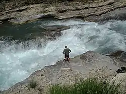 The Guil. | |
.png.webp) | |
| Location | |
| Country | France |
| Physical characteristics | |
| Source | |
| • location | Ristolas |
| • coordinates | 44°41′14″N 07°03′56″E |
| • elevation | 2,510 m (8,230 ft) |
| Mouth | |
• location | Durance |
• coordinates | 44°40′01″N 06°36′05″E |
• elevation | 875 m (2,871 ft) |
| Length | 51.6 km (32.1 mi) |
| Basin size | 727 km2 (281 sq mi) |
| Discharge | |
| • average | 17 m3/s (600 cu ft/s) |
| Basin features | |
| Progression | Durance→ Rhône→ Mediterranean Sea |
Communes along its course
This list is ordered from source to mouth: Ristolas, Abriès, Aiguilles, Château-Ville-Vieille, Arvieux, Eygliers, Guillestre
Notes
- This article is based on the equivalent article from the French Wikipedia, consulted on 23 April 2009.
References
- Sandre. "Fiche cours d'eau - Le Guil (X02-0400)".
- Bassin versant : Guil (Le), Observatoire Régional Eau et Milieux Aquatiques en PACA
This article is issued from Wikipedia. The text is licensed under Creative Commons - Attribution - Sharealike. Additional terms may apply for the media files.