Ristolas
Ristolas is a former commune in the Hautes-Alpes department in southeastern France. On 1 January 2019, it was merged into the new commune of Abriès-Ristolas.[2]
Ristolas | |
|---|---|
Part of Abriès-Ristolas | |
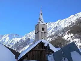 The church of Ristolas | |
 Coat of arms | |
Location of Ristolas 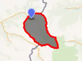
| |
 Ristolas  Ristolas | |
| Coordinates: 44°46′29″N 6°57′23″E | |
| Country | France |
| Region | Provence-Alpes-Côte d'Azur |
| Department | Hautes-Alpes |
| Arrondissement | Briançon |
| Canton | Guillestre |
| Commune | Abriès-Ristolas |
| Area 1 | 82.18 km2 (31.73 sq mi) |
| Population (2017)[1] | 86 |
| • Density | 1.0/km2 (2.7/sq mi) |
| Time zone | UTC+01:00 (CET) |
| • Summer (DST) | UTC+02:00 (CEST) |
| Postal code | 05460 |
| Elevation | 1,571–3,294 m (5,154–10,807 ft) (avg. 1,610 m or 5,280 ft) |
| 1 French Land Register data, which excludes lakes, ponds, glaciers > 1 km2 (0.386 sq mi or 247 acres) and river estuaries. | |
Population
| Year | Pop. | ±% |
|---|---|---|
| 2006 | 91 | — |
| 2007 | 93 | +2.2% |
| 2008 | 96 | +3.2% |
| 2009 | 96 | +0.0% |
| 2010 | 90 | −6.2% |
| 2011 | 80 | −11.1% |
| 2012 | 71 | −11.3% |
| 2013 | 69 | −2.8% |
| 2014 | 68 | −1.4% |
| 2015 | 73 | +7.4% |
| 2016 | 80 | +9.6% |
Politics
Presidential Elections Second Round:[3]
| Election | Winning Candidate | Party | % | |
|---|---|---|---|---|
| 2017 | Emmanuel Macron | EM | 81.82 | |
| 2012 | François Hollande | PS | 62.69 | |
| 2007 | Nicolas Sarkozy | UMP | 50.67 | |
| 2002 | Jacques Chirac | RPR | 92.31 | |
Geography
The village lies in the Queyras, in the northwestern part of the commune, on the left bank of the Guil, which has its source in the southeastern part of the commune.
References
- Téléchargement du fichier d'ensemble des populations légales en 2017, INSEE
- "Arrêté préfectoral portant création de la commune nouvelle d'Abriès-Ristolas" (pdf) (in French). Recueil des actes administratifs spécial n°05-2018-161. 17 October 2018. pp. 79–80.
- http://www.lemonde.fr/data/france/presidentielle-2017/
| Wikimedia Commons has media related to Ristolas. |
| Authority control |
|
|---|
This article is issued from Wikipedia. The text is licensed under Creative Commons - Attribution - Sharealike. Additional terms may apply for the media files.
