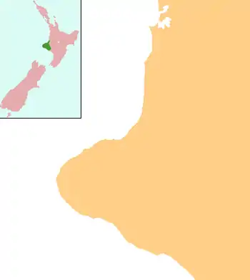
Hāwera
Hāwera is the second-largest centre in the Taranaki region of New Zealand's North Island, with a population of 10,300.[1] It is near the coast of the South Taranaki Bight. The origins of the town lie in a government military base that was established in 1866, and the town of Hāwera grew up around a blockhouse in the early 1870s.
Hāwera | |
|---|---|
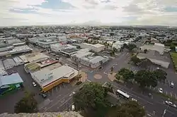 Hāwera from the Water Tower | |
 Hāwera | |
| Coordinates: 39°35′36″S 174°16′42″E | |
| Country | New Zealand |
| Region | Taranaki |
| District | South Taranaki District |
| Established | 1866 |
| Government | |
| • Mayor | Phil Nixon |
| Population (June 2020) | |
| • Total | 10,300 |
| Postcode | 4610 |
Hāwera is 75 kilometres south of New Plymouth on State Highway 3 and 30 minutes' drive from Mount Taranaki. It is located on State Highway 45, known as Surf Highway 45 for its numerous surf beaches. State Highway 45 passes through Manaia, Opunake and Oakura en route to New Plymouth. Kaponga is a 20-minute drive to the north-west. The Marton–New Plymouth Line railway passes through Hāwera and has served the town since 1 August 1881, though it has been freight-only since the cancellation of the last railcar passenger service between Wellington and New Plymouth on 30 July 1977.
History
Pre-European history
The Māori-language name Hāwera means "burnt place"; it arose as a result of fighting between two local sub-tribes, which culminated in the setting ablaze of the sleeping whare (house) of the tribe under attack.[2] An older Māori name was Tau-patatē, referring to the patatē or seven-finger tree Schefflera digitata.[3] Spelled "Hawera" for most of its European history, a macron was added to the official name by the New Zealand Geographic Board in June 2019.[4]
European settlement
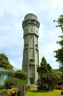
The town's name meaning "burnt place" became apt when the town suffered extensive blazes in 1884, 1888, and 1912.[5]
For this reason a large water tower was built in the centre of town to increase water pressure; and this became one of Taranaki's best-known landmarks (appearing, for example, on the cover of the 1974 telephone directory). After falling into disrepair the tower was closed to the public in 2001, but after an extensive restoration program it opened again in 2004.[6]
Marae
There are four marae in the Hāwera area:
- Ngātiki Marae is affiliated with the Ngāti Ruanui hapū of Hāmua and Ngāti Hawe.
- Te Rangatapu Marae and its Aorangi meeting house are affiliated with the Ngāruahine hapū of Kanihi-Umutahi and Ōkahu-Inuāwai.
- Taiporohēnui Marae and its Whareroa meeting house are affiliated with the Ngāti Ruanui hapū of Hāmua and Hāpōtiki.
- Wharepuni Marae and its Tūpaia meeting house are affiliated with the Ngāti Ruanui hapū of Ngāti Tānewai and Ngāti Tūpaea.
In October 2020, the Government committed $1,479,479 from the Provincial Growth Fund to renovate Meremere Marae, Ketemarae Pā, Pariroa Marae and Taiporohēnui Marae, creating 35 jobs.[7]
Demography
The Hāwera urban area had a usual resident population of 9,792 at the 2018 New Zealand census, an increase of 663 people (7.3%) since the 2013 census, and an increase of 978 people (11.1%) since the 2006 census. There were 4,776 males and 5,019 females, giving a sex ratio of 0.95 males per female. Of the total population, 2,043 people (20.9%) were aged up to 15 years, 1,764 (18.0%) were 15 to 29, 4,071 (41.6%) were 30 to 64, and 1,911 (19.5%) were 65 or older.[8]
In terms of ethnicity, 78.8% were European/Pākehā, 27.5% were Māori, 1.9% were Pacific peoples, 5.0% were Asian, and 2.2% were other ethnicities (totals add to more than 100% since people could identify with multiple ethnicities).[8]
| SA2 name | Population | Dwellings | Median age | Median income |
|---|---|---|---|---|
| Egmont Showgrounds | 1,734 | 687 | 42.2 years | $33,900 |
| Hawera Central | 2,592 | 1,185 | 41.3 years | $25,300 |
| King Edward Park | 1,521 | 627 | 40.2 years | $25,200 |
| Ramanui | 2,052 | 819 | 38.4 years | $27,500 |
| Turuturu | 1,893 | 762 | 36.2 years | $31,900 |
Economy
The Whareroa dairy factory, 4 km south-southwest of the township, is the largest dairy complex in the world in terms of output.[10] The complex is owned by Fonterra, having been built by the former Kiwi Co-operative Dairies, whose original plant opened on that site in 1975.
During peak season, the complex employs 1,000 people and processes up to 14 million litres of milk per day. Electricity and heat used at Whareroa is generated by an on-site gas-fired power plant, with excess electricity fed into the national grid.[11]
Hāwera is home to Tawhiti Museum,[12] well known for its hand-crafted life-sized mannequins depicting scenes of local heritage and history, and its scale models of local Māori pā.[13]
Education
Hawera Primary School was established in 1875. It developed into a District High School in 1901. The current high school opened as Hawera Technical High School in 1919, and moved to its present site in 1921.[14] The intermediate school opened in 1961.[15]
The Western Institute of Technology at Taranaki has a campus in Hāwera,[16] established in 1990.[17]
Hawera High School is a secondary (years 9–13) school with a roll of approximately 711. Hawera Intermediate is an intermediate (years 7–8) school with a roll of 304.[18]
Hawera Primary School, Ramanui School, Tawhiti School and Turuturu School are contributing primary (years 1–6) schools with rolls of 194, 67, 266 and 265 respectively.[18] Hawera Primary celebrated its 125th jubilee in 2000.[19] Ramanui school celebrated its 50th jubilee in 2003.[20]
Hawera Christian School and St Joseph's School are state integrated full primary (years 1–8) schools with rolls of 25 and 271 respectively.
Te Kura Kaupapa Maori o Ngati Ruanui is a full primary (years 1–8) school with a roll of 48. It is a Kura Kaupapa Māori school which teaches in the Māori language.
All these schools are coeducational.
Politics
Hāwera is in the South Taranaki district. After serving four terms as mayor of South Taranaki, Ross Dunlop did not stand in the 2019 election, and was replaced as mayor by District Councillor Phil Nixon.[21]
Notable people
- Aroha Awarau, journalist
- Michael Bent, rugby player
- Pat Booth, investigative journalist
- Cameron Brewer, Auckland councillor
- Alan Brough, actor and comedian
- Michael Campbell, professional golfer
- Tim Chadwick, artist and author
- Geoffrey Duncan Chisholm, surgeon
- Ben Hurley, comedian and cricket commentator
- Peter Ingram, cricket player
- Fiona Kidman, writer
- Issac Luke, rugby league player
- John Gildroy Grant, World War I Victoria Cross recipient
- Nicola Kawana, actress
- John Mitchell, rugby union player and coach
- Ronald Hugh Morrieson, author
- Alan Stuart Paterson, cartoonist
- John Plumtree, rugby union player and coach
- Conrad Smith, All Black rugby union player
- Elijah Taylor, rugby league player
- Adine Wilson, Silver Ferns netballer
References
- "Population estimate tables - NZ.Stat". Statistics New Zealand. Retrieved 22 October 2020.
- Because of differing oral traditions, translations such as "breath of fire" and "burning plains" have also been offered. See A.H. McLintock, ed. (1966), "HAWERA", An Encyclopaedia of New Zealand, retrieved 1 January 2008 – via Te Ara - The Encyclopaedia of New Zealand
- Elsdon Best. "Transactions and Proceedings of the Royal Society of New Zealand 1868-1961 Volume 40, 1907". Maori Forest Lore: being some Account of Native Forest Lore and Woodcraft, as also of many Myths, Rites, Customs, and Superstitions connected with the Flora and Fauna of the Tuhoe or Ure-wera District. National Library of New Zealand. Retrieved 8 October 2019.
- "Hāwera". NZGB Gazetteer | linz.govt.nz. Retrieved 19 April 2020.
- For a near-contemporary account of the damage these fires caused, see D. Nimmo Scott (c. 1895), Views of Hawera: before and after the fire, Hawera, [N.Z.]: D. Nimmo Scott; a more recent one is Arthur Fryer; Nigel Ogle (ill.) (2003), Hawera's on fire, Hawera, [N.Z.]: Hawera Historical Society. For details of Hawera's Fire Brigade, see Trevor N. Moore (1982), Hawera Fire Brigade, 1882-1982: a centennial history, Hawera, [N.Z.]: The Brigade
- Craig Stevenson; Hugo Jackson, Hawera Water Tower Restoration (PDF), Contech, archived from the original (PDF) on 14 October 2008
- "Marae Announcements" (Excel). growregions.govt.nz. Provincial Growth Fund. 9 October 2020.
- "Age and sex by ethnic group (grouped total response), for census usually resident population counts, 2006, 2013, and 2018 Censuses (urban rural areas)". nzdotstat.stats.govt.nz. Retrieved 13 September 2020.
- "2018 Census place summaries | Stats NZ". www.stats.govt.nz. Retrieved 14 December 2020.
- "Largest dairy factory in the world", Te Ara
- The Whareroa Co-generation plant, www.toddenergy.co.nz
- For an account of the Museum by the man who built it, see Nigel Ogle (199–?), Nigel Ogle's Tawhiti Museum, Hawera, [N.Z.]: The Museum Check date values in:
|year=(help) - Perhaps Hāwera's most famous example of a nineteenth-century Maori pa is the Turuturu-Mokai complex, on Turuturu Road. See John Houston (1958), Turuturu-Mokai: historic reserve near Hawera: an historical survey, Hawera, [N.Z.]: Hawera Star Print. For information upon a modern pa, see Gloria Kerehoma (1984), Commemorative centennial [i.e. centennial] booklet, 1884-1984, Hawera, [N.Z.]: Centennial Committee; Shore Print on Aotearoa Pa.
- Fryer, Arthur (1994), The Beginnings of Hawera High School, Hawera High School Jubilee Magazine, archived from the original on 14 October 2008
- School Info, Hawera Intermediate, archived from the original on 14 October 2008
- Campus Maps, Western Institute of Technology
- WITT History, Western Institute of Technology
- "New Zealand Schools Directory". New Zealand Ministry of Education. Retrieved 26 April 2020.
- "Jubilees & reunions - Hawera Primary School", Education Gazette New Zealand, 78 (10), 14 June 1999
- "Ramanui Primary School 50th Jubilee", Education Gazette New Zealand, 82 (5), 24 March 2003
- Persico, Christina (12 October 2019). "Phil Nixon wins South Taranaki mayoralty by large margin". Taranaki Daily News.
External links
| Wikivoyage has a travel guide for Hāwera. |
| Wikimedia Commons has media related to Hawera. |
- Hawera information page from the South Taranaki District Council